Iberian Peninsula
| Iberian Peninsula | |
 Location of the different countries and territories |
|
| Geographical location | |
| Coordinates | 40 ° N , 4 ° W |
| Waters 1 | Atlantic Ocean |
| Waters 2 | Mediterranean Sea |
| surface | 583,254 km² |
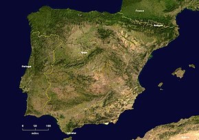
The Iberian peninsula (from Latin Hiberi / Iberi , the inhabitants of the countryside Hiberia in Hispania ' ) or Iberian Peninsula is the part of Europe , the southwest of the Pyrenees and south-west of France lies. Spain takes up about 85% of the area, Portugal 15%, the Principality of Andorra in the northeast and the British overseas territory Gibraltar at the southern tip of the peninsula. The 14 km narrow Strait of Gibraltar separates the peninsula from Africa.
topography
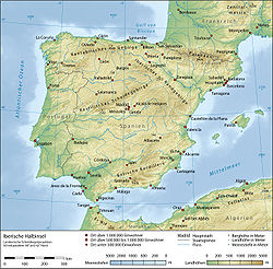
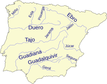
The peninsula is crossed by five large rivers ( Ebro , Guadiana , Guadalquivir , Tajo (Spanish) or Tejo (Portuguese) and Duero (Spanish) or Douro (Portuguese) ) and is almost completely enclosed by mountain ranges. In the north, the western continuation of the Pyrenees, the Cantabrian Mountains , separates the Bay of Biscay with the Costa Verde from a plateau, the so-called Meseta (from Spanish Mesa = table ), which occupies a large part of the inland. Salamanca , León and Burgos are the dominant places. The Meseta is divided into a north and south half by the Castilian Scheidegebirge . In the southwest the plateau merges into the more mountainous Extremadura , with which it forms a geologically one unit. Aragon , the river system of the Ebro, forms a river triangle around Saragossa in the east south of the Pyrenees , which is separated from the Mediterranean by a low mountain range (especially the Costa Brava ) .
East-West Rivers
The river systems of the Duero , Tajo , Guadiana and Guadalquivir - enumerated from north to south - run from east to west across the Iberian Peninsula. They have their common origin in the Sierras of the Iberian Mountains (Spanish: Sistema Ibérico ). The Iberian mountain range forms from the West views the sharp eastern edge of the central panel country and is the main watershed between the Atlantic Ocean and the Mediterranean.
- The Duero flows into the Atlantic at Porto .
- The Tajo / Tejo roughly follows the line Madrid , Toledo , Alcántara , Santarém and Lisbon .
- The Guadiana runs along the Guadisa , Castilblanco, Villanueva de la Serena , Don Benito , Mérida , Badajoz and Ayamonte lines . With its final stretch from Badajoz to the south, it forms roughly the eastern border between Portugal and Spain.
- The Guadalquivir follows the line Córdoba , Seville to Sanlúcar de Barrameda and Cádiz . It is navigable from the Atlantic to Cordoba.
Mountains and coastal mountains
The north coast of Spain runs almost in a straight line and only forms more significant protrusions to the north between Gijón and Avilés and between Ribadeo and A Coruña ( La Coruña in Spanish ). In the west, the mountain ranges of the Galicia region join. The river Bidasoa , which forms the border between Spain and France, runs into the Bay of Biscay on the northwestern foothills of the Pyrenees between Hendaye and Irun .
The south and east coasts form the Sierra Nevada with its foothills and promontories ending in the sea. The highest mountain on the peninsula is the Mulhacén at 3482 m , which is located in Andalusia in the province of Granada . The coastal sections in front of the Mediterranean Sea form the bays / gulfs of Cádiz , Málaga , Almería , Cartagena , Alicante and the Gulf of Valencia (from west to east).
The European Fold Mountains are matched by the folding of the Atlas Mountains on the northwest side of the African Plate .
Portuguese coastal regions
The Portuguese coastal regions form the southwest of the peninsula. The Minho lies in the north-west and in the north-east Trás-os-Montes ("behind the mountains").
The most important landscapes in central Portugal are the Beira , the Ribatejo (the Tagus plain, nicknamed "Garden of Lisbon"), the Estremadura and the mouth of the Tejo.
The south of Portugal is made up of the three landscapes Terras do Sado , Alentejo and Algarve (from north to south).
story
The name of the Iberian Peninsula is derived from the ethnic or tribal group of the Iberians who, according to Greek tradition, inhabited the peninsula in ancient times . Their name is derived from the river Ebro ( Latin Iberus ), which flows from northeast Spain into the Mediterranean .
Iberia (Ιβηρία) was the Greek name for this area.
In Latin, the region was called Hispania , from which España and Spain are derived. The Roman province of Lusitania in the southwest of the peninsula comprised most of what is now Portugal as well as parts of Extremadura . Lusitania therefore became the Latin name of Portugal, Germanized Lusitania .
In the Middle Ages , large parts of the Iberian Peninsula belonged to the Islamic world. The Moorish influence has shaped Hispanic culture in a lasting way. From the 8th century to January 2, 1492 (victory over Boabdil ), the gradual Reconquista ("reconquest") of Al-Andalus took place by the Christian empires. The remaining Muslims and also the Spanish Jews, the Sephardim , had to leave Spain or convert to Christianity in the course of these wars of conquest.
Countries and territories
| area | population | Size (km²) | capital city |
|---|---|---|---|
|
|
42.167.337 | 493,519 | Madrid |
|
|
10,077,388 | 89,261 | Lisbon |
|
|
81,222 | 467.76 | Andorra la Vella |
|
|
27,967 | 6.50 | ---- |
| All in all | 52.353.914 | 583.254 |
See also
literature
- Debora Gerstenberger: Iberia in the mirror of early modern encyclopedic lexicons of Europe. Analysis of the history of discourse on Spanish and Portuguese national stereotypes of the 17th and 18th centuries ( Contributions to Economic and Social History , Volume 110). Franz Steiner, Stuttgart 2007.
Web links
Individual evidence
- ^ Karl Ernst Georges : Comprehensive Latin-German concise dictionary . 8th, improved and enlarged edition. Hahnsche Buchhandlung, Hanover 1918 ( zeno.org [accessed April 11, 2019]).
- ↑ Information on Portugal without Madeira and on Spain without the Azores , Balearic Islands , Canaries , Ceuta and Melilla , as these areas are not on the continental shelf .


