
Alcántara (Spain)
| Alcántara municipality | |||
|---|---|---|---|
 Alcántara - Roman bridge and city
|
|||
| coat of arms | Map of Spain | ||

|
|
||
| Basic data | |||
| Autonomous Community : | Extremadura | ||
| Province : | Cáceres | ||
| Comarca : | Tagus Salor | ||
| Coordinates | 39 ° 43 ′ N , 6 ° 53 ′ W | ||
| Height : | 240 msnm | ||
| Area : | 551.99 km² | ||
| Residents : | 1,468 (Jan 1, 2019) | ||
| Population density : | 2.66 inhabitants / km² | ||
| Postal code : | 10980 | ||
| Municipality number ( INE ): | 10008 | ||
| administration | |||
| Website : | Alcantara | ||

Alcántara is a small Spanish town and a municipality ( municipio ) consisting of the main town and three hamlets ( pedanías ) with 1,468 inhabitants (as of 2019) in the province of Cáceres ( Extremadura ). The place name is from Arabicالقنطرة / al-qanṭara derived, which literally means "the bridge". The historic town center is classified as Conjunto histórico-artístico .
location
The city is located on a hill on the southeast bank of the Tagus near the border with Portugal at an altitude of approximately 240 m above sea level. d. M. The distance to the provincial capital Cáceres is about 65 km (driving distance) in a south-easterly direction; the city of Badajoz is about 115 km south. The climate is temperate to warm; Rain (approx. 500 mm / year) falls mainly in the winter half-year.
Population development
| year | 1842 | 1900 | 1950 | 2000 | 2016 |
| Residents | 4,272 | 3,248 | 4.151 | 1,650 | 1,518 |
The significant population decline since the 1950s is mainly due to the mechanization of agriculture and the associated loss of jobs.
economy
Wine and olive cultivation has been practiced in the area since Roman times. The cultivation of wheat and other crops used to be mainly self-sufficient. Today the most important source of income for the place is tourism.
history
The remains of megalithic dolmens can be found in the municipality and in the vicinity . The place was later in the border area of the Celtic Lusitanians and Vettonen , but so far no finds have been made. Around the year 200 BC BC the Romans conquered the southern part of the Iberian Peninsula . The possibly already existing place was on an important trade and military connection in the province of Lusitania and was upgraded around the year 105 AD by a bridge over the Tagus River . Again, no news is known from the late medieval and Visigoth times. After the Arab-Moorish conquest of the Iberian Peninsula in the 8th century, the place and its bridge continued to be important, but there are no concrete reports or discoveries. In 1213 the area was occupied by the troops of Alfonso IX. Recaptured ( reconquista ) by León (reigned 1188–1230) and handed over to the Calatrava order . A few years later (1218), the place came under the authority of the existing, but now named after him, Alcántara Knight Order . In 1580 a battle against Portuguese army units, which was ultimately victorious for the Spaniards, took place near the town. In 1703, Philip V (r. 1700–1746) declared war with Portugal as part of the War of Spanish Succession from Alcántara, which underpinned the fact that the place belonged to Spain.
Attractions

.jpg)

- The landmark of the place is the 194 m long bridge of Alcántara from Roman times built at a narrow point of the Tagus ; it is the largest completely preserved (and still passable) Roman bridge in the world.
- The Order of the Alcántara resided in the Convento de San Benito (Benedictine Monastery) in the heart of the old town until 1835 . The building, which was extended by Charles V to include a representative gallery wing with side stair towers , is now the seat of the San Benito de Alcántara Foundation , which awards the international architecture prize Premio Internacional Puente de Alcántara every two years for outstanding engineering structures . The associated church dates from the 14th century. The three-aisled interior , like a hall church, has star vaults of the same height and a polygonal broken apse with stone heraldic shields.
- The construction of the church of Santa María de Almocóvar , built in the style of the late Romanesque over a destroyed mosque , was in 1254. What is particularly interesting is its portal, which protrudes slightly from the façade, but is then stepped down several times, with set columns and a multi - pass arch .
- In the village or just outside there are other churches and chapels - including the Church of the Franciscan Order from 1493 , which belongs to the Convento de San Bartolomé .
- The barrier structure of the “José María Oriol” dam is located approx. 600 m upstream from the Roman bridge.
- Surroundings
- Approx. 20 km northwest of the village is the hamlet of Segura , near which there is another Roman bridge ( Puente de Segura ) over the Río Erjas .

Benedict monastery (former seat of the Alcántara order )

Parish Church of Santa María de Almocóvar
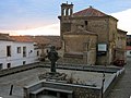
Square with the monument of St. Peter

Barrier structure of the "José María Oriol" dam


sons and daughters of the town
- Saint Peter of Alcantara (1499–1562), Spanish mystic, penitential preacher and Franciscan order reformer
See also
Web links
Individual evidence
- ↑ Cifras oficiales de población resultantes de la revisión del Padrón municipal a 1 de enero . Population statistics from the Instituto Nacional de Estadística (population update).
- ↑ Alcántara - map with altitude information
- ↑ Alcántara - climate tables
- ↑ Alcántara - population development
- ^ Alcántara - Benedict's Convent
- ↑ Alcántara - Church of Santa María de Almocóvar
- ^ Alcántara - Convento de San Bartolomé
Abadía | Abertura | Acebo | Acehúche | Aceituna | Ahigal | Alagón del Río | Albalá | Alcántara | Alcollarín | Alcuéscar | Aldea del Cano | La Aldea del Obispo | Aldeacentenera | Aldeanueva de la Vera | Aldeanueva del Camino | Aldehuela de Jerte | Alía | Aliseda | Almaraz | Almoharín | Arroyo de la Luz | Arroyomolinos | Arroyomolinos de la Vera | Baños de Montemayor | Barrado | Belvís de Monroy | Benquerencia | Berrocalejo | Berzocana | Bohonal de Ibor | Botija | Brozas | Cabañas del Castillo | Cabezabellosa | Cabezuela del Valle | Cabrero | Cáceres | Cachorrilla | Cadalso | Calzadilla | Caminomorisco | Campillo de Deleitosa | Campo Lugar | Cañamero | Cañaveral | Carbajo | Carcaboso | Carrascalejo | Casar de Cáceres | Casar de Palomero | Casares de las Hurdes | Casas de Don Antonio | Casas de Don Gómez | Casas de Millán | Casas de Miravete | Casas del Castañar | Casas del Monte | Casatejada | Casillas de Coria | Castañar de Ibor | Ceclavín | Cedillo | Cerezo | Cilleros | Collado | Conquista de la Sierra | Coria | Cuacos de Yuste | La Cumbre | Deleitosa | Descargamaría | Eljas | Escurial | Fresnedoso de Ibor | Galisteo | Garciaz | La Garganta | Garganta la Olla | Gargantilla | Gargüera | Garrovillas de Alconétar | Garvín | Gata | El Gordo | La Granja | Guadalupe | Guijo de Coria | Guijo de Galisteo | Guijo de Granadilla | Guijo de Santa Bárbara | Herguijuela | Hernán-Pérez | Herrera de Alcántara | Herreruela | Hervás | Higuera | Hinojal | Holguera | Hoyos | Huélaga | Ibahernando | Jaraicejo | Jaraíz de la Vera | Jarandilla de la Vera | Jarilla | Jerte | Ladrillar | Logrosán | Losar de la Vera | Madrigal de la Vera | Madrigalejo | Madroñera | Majadas | Malpartida de Cáceres | Malpartida de Plasencia | Marchagaz | Mata de Alcántara | Membrío | Mesas de Ibor | Miajadas | Millanes | Mirabel | Mohedas de Granadilla | Monroy | Montánchez | Montehermoso | Moraleja | Morcillo | Navaconcejo | Navalmoral de la Mata | Navalvillar de Ibor | Navas del Madroño | Navezuelas | Nuñomoral | Oliva de Plasencia | Palomero | Pasarón de la Vera | Pedroso de Acim | Peraleda de la Mata | Peraleda de San Román | Perales del Puerto | Pescueza | La Pesga | Piedras Albas | Pinofranqueado | Piornal | Plasencia | Plasenzuela | Portaje | Portezuelo | Pozuelo de Zarzón | Puerto de Santa Cruz | Rebollar | Riolobos | Robledillo de Gata | Robledillo de la Vera | Robledillo de Trujillo | Robledollano | Romangordo | Rosalejo | Ruanes | Salorino | Salvatierra de Santiago | San Martín de Trevejo | Santa Ana | Santa Cruz de la Sierra | Santa Cruz de Paniagua | Santa Marta de Magasca | Santiago de Alcántara | Santiago del Campo | Santibáñez el Alto | Santibáñez el Bajo | Saucedilla | Segura de Toro | Serradilla | Serrejón | Sierra de Fuentes | Talaván | Talaveruela de la Vera | Talayuela | Tejeda de Tiétar | Tiétar | Toril | Tornavacas | El Torno | Torre de Don Miguel | Torre de Santa María | Torrecilla de los Ángeles | Torrecillas de la Tiesa | Torrejón el Rubio | Torrejoncillo | Torremenga | Torremocha | Torreorgaz | Torrequemada | Trujillo | Valdastillas | Valdecañas de Tajo | Valdefuentes | Valdehúncar | Valdelacasa de Tajo | Valdemorales | Valdeobispo | Valencia de Alcántara | Valverde de la Vera | Valverde del Fresno | Viandar de la Vera | Vegaviana | Villa del Campo | Villa del Rey | Villamesías | Villamiel | Villanueva de la Sierra | Villanueva de la Vera | Villar de Plasencia | Villar del Pedroso | Villasbuenas de Gata | Zarza de Granadilla | Zarza de Montánchez | Zarza la Mayor | Zorita