Pinofranqueado
| Pinofranqueado municipality | ||
|---|---|---|
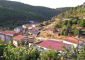
 Pinofranqueado - View of the hamlet of Horcajo
|
||
| coat of arms | Map of Spain | |

|
|
|
| Basic data | ||
| Autonomous Community : | Extremadura | |
| Province : | Cáceres | |
| Comarca : | Las Hurdes | |
| Coordinates | 40 ° 18 ′ N , 6 ° 20 ′ W | |
| Height : | 450 msnm | |
| Area : | 146.84 km² | |
| Residents : | 1,736 (Jan 1, 2019) | |
| Population density : | 11.82 inhabitants / km² | |
| Postal code : | 10630 | |
| Municipality number ( INE ): | 10146 | |
| administration | ||
| Website : | Pinofranqueado | |
Pinofranqueado is a place and a Spanish municipality ( municipio ) with 1,736 inhabitants (as of 2019) in the extreme north of the province of Cáceres in the autonomous region of Extremadura . The municipality also includes the hamlets (pedanías) Aldehuela , Avellanar , Castillo , Erías , Horcajo , Mesegal , Muela , Ovejuela , Robledo and Sauceda, each with between 15 and 100 inhabitants .
location
The place Pinofranqueado belongs to the municipalities of the Hurdes and is located approx. 120 km (driving distance) north of the provincial capital Cáceres near the border to the neighboring region Castile-León in the southern foothills of the Iberian Mountains at an altitude of approx. d. M. The place is at the confluence of the Río Esperabán in the Río de los Angeles . The climate is temperate to warm; Rain (approx. 550 mm / year) falls mainly in the winter half-year.
Population development
| year | 1857 | 1900 | 1950 | 2000 | 2017 |
| Residents | k. A. | 1,093 | 2.023 | 1,693 | 1,785 |
The population decline since the 1950s is mainly due to the abandonment of small farms and the associated loss of jobs.
economy
The area has served the people since ancient times as a summer pasture for their herds of sheep and goats. After settling down, olives , vines and figs began to be grown ; later other types of fruit (apples, cherries, etc.) were added. In earlier centuries, the cultivation of barley and other crops served mainly for self-sufficiency . The most important trade goods were charcoal as well as cheese and honey . Nowadays the most important source of income for the place is tourism in the form of the rental of holiday homes (casas rurales) .
history
Neolithic hunters and gatherers roamed the area; some seem to have stayed longer because there are several places with incised drawings ( petroglyphs ). The Celts , Romans , Visigoths and Moors paid only marginal attention to the mountain region used by cattle nomads ( transhumants ) as summer pasture. The first permanent settlements probably emerged in the High Middle Ages, but at that time there were neither churches nor chapels; these only emerged between the 17th and 19th centuries.
Attractions
- The Church of Nuestra Señora de la Encina is a rather impressive building for the area from the 17th and 18th centuries.
- Surroundings
- The hamlets of Erías , Horcajo and Ovejuela also have smaller churches. In Ovejuela you can also see the ruins of a Franciscan convent .
Web links
Individual evidence
- ↑ Cifras oficiales de población resultantes de la revisión del Padrón municipal a 1 de enero . Population statistics from the Instituto Nacional de Estadística (population update).
- ↑ Pinofranqueado - Map with altitude information
- ↑ Pinofranqueado - Climate tables
- ↑ Pinofranqueado - Population Development
- ↑ Pinofranqueado - History

