Baños de Montemayor
| Baños de Montemayor municipality | ||
|---|---|---|
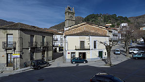
 Baños de Montemayor - the townscape
|
||
| coat of arms | Map of Spain | |

|
|
|
| Basic data | ||
| Autonomous Community : | Extremadura | |
| Province : | Cáceres | |
| Comarca : | Valle del Ambroz | |
| Coordinates | 40 ° 19 ′ N , 5 ° 51 ′ W | |
| Height : | 710 msnm | |
| Area : | 21.89 km² | |
| Residents : | 759 (Jan 1, 2019) | |
| Population density : | 34.67 inhabitants / km² | |
| Postal code : | 10750 | |
| Municipality number ( INE ): | 10024 | |
| administration | ||
| Website : | Baños de Montemayor | |
Baños de Montemayor is a town in western Spain and a municipality ( municipio ) with 759 inhabitants (as of January 1, 2019) in the province of Cáceres in the extreme north of the autonomous region of Extremadura near the border with the region of Castile and León .
Location and climate
The place Baños de Montemayor is located in a wooded area at an altitude of approx. 710 m . The distance to the neighboring town of Hervás to the south is only about 7 km (driving distance); the city of Béjar in the neighboring province of Castile and León is only about 17 km to the northeast. The next major city is Plasencia, about 56 km southwest . The climate in the winter months is quite cool, while in summer it is warm to hot; the rather sparse amounts of precipitation (approx. 510 mm / year) fall mainly in the winter half-year.
Population development
| year | 1857 | 1900 | 1950 | 2000 | 2017 |
| Residents | 1,420 | 1,807 | 1,502 | 695 | 774 |
The population decline since the middle of the 20th century is essentially due to the mechanization of agriculture and the abandonment of small farms; Both of these have led to a loss of jobs and, as a consequence, to a migration of part of the population to the cities ( rural exodus ).
economy
For centuries, the residents of the village lived largely on self-sufficiency from the yields of the small fields and, above all, from raising cattle. Today, fruit and vegetable growing and forestry play the most important roles in the economic life of the municipality; in addition, the spa and hiking tourism also plays an important role.
history
The area was probably around 500 BC. Settled by the Celtic tribe of the Vettonen ; the Romans built a road nearby and used the thermal springs of today's place. Visigoths and Moors , on the other hand, have left no traces on the high municipal area and so the real history of the place only begins after the reconquest ( reconquista ) and repopulation ( repoblación ) of the region in the 12th and 13th centuries. In the late Middle Ages and early modern times, Baños belonged to the Comunidad de Villa y Tierra de Béjar , hence to Castile and León ; after the territorial reform of 1833, the place came to the Comunidad de Villa y Tierra de Plasencia and thus to the Extremadura region.
Attractions
- The local thermal springs were discovered and used by the Romans - they are the most important in the Extremadura region.
- The parish church of Santa María de la Asunción is a handsome building from the 16th century with a transept. The bell tower (campanar) ends in a bow- shaped crown and the portal on the north side shows a typical Renaissance decor. In the interior, vaulted by a wooden ceiling, there is an altarpiece from 1612.
- The Iglesia Santa Catalina , which can be reached via a wide flight of stairs , has been converted into a cultural center.
- Surroundings
- Outside the village, a long stretch of the Roman road of the Via de la Plata has been exposed and restored; today it is often celebrated by pilgrims to Santiago from southern Spain.
Web links
- Baños de Montemayor, church - photos + brief information (spanish)
- Baños de Montemayor, church - photo
Individual evidence
- ↑ Cifras oficiales de población resultantes de la revisión del Padrón municipal a 1 de enero . Population statistics from the Instituto Nacional de Estadística (population update).
- ↑ Baños de Montemayor - Climate tables
- ↑ Baños de Montemayor - population development
- ↑ Baños de Montemayor - History
- ↑ Baños de Montemayor - Church

