
Moraleja
| Moraleja municipality | |||
|---|---|---|---|
_a_vista_de_p%C3%A1jaro.jpg)
|
|||
| coat of arms | Map of Spain | ||

|
|
||
| Basic data | |||
| Autonomous Community : |
|
||
| Province : | Cáceres | ||
| Comarca : | Sierra de Gata | ||
| Coordinates | 40 ° 4 ′ N , 6 ° 39 ′ W | ||
| Height : | 261 msnm | ||
| Area : | 125 km² | ||
| Residents : | 6,750 (Jan. 1, 2019) | ||
| Population density : | 54 inhabitants / km² | ||
| Postal code : | 10840 | ||
| Municipality number ( INE ): | 10128 | ||
| administration | |||
| Mayor : | Julio César Herrero | ||
| Website : | www.moraleja.es | ||
| Location of the municipality | |||

|
|||

Moraleja is a western Spanish municipality ( municipio ) with 6,750 inhabitants (2019) in the province of Caceres the autonomous community of Extremadura .
history
The area was probably settled by the Lusitans since the Bronze Age and was occupied by the Romans after the death of Viriathus . During the Reconquista , Ferdinand II lost the area around the Sierra de Gata at the end of the 12th century to Caliph Abu Yaqub Yusuf I ; Ferdinand's son Alfons IX. conquered the Transierra back at the beginning of the 13th century. The name Moraleja was first mentioned in 1226 in an agreement between the Order of Alcántara and the diocese of Coria .

El Chorrerón
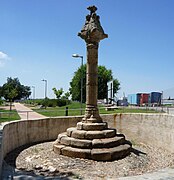
Rollo de Moraleja


Town twinning
A community partnership with the Portuguese city of Ovar has existed since 1996 .
![]()
Web links
Individual evidence
- ↑ Cifras oficiales de población resultantes de la revisión del Padrón municipal a 1 de enero . Population statistics from the Instituto Nacional de Estadística (population update).
- ↑ Consulta - Geminações de Cidades e Vilas. Retrieved August 4, 2019 .
Abadía | Abertura | Acebo | Acehúche | Aceituna | Ahigal | Alagón del Río | Albalá | Alcántara | Alcollarín | Alcuéscar | Aldea del Cano | La Aldea del Obispo | Aldeacentenera | Aldeanueva de la Vera | Aldeanueva del Camino | Aldehuela de Jerte | Alía | Aliseda | Almaraz | Almoharín | Arroyo de la Luz | Arroyomolinos | Arroyomolinos de la Vera | Baños de Montemayor | Barrado | Belvís de Monroy | Benquerencia | Berrocalejo | Berzocana | Bohonal de Ibor | Botija | Brozas | Cabañas del Castillo | Cabezabellosa | Cabezuela del Valle | Cabrero | Cáceres | Cachorrilla | Cadalso | Calzadilla | Caminomorisco | Campillo de Deleitosa | Campo Lugar | Cañamero | Cañaveral | Carbajo | Carcaboso | Carrascalejo | Casar de Cáceres | Casar de Palomero | Casares de las Hurdes | Casas de Don Antonio | Casas de Don Gómez | Casas de Millán | Casas de Miravete | Casas del Castañar | Casas del Monte | Casatejada | Casillas de Coria | Castañar de Ibor | Ceclavín | Cedillo | Cerezo | Cilleros | Collado | Conquista de la Sierra | Coria | Cuacos de Yuste | La Cumbre | Deleitosa | Descargamaría | Eljas | Escurial | Fresnedoso de Ibor | Galisteo | Garciaz | La Garganta | Garganta la Olla | Gargantilla | Gargüera | Garrovillas de Alconétar | Garvín | Gata | El Gordo | La Granja | Guadalupe | Guijo de Coria | Guijo de Galisteo | Guijo de Granadilla | Guijo de Santa Bárbara | Herguijuela | Hernán-Pérez | Herrera de Alcántara | Herreruela | Hervás | Higuera | Hinojal | Holguera | Hoyos | Huélaga | Ibahernando | Jaraicejo | Jaraíz de la Vera | Jarandilla de la Vera | Jarilla | Jerte | Ladrillar | Logrosán | Losar de la Vera | Madrigal de la Vera | Madrigalejo | Madroñera | Majadas | Malpartida de Cáceres | Malpartida de Plasencia | Marchagaz | Mata de Alcántara | Membrío | Mesas de Ibor | Miajadas | Millanes | Mirabel | Mohedas de Granadilla | Monroy | Montánchez | Montehermoso | Moraleja | Morcillo | Navaconcejo | Navalmoral de la Mata | Navalvillar de Ibor | Navas del Madroño | Navezuelas | Nuñomoral | Oliva de Plasencia | Palomero | Pasarón de la Vera | Pedroso de Acim | Peraleda de la Mata | Peraleda de San Román | Perales del Puerto | Pescueza | La Pesga | Piedras Albas | Pinofranqueado | Piornal | Plasencia | Plasenzuela | Portaje | Portezuelo | Pozuelo de Zarzón | Puerto de Santa Cruz | Rebollar | Riolobos | Robledillo de Gata | Robledillo de la Vera | Robledillo de Trujillo | Robledollano | Romangordo | Rosalejo | Ruanes | Salorino | Salvatierra de Santiago | San Martín de Trevejo | Santa Ana | Santa Cruz de la Sierra | Santa Cruz de Paniagua | Santa Marta de Magasca | Santiago de Alcántara | Santiago del Campo | Santibáñez el Alto | Santibáñez el Bajo | Saucedilla | Segura de Toro | Serradilla | Serrejón | Sierra de Fuentes | Talaván | Talaveruela de la Vera | Talayuela | Tejeda de Tiétar | Tiétar | Toril | Tornavacas | El Torno | Torre de Don Miguel | Torre de Santa María | Torrecilla de los Ángeles | Torrecillas de la Tiesa | Torrejón el Rubio | Torrejoncillo | Torremenga | Torremocha | Torreorgaz | Torrequemada | Trujillo | Valdastillas | Valdecañas de Tajo | Valdefuentes | Valdehúncar | Valdelacasa de Tajo | Valdemorales | Valdeobispo | Valencia de Alcántara | Valverde de la Vera | Valverde del Fresno | Viandar de la Vera | Vegaviana | Villa del Campo | Villa del Rey | Villamesías | Villamiel | Villanueva de la Sierra | Villanueva de la Vera | Villar de Plasencia | Villar del Pedroso | Villasbuenas de Gata | Zarza de Granadilla | Zarza de Montánchez | Zarza la Mayor | Zorita