Did Ali
| Did Ali | ||
|---|---|---|
| height | 655 m | |
| location | Ethiopia | |
| Coordinates | 13 ° 17 '2 " N , 41 ° 3' 47" E | |
|
|
||
| Type | Shield volcano | |
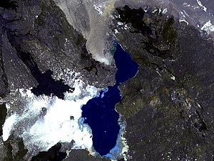
The Tat Ali is a shield volcano in Ethiopia , which is located in the so-called Tat-Ali area , east of Lake Afrera . It originated during the early Holocene . It consists of various types of rock. In the area around the volcano, cracks oriented from northwest to southeast have led to lava flows. The crevices northeast of Lake Afrera existed before the volcano was formed. The depression in the summit area is an area of fumarolic activity and is filled with basaltic lava. Borawli is located between Tat Ali and Afrera Lake .
Individual evidence
- ↑ Global Volcanism Program | Did Ali. Accessed August 4, 2019 .
- ↑ Carolina Pagli, Tim J. Wright, Cynthia J. Ebinger, Sang-Ho Yun, Johnson R. Cann: Shallow axial magma chamber at the slow-spreading Erta Ale Ridge . In: Nature Geoscience . tape 5 , no. 4 , April 2012, ISSN 1752-0894 , p. 284–288 , doi : 10.1038 / ngeo1414 ( nature.com [accessed August 4, 2019]).
- ^ Pierre Wiart, Clive Oppenheimer: Large magnitude silicic volcanism in north Afar: the Nabro Volcanic Range and Ma? Alalta volcano . In: Bulletin of Volcanology . tape 67 , no. 2 , February 2005, ISSN 0258-8900 , p. 99–115 , doi : 10.1007 / s00445-004-0362-x ( springer.com [accessed August 4, 2019]).

