Almaraz (Cáceres)
| Almaraz municipality | ||
|---|---|---|
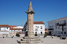
 Almaraz - town view
|
||
| coat of arms | Map of Spain | |

|
|
|
| Basic data | ||
| Autonomous Community : |
|
|
| Province : | Cáceres | |
| Comarca : | Campo Arañuelo | |
| Coordinates | 39 ° 49 ′ N , 5 ° 41 ′ W | |
| Height : | 270 msnm | |
| Area : | 33.91 km² | |
| Residents : | 1,744 (Jan 1, 2019) | |
| Population density : | 51.43 inhabitants / km² | |
| Postal code : | 10350 | |
| Municipality number ( INE ): | 10019 | |
| administration | ||
| Website : | Almaraz | |
Almaraz is a place and a municipality ( municipio ) with 1,744 inhabitants (as of January 1, 2019) in the province of Cáceres in the autonomous region of Extremadura in southwestern Spain .
location
The place Almaraz is located in a depression through which the Río Tajo flows south of the Sierra de Gredos and north of the Montes de Toledo almost 100 km (driving distance) northeast of the provincial capital Cáceres at an altitude of approx. 270 m . The place has a motorway exit on the Autovía A-5 . The climate is temperate to warm; Rain (approx. 400 mm / year) falls mainly in the winter half-year.
Population development
| year | 1857 | 1900 | 1950 | 2000 | 2017 |
| Residents | 746 | 986 | 1,048 | 1,557 | 1,651 |
Almaraz is one of the few smaller towns in the province of Cáceres whose population has grown since the 1950s, despite the mechanization of agriculture and the abandonment of small farms, which is mainly due to its location on the A-5 autovía and European route 90 .
economy
The area has hardly any arable land. The cultivation of wheat and other crops used to serve mainly for self-sufficiency ; In addition, there were many untreated areas due to the lack of water, which are, however, suitable for extensive livestock keeping (sheep and goats), even if in earlier centuries the herds in summer on drift paths ( cañadas ) to the higher mountain regions in central and northern Spain had to be driven. The Almaraz nuclear power plant is located on a reservoir built in the second half of the 20th century in the west of the municipality ; however, the community also invests in renewable energies .
history

Little is known about the early history of the Almaraz area. In Roman times a connecting route between the important Roman cities of Mérida ( Emerita Augusta ) , Talavera de la Reina ( Caesarobriga ) and Saragossa ( Caesaraugusta ) ran along here; In addition, a silver mine and a necropolis are proven. The Visigoths left hardly any traces. The place name comes from the Arabs or Moors ; However, there is no archaeological evidence. Mérida and the surrounding area were founded in 1230 by the Castilian - Leonese troops of Alfonso IX. Recaptured from the hands of the Moors ( reconquista ) and gradually settled by Christians from the north and refugees from Al-Andalus . In the 14th century, a regionally important manor (señorio) emerged .
Attractions
- Of the castle (Castillo de Almaraz) built in the 14th century on the eastern edge of the village , only the keep (torre del homenaje) remains .
- The exterior of the Iglesia de San Andrés Apóstol , built in the second quarter of the 16th century on the highest point of the town, shows a clear defensive character . The nave impresses with its joint painting .
- A court column (roller blind) from the 16th century with a hexagonal cross-section rises on a stepped base in the center of the village .
Web links
- Almaraz, sights - photos (spanish)
Individual evidence
- ↑ Cifras oficiales de población resultantes de la revisión del Padrón municipal a 1 de enero . Population statistics from the Instituto Nacional de Estadística (population update).
- ↑ Almaraz - climate tables
- ↑ Almaraz - population development
- ↑ Almaraz - History
- ^ Almaraz - Castillo
- ^ Almaraz - Castillo
- ↑ Almaraz Church

