Montánchez
| Montánchez municipality | ||
|---|---|---|
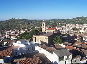
 Montánchez - View of the town with the Church of San Mateo
|
||
| coat of arms | Map of Spain | |

|
|
|
| Basic data | ||
| Autonomous Community : | Extremadura | |
| Province : | Cáceres | |
| Comarca : | Tierra de Montánchez | |
| Coordinates | 39 ° 14 ′ N , 6 ° 9 ′ W | |
| Height : | 715 msnm | |
| Area : | 112.66 km² | |
| Residents : | 1,682 (Jan 1, 2019) | |
| Population density : | 14.93 inhabitants / km² | |
| Postal code : | 10170 | |
| Municipality number ( INE ): | 10126 | |
| administration | ||
| Website : | Montánchez | |
Montánchez is a place and a municipality ( municipio ) with 1,232 inhabitants (as of 2019) in the west of the Spanish province Badajoz in the autonomous community of Extremadura .
location
The place Montánchez is about 55 km (driving distance) southeast of Cáceres at an altitude of about 715 m above sea level. d. The climate in winter is cool, but in summer it is warm to hot; the rather low amounts of precipitation (approx. 600 mm / year) fall - with the exception of the almost rainless summer months - distributed over the whole year.
Population development
| year | 1857 | 1900 | 1950 | 2000 | 2016 |
| Residents | 4,341 | 4,747 | 5,217 | 2.157 | 1,809 |
The significant population decline in the second half of the 20th century is essentially due to the mechanization of agriculture and the associated loss of jobs.
economy
While the surrounding area was largely agricultural for centuries, small traders, craftsmen and service providers of all kinds also settled in the village.
history
Various small prehistoric finds were made in the municipality; Celtic traces have not yet been discovered. The castle on the nearby castle hill is attributed to the Romans ; smaller finds from the Visigothic period are also available. The Moors conquered the region around the year 715. The first written mention of the place name comes from the year 1095, when the place and its castle belonged to the small kingdom ( taifa ) of the Aftasids of Badajoz . Around this time the Almoravids began to rule and later (1196) that of the Almohads . In 1230 Montanchez and the surrounding area were taken over by the troops of Alfonso IX. Recaptured by León (r. 1188–1230) for the Christians ( reconquista ) and given to the Santiagoorden for better defense . In the period that followed, the castle was the starting point for further territorial conquests by the knightly order. Since the 13th century, the city has been the center of a total of 14 villages (Comunidad de Villa y Tierra de Montanchez) .
Attractions
- The most important building of the small town is the castle (castillo) , whose present appearance dates from the time after the reconquest by the Christians. It consists of an outer wall ring and the actual castle with its former residential buildings and stables. Several plastered cisterns (aljibes) from the Moorish era were used for the water supply.
- The stone-faced walls of the church of San Mateo , stabilized by buttresses , were built in the late 17th century on the site of a previous medieval building. There are several baroque altars in the high-vaulted nave .
- There are several stone crosses (calvarios) and hermit chapels (ermitas) from the 16th to 18th centuries spread across the town .
Web links
Individual evidence
- ↑ Cifras oficiales de población resultantes de la revisión del Padrón municipal a 1 de enero . Population statistics from the Instituto Nacional de Estadística (population update).
- ↑ Montánchez - Map with altitude information
- ↑ Montánchez - climate tables
- ^ Montánchez - population development
- ↑ Montánchez - History
- ↑ Montánchez - Castle
- ^ Montánchez Church
- ↑ Montánchez - crosses etc.
- ↑ Montánchez - Hermit Chapels

