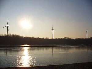
Mahndorfer See
| Mahndorfer See | ||
|---|---|---|

|
||
| Mahndorfer See | ||
| Geographical location | Southern edge of Bremen | |
| Places on the shore | Bremen | |
| Data | ||
| Coordinates | 53 ° 1 '47 " N , 8 ° 56' 34" E | |
|
|
||
| surface | 22.4 ha | |
| Maximum depth | 15 m | |
|
particularities |
Quarry pond |
|
The Mahndorfer See is a quarry pond in the south of Bremen with an area of 22.4 hectares and a maximum depth of 15 meters. The state border runs through the lake, the eastern bank belongs to the town of Achim in the Verden district , Lower Saxony .
Location and directions
The Mahndorfer See is located between the A1 motorway and Mahndorfer Heerstraße in the southeast of the city of Bremen . A small part of the area belongs to Lower Saxony . It can be reached by car via Mahndorfer Heerstraße. You can also travel by bus (line 38, 40/41, 44; stop at Mahndorf station) or by train (Mahndorf station). The view is dominated by ten wind turbines in the Mahndorfer Marsch .
history
The lake was created in 1961/62 during the construction of the A1 motorway. It got its current size by removing sand for the construction of the Mercedes plant in Bremen .
use
The Mahndorfer See serves as a bathing lake with a DLRG station from 1982. There are two beach areas with coarse-grained sand and three sunbathing areas. A forest extends between the lake and A1 , through which you can walk around the lake. Since the water is very poor in nutrients , it has a very good bathing quality.
There are two small bird protection islands in the lake , entry into which is prohibited. Together with the forest to the south, they form a nature reserve.
See also
- List of bodies of water in the Free Hanseatic City of Bremen
- List of lakes in Lower Saxony
- Mahndorfer March
Web links
