
Sierra Nevada (Spain)
| Sierra Nevada | |
|---|---|
 |
|
 Sierra Nevada |
|
| Highest peak | Mulhacén ( 3482 msnm ) |
| location | Iberian Peninsula :; Spain - Granada / Almería |
| part of | Betic Cordilleras |
| Coordinates | 37 ° N , 3 ° W |
| Type | Fold Mountains |
| Age of the rock | Alpidian phase (100–50 mya) |
The Sierra Nevada ( Spanish for "snow-capped mountains") is at 3482 msnm the highest mountain range on the Iberian Peninsula , which usually has a snow cap every year from November to May. It is located in southern Spain in the provinces of Granada and Almería in the autonomous region of Andalusia and is a 100 km long part of the Betic Cordillera . The core area of 86,208 hectares has been protected as the Sierra Nevada National Park since 1999 .
Location and landscape
The Sierra Nevada stretches in a west-east direction along part of the southern Mediterranean coast of Spain . Some of the steep slopes reach right up to the Mediterranean, such as in and around Almería .
The highest point is the Mulhacén ( 3482 m ), followed by the Pico del Veleta ( 3397 m ) and Alcazaba ( 3392 m ).
The meltwater of the Sierra Nevada supplies the surrounding area, including the greenhouse crops in Almería, the Vega of Granada and the cities of Granada and Almería with drinking water. The most famous mineral water brand in Spain, Lanjarón , also draws its water from a spring in the town of the same name in the Alpujarras , which form the south side of the mountains.
Surface shapes

The Sierra Nevada is a high mountain range . The vertical extension ranges from 1500 m to 3482 m (Pico Mulhacen, highest point in mainland Spain / the Iberian Peninsula). The Sierra Nevada thus has a morphological character that is typical of high mountains. Due to the height of the mountains, parts of the Sierra Nevada were glaciated in the Vistula glacial .
The most important manifestation of high mountains is the type of weathering of the surface material. So one speaks of frost debris weathering . This has its origin in the low temperatures prevailing in the high mountains. In the temperate to warm summer months, water can enter the fissures of rocks, which freezes in winter. As a result of the expansion when the state of aggregation changes, the rocks are shattered. The weathering thus produces a very rugged rock material. Due to the last icing phase, forms of glacial overprinting can be found in the Sierra Nevada. These forms include valley forms (U valley), forms of raised bogs, solifluctions and moraines.
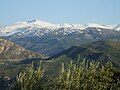
Sierra Nevada with the Pico del Veleta (view from the mountains of Quéntar )
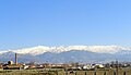
Sierra Nevada (view from Granada )

View of the southern foreshore

Sierra Nevada as seen from an airplane from the east


_4.JPG)

geology
|
|
||
| Summit (> 3000 m ) | Height (m) | |
| Mulhacén | 3482 m | |
| Pico del Veleta | 3393 m | |
| Alcazaba | 3371 m | |
| Cerro los Machos | 3324 m | |
| Puntal de Siete Lagunas | 3248 m | |
| Puntal de la Caldera | 3226 m | |
| Pico de Elorrieta | 3206 m | |
| Crestones Río Seco | 3198 m | |
| Loma Pelada | 3187 m | |
| Cerro Pelado | 3179 m | |
| Tajos de la Virgen | 3160 m | |
| Tosal del Cartujo | 3152 m | |
| Pico de La Atalaya | 3148 m | |
| Puntal de Vacares | 3143 m | |
| Cerro Rasero | 3139 m | |
| Tajos del Nevero | 3120 m | |
| Raspones Río Seco | 3120 m | |
| Tajos Altos | 3111 m | |
| Picón de Jeres | 3090 m | |
| Tajo de los Machos | 3088 m | |
| Cerrillo Redondo | 3058 m | |
| Juego de Bolos | 3018 m | |
| Pico del Caballo | 3013 m | |
The Betic Cordillera is a mountain range that was unfolded in the Alpidic orogeny by two convergent plate edges. The source material is Variscan . In the Sierra Nevada there are references to both components, alpine and Variscan material. The Betic Cordillera is characterized by a large occurrence of marine, Jurassic sedimentary rocks. Limes are predominant, as is the metamorphic secondary rock marble. A large number of marble quarries can be found in the mountainous regions of Andalusia.
The Betic Cordillera is divided into three parts, the southern Jurassic zone, dominated by maritime sedimentary rocks, the paleozoic, crystalline autochthonous central zone and the northern zone, which is also characterized by maritime sediments .
Mica schists are predominant in the Sierra Nevada itself . Mica schist is a metamorphic, schisty rock. The original rock is gneiss, a metamorphic overprinted intrusive rock with the same mineral composition as granite, but with an increased feldspar content of more than 20%.
The shape of the mountain range already suggests the abrupt change between the various rocks. The parts dominated by limestone are rugged and strongly characterized by erosion. The crystalline parts are rounded and flat.
climate
The Sierra Nevada is located in the Mediterranean region in a warm, winter-humid climate that is typical for this region. The mountain range of the Betic Cordillera that stretches along the coast has a function as a climatic divide, so its elevation acts as a barrier to the incoming air masses.
The mountains have typical mountain wind systems. The uphill wind increases significantly towards midday and leads to the formation of clouds and fog in humid air through condensation at cooler altitudes. The Sierra Nevada is an important supplier of water for the surrounding regions and especially the coastal areas.
Vegetation and vegetation levels
In the Sierra Nevada there is the typical Mediterranean situation that there is almost no primary tree population. If areas were afforested, this was done with fast-growing, undemanding species or the areas that were freed up are used for the cultivation of oil or nut trees. Nevertheless, there are some places where the vegetation and especially the change in vegetation with height can be observed.
The vegetation can be divided into five Mediterranean mountain levels. The lowest level, the Mediterranean level, extends to around 1600 m . Evergreen deciduous trees are typical , here the holm oak ( Quercus ilex ) predominates . The next stage is dominated by deciduous trees. The winter temperatures drop so far at this stage that evergreen vegetation cannot develop. A typical representative of this level is the Pyrenees oak ( Quercus pyrenaica ). The oak forests were partly converted into chestnut groves. From around 1800 m a transition step made of coniferous wood forms until the tree line is reached. The Scots pine here is considered to be the southernmost in Europe. The tree line varies depending on the exposure of the slope (and anthropogenic influences). The following submontane stage is characterized by dwarf shrubs, predominantly juniper. The wind exposure is an important location factor here. In the montane zone, alpine grasses form mats that can withstand extreme weather conditions.
Mountain sports
Via the village of Pradollano (also known as Sol y Nieve ) you can reach the summit of Pico del Veleta via the highest country road in Europe. With your own car you can only drive up to the Hoya de la Mora ( 2500 m ). If you want to go up to Veleta, you have to continue on foot, by bike or by bus from the national park. Sol y Nieve is an artificially created winter sports resort where the 1995 Alpine World Ski Championships were to take place. But since there was a lack of snow in the Sierra Nevada that year, it was postponed to 1996 and held as the 1996 Alpine World Ski Championships. The 2000 Mountain Bike World Championships also took place here . Other major events were the Winter Universiade 2015 and in 2017 the World Championships in freestyle skiing and snowboarding , for which one of the largest snow parks in Europe was built in 2013 . The game show Showdown - The Desert Challenge has been filmed in the Sierra Nevada since 2018 .
Refuges
- Refugio Poqueira ( 2500 m )
- Refugio Postero Alto ( 1990 m )
literature
- Francisco Pérez Raya, Joaquín Molero Mesa, Francisco Valle Tendero: Parque Natural de Sierra Nevada. Paisaje, fauna, flora, itinerarios ", Ed. Rueda, Madrid 1992, ISBN 84-7207-067-0
- Pablo Prieto Fernández: Flora de la Tundra de Sierra Nevada , Ed. Universidad de Granada, ISBN 84-600-1810-5
- Aurelio del Castillo, Antonio del Castillo: Sierra Nevada: Guía de Montaña , Ed. Penibética, 2003, ISBN 84-932022-3-1
Web links
- Photos from the Sierra Nevada
- Official homepage of the ski area
- Sierra Nevada Website about nature, landscape and hiking opportunities in the Sierra Nevada
Individual evidence
- ↑ Sierra Nevada to build one of Europe's longest slopestyle lines ( Memento of the original from January 15, 2014 in the Internet Archive ) Info: The archive link was inserted automatically and has not yet been checked. Please check the original and archive link according to the instructions and then remove this notice. on the FIS website of November 8, 2013, accessed on June 6, 2014 (English).