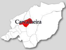
Carvalheira
| Carvalheira | ||||||
|---|---|---|---|---|---|---|
|
||||||
| Basic data | ||||||
| Region : | Norte | |||||
| Sub-region : | Cávado | |||||
| District : | Braga | |||||
| Concelho : | Terras de Bouro | |||||
| Coordinates : | 41 ° 45 ′ N , 8 ° 14 ′ W | |||||
| Residents: | 386 (as of June 30, 2011) | |||||
| Surface: | 9.05 km² (as of January 1, 2010) | |||||
| Population density : | 43 inhabitants per km² | |||||
| Postal code : | 4840-040 | |||||
| politics | ||||||
| Mayor : | Aida Filipa Moreira da Silva (independent candidate) | |||||
| Address of the municipal administration: | Junta de Freguesia de Carvalheira Assento 4840-040 Carvalheira |
|||||
Carvalheira is a municipality in northern Portugal . It is located in the Peneda-Gerês National Park . The Rio Homem flows through the municipality.
Carvalheira is one of the 32 glyphosate-free municipalities in Portugal (as of March 2018).
history
It is possible that the place we see today was created during the medieval Reconquista . In 1590 there were already several religious buildings here.
Carvalheira has always been an independent municipality in the Terras de Bouro district until it was incorporated into the Amares district in 1985 . Since 1989 the parish has belonged again to the district of Terras de Bouro.
Attractions
The nature in the Peneda-Gerês National Park is the main tourist attraction in the region. Hiking trails run through the area.
Several stone bridges cross watercourses in the municipal area, in particular the listed Ponte da Carvalheira and Ponte de Cabaninhas bridges from the 17th century.
The pilgrimage site of Santuário de Bom Jesus de Mós , completed in 1912, is also one of the parish's architectural monuments.
Education and culture
The community has a primary school and a kindergarten.
Community life is largely determined by the sports and leisure club Associação Desportiva e Recreativa de Carvalheira , the musical association Banda Musical de Carvalheira and the folk dance group Grupo Folclórico de Carvalheira , etc. a.
administration
Carvalheira is a parish ( freguesia ) in the district ( concelho ) of Terras de Bouro , in the district of Braga . The municipality has an area of 9.1 km² and has 386 inhabitants (as of June 30, 2011).
The municipality is made up of six localities:
- Assento (actual main town)
- Cabaninhas
- Ervedeiros
- Infesta
- Paredes
- Quintão
Population development
The community is characterized by migration and aging.
| Population in the municipality of Carvalheira (1864–2011) | ||||||||||||||
|---|---|---|---|---|---|---|---|---|---|---|---|---|---|---|
| 1864 | 1878 | 1890 | 1900 | 1911 | 1920 | 1930 | 1940 | 1950 | 1960 | 1970 | 1981 | 1991 | 2001 | 2011 |
| 616 | 661 | 577 | 568 | 672 | 670 | 676 | 722 | 852 | 734 | 606 | 553 | 481 | 448 | 386 |
economy
There are farms, construction, trade and catering businesses in the municipality. In addition, traditional handicrafts are produced here.
Web links
- Map of the Freguesia Carvalheira at the Instituto Geográfico do Exército
- Website on the municipality of Carvalheira at the Terras De Bouro district administration
- Entry on Carvalheira in the Mapas de Portugal
Individual evidence
- ↑ a b www.ine.pt - indicator resident population by place of residence and sex; Decennial in the database of the Instituto Nacional de Estatística
- ↑ Overview of code assignments from Freguesias on epp.eurostat.ec.europa.eu
- ↑ Article in the members' newspaper of the environmental protection organization Quercus , issue No. 84 (March 2018), page 21
- ↑ Portrait of the municipality of Carvalheira at the district administration of Terras de Bouro, accessed on April 13, 2018
- ^ Entry of the Ponte da Carvalheira in the Portuguese list of monuments SIPA, accessed on April 13, 2018
- ^ Entry of the Ponte da Carvalheira in the Portuguese list of monuments SIPA, accessed on April 13, 2018
- ^ Entry of the Santuário de Bom Jesus de Mós in the Portuguese list of monuments SIPA, accessed on April 13, 2018


