Póvoa de Lanhoso
| Póvoa de Lanhoso | ||||||
|---|---|---|---|---|---|---|
|
||||||
| Basic data | ||||||
| Region : | Norte | |||||
| Sub-region : | Ave | |||||
| District : | Braga | |||||
| Concelho : | Póvoa de Lanhoso | |||||
| Coordinates : | 41 ° 35 ′ N , 8 ° 17 ′ W | |||||
| Residents: | 5048 (as of June 30, 2011) | |||||
| Surface: | 5.7 km² (as of January 1, 2010) | |||||
| Population density : | 886 inhabitants per km² | |||||
| Postal code : | 4830-513 | |||||
| politics | ||||||
| Address of the municipal administration: | Junta de Freguesia de Póvoa de Lanhoso Av de Lanhoso, 1494 4830-349 Lanhoso |
|||||
| Website: | www.jf-lanhoso.pt | |||||
| County of Póvoa de Lanhoso | ||||||
|
||||||
| Residents: | 21,918 (as of June 30, 2011) | |||||
| Surface: | 134.66 km² (as of January 1, 2010) | |||||
| Population density : | 163 inhabitants per km² | |||||
| Number of municipalities : | 22nd | |||||
| administration | ||||||
| Administration address: | Câmara Municipal de Póvoa de Lanhoso Av. da República 4830-513 Póvoa de Lanhoso |
|||||
| President of the Câmara Municipal: | Manuel Baptista ( PSD ) | |||||
| Website: | www.mun-planhoso.pt | |||||
Póvoa de Lanhoso is a small town ( Vila ) and a district ( Concelho ) in Portugal with 5048 inhabitants (as of June 30, 2011).
history
Theresa of Castile , mother of D.Afonso Henriques , who waged war against her, barricaded herself in the castle of Lanhoso . The Treaty of Lanhoso negotiated between mother and son was one of the stages in the later founding of the Kingdom of Portugal , of which D.Afonso Henriques became King in 1139.
The town received its first city rights ( Foral ) in 1292 by King D Dinis , which were renewed by King Manuel I in 1514 .
administration
circle
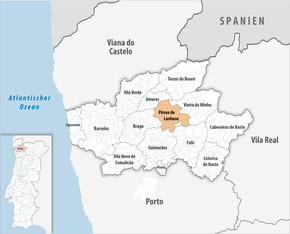
Póvoa de Lanhoso is the seat of a district of the same name. The neighbors are Amares , Vieira do Minho , Fafe , Guimarães and Braga .
With the regional reform in September 2013 , several municipalities were merged to form new municipalities, so that the number of municipalities decreased from 29 to 22.
The following municipalities ( Freguesias ) are in the Póvoa de Lanhoso district.
| local community | Population (2011) |
Area km² |
Density of population / km² |
LAU code |
|---|---|---|---|---|
| Águas Santas e Moure | 659 | 3.91 | 168 | 030930 |
| Calvos e Frades | 753 | 8.72 | 86 | 030931 |
| Campos e Louredo | 1,485 | 5.06 | 293 | 030932 |
| Covelas | 416 | 2.91 | 143 | 030906 |
| Esperança e Brunhais | 652 | 8.21 | 79 | 030933 |
| Ferreiros | 416 | 4.40 | 95 | 030908 |
| Fonte Arcada e Oliveira | 1,672 | 11.06 | 151 | 030934 |
| Galegos | 543 | 2.94 | 185 | 030912 |
| Garfe | 1,000 | 5.44 | 184 | 030913 |
| Geraz do Minho | 546 | 4.84 | 113 | 030914 |
| Lanhoso | 720 | 6.06 | 119 | 030915 |
| Monsul | 770 | 3.28 | 235 | 030917 |
| Póvoa de Lanhoso | 5,048 | 5.70 | 885 | 030919 |
| Rendufinho | 736 | 8.37 | 88 | 030921 |
| Santo Emilião | 926 | 2.14 | 433 | 030922 |
| Sao João de Rei | 401 | 5.46 | 73 | 030923 |
| Serzedelo | 719 | 10.06 | 71 | 030924 |
| Sobradelo da Goma | 794 | 10.12 | 78 | 030925 |
| Taíde | 1,613 | 6.67 | 242 | 030926 |
| Travassos | 698 | 4.64 | 150 | 030927 |
| Verim, Friande e Ajude | 736 | 10.09 | 73 | 030935 |
| Vilela | 615 | 4.58 | 134 | 030929 |
| County of Póvoa de Lanhoso | 21,918 | 134.66 | 163 | 0309 |
Population development
| Population in the Póvoa de Lanhoso district (1801–2011) | |||||||||
|---|---|---|---|---|---|---|---|---|---|
| 1801 | 1849 | 1900 | 1930 | 1960 | 1981 | 1991 | 2001 | 2011 | |
| 8084 | 9585 | 16,939 | 19,178 | 22,033 | 21.092 | 21,516 | 22,772 | 21,895 | |
Municipal holiday
- 19th March
Town twinning
-
 France : Neuves-Maisons (since 1987)
sons and daughters of the town
- Gonçalo Sampaio (1865–1937), botanist
- Agostinho Oliveira (* 1947), football player and coach
Web links
Individual evidence
- ↑ www.ine.pt - indicator resident population by place of residence and sex; Decennial in the database of the Instituto Nacional de Estatística
- ↑ a b Overview of code assignments from Freguesias on epp.eurostat.ec.europa.eu
- ↑ www.ine.pt - indicator resident population by place of residence and sex; Decennial in the database of the Instituto Nacional de Estatística
- ↑ www.verportugal.net , accessed January 30, 2013
- ^ Publication of the administrative reorganization in the Diário da República gazette of January 28, 2013, accessed on March 16, 2014
- ↑ www.anmp.pt , accessed January 30, 2013


