Marco de Canaveses
| Marco de Canaveses | ||||||
|---|---|---|---|---|---|---|
|
||||||
| Basic data | ||||||
| Region : | Norte | |||||
| Sub-region : | Tâmega e Sousa | |||||
| District : | postage | |||||
| Concelho : | Marco de Canaveses | |||||
| Coordinates : | 41 ° 11 ′ N , 8 ° 9 ′ W | |||||
| Residents: | 53,450 (as of June 30, 2011) | |||||
| Surface: | 201.9 km² (as of January 1, 2010) | |||||
| Population density : | 265 inhabitants per km² | |||||
| Marco de Canaveses county | ||||||
|
||||||
| Residents: | 53,450 (as of June 30, 2011) | |||||
| Surface: | 201.9 km² (as of January 1, 2010) | |||||
| Population density : | 265 inhabitants per km² | |||||
| Number of municipalities : | 16 | |||||
| administration | ||||||
| Administration address: | Câmara Municipal de Marco de Canaveses Largo Sacadura Cabral 4630-219 Marco de Canaveses |
|||||
| President of the Câmara Municipal: | Dr. Manuel Moreira ( PSD ) | |||||
| Website: | www.cm-marco-canaveses.pt | |||||
Marco de Canaveses is a city ( Cidade ) in northern Portugal . The church Igreja de Santa Maria de Fornos by the internationally renowned architect Álvaro Siza Vieira, completed in 1996, became famous .
history
Tombs and other finds show that Canaveses has been settled since the Neolithic Age . The archaeological site of a local Roman settlement, Tongóbriga, dates from Roman times .
The present place was probably created during the settlement policy after the Reconquista in the 12th century. The first city administrator of the independent administrative district Canaveses was Mendo Gil . In 1384 King D. João I gave the area to João Rodrigues Pereira , a relative of Nuno Álvares Pereira . After the reign of João I, the area fell back to the crown.
In the course of the administrative reforms after the Liberal Revolution in 1822 , the Canaveses district was dissolved and Soalhães was incorporated , before the Marco de Canaveses district was created in 1852 by reorganization. For this purpose, the former districts of Benviver, Canaveses, Soalhães, Portocarreiro, parts of the district of Gouveia, and Santa Cruz de Riba Tâmega were combined.
In 1993 the previous small town ( Vila ) was elevated to a town ( Cidade ).
administration
The circle
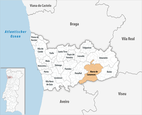
Marco de Canaveses is the seat of a district of the same name ( concelho ) in the Porto district . On June 30, 2011 the district had 53,450 inhabitants on an area of 201.9 km².
The neighboring districts are (starting clockwise in the north): Amarante , Baião , Cinfães , Castelo de Paiva and Penafiel .
With the regional reform in September 2013, several municipalities were merged into new municipalities, so that the number of municipalities decreased from 31 to 16.
The following municipalities ( Freguesias ) are in the Marco de Canaveses district:
| local community | Population (2011) |
Area km² |
Density of population / km² |
LAU code |
|---|---|---|---|---|
| Alpendorada, Várzea e Torrão | 8,485 | 16.82 | 504 | 130732 |
| Avessadas e rosém | 1,467 | 11.14 | 132 | 130733 |
| Banho e Carvalhosa | 1,276 | 4.91 | 260 | 130704 |
| Bem Viver | 3,877 | 9.59 | 404 | 130734 |
| Constance | 1,626 | 4.80 | 339 | 130705 |
| Livração | 2,083 | 4.67 | 446 | 130735 |
| Marco | 11,014 | 17.39 | 633 | 130736 |
| Paredes de Viadores e Manhuncelos | 1,775 | 13.12 | 135 | 130737 |
| Penhalonga e Paços de Gaiolo | 2,924 | 18.14 | 161 | 130738 |
| Sande e São Lourenço | 2,869 | 12.62 | 227 | 130739 |
| Soalhães | 3,682 | 24.06 | 153 | 130722 |
| Sobretâmega | 1,132 | 2.84 | 399 | 130723 |
| Taboo | 1,375 | 6.80 | 202 | 130724 |
| Várzea, Aliviada e Folhada | 2,771 | 23.19 | 120 | 130740 |
| Vila Boa de Quires e Maureles | 3,854 | 19.33 | 199 | 130741 |
| Vila Boa do Bispo | 3,240 | 12.48 | 260 | 130730 |
| Marco de Canaveses county | 53,450 | 201.90 | 265 | 1307 |
Population development
| Population in the district of Marco de Canaveses (1864–2011) | ||||||||
|---|---|---|---|---|---|---|---|---|
| 1864 | 1900 | 1930 | 1960 | 1981 | 1991 | 2001 | 2011 | |
| 23,820 | 28,188 | 32,354 | 39,270 | 46.131 | 48.133 | 52,419 | 53,569 | |
Municipal holiday
- September 8th
Town twinning
-
 Saint-Georges-lès-Baillargeaux in the Vienne department , France (since 1994)
 -
 Príncipe on the island of Príncipe , São Tomé and Príncipe (since 1998)
traffic
Marco Canaveses, with its train station just outside, is on the Linha do Douro railway line .
The city is connected to the A4 motorway , which runs 13 km to the north, via the N211 national road .
Regional private bus routes ensure local public transport . To this end, the city administration has set up a ride-sharing system called Marco à boleia (Marco per hitchhiker). Registered users receive an identity card and can arrange car-sharing opportunities online according to the principle of a car-sharing agency.
sons and daughters of the town
- João Martins de Soalhães († 1325), Bishop of Lisbon, Archbishop of Braga
- João Manuel Alexandrino de Vasconcelos (1787–1857), lawyer and politician
- Gaspar Pinto de Magalhães e Aguiar (1831–1922), lawyer, politician and noble landowner
- António Pinto de Magalhães Aguiar (1834-?), Mathematician and philosopher
- Adriano António Canavarro Crispiniano da Fonseca (1884–1979), lawyer and politician
- Carmen Miranda (1909–1955), Brazilian-American singer and actress, was considered the highest paid actress in the world in 1946
- David de Sousa (1911–2006), Bishop of Funchal, Archbishop of Évora
- Carlos de Azeredo (* 1930), officer of the Carnation Revolution , last governor of Madeira before the establishment of the autonomous region
- Belmiro de Azevedo (1938–2017), entrepreneur, President of the Sonae Group, at times richest Portuguese
- António José da Rocha Couto (* 1952), Bishop of Lamego
- Serafim Vieira (* 1966), racing cyclist
- Marcio Vieira (* 1984), Andorran football player
- Gonçalo Cardoso (* 2000), Portuguese football player
Web links
Individual evidence
- ↑ a b c www.ine.pt - indicator resident population by place of residence and sex; Decennial in the database of the Instituto Nacional de Estatística
- ↑ a b Overview of code assignments from Freguesias on epp.eurostat.ec.europa.eu
- ↑ www.verportugal.net , accessed December 11, 2013
- ↑ Publication of the administrative reorganization in the Diário da República law gazette of January 28, 2013 (PDF), accessed on March 16, 2014
- ↑ www.anmp.pt , accessed December 28, 2013
- ↑ site to Marco à boleia on the website of the City Council, accessed on 28 December 2013


