Saint-Georges-lès-Baillargeaux
| Saint-Georges-lès-Baillargeaux | ||
|---|---|---|

|
|
|
| region | Nouvelle-Aquitaine | |
| Department | Vienne | |
| Arrondissement | Poitiers | |
| Canton | Jaunay clan | |
| Community association | Grand Poitiers | |
| Coordinates | 46 ° 40 ′ N , 0 ° 24 ′ E | |
| height | 61-143 m | |
| surface | 33.9 km 2 | |
| Residents | 4,168 (January 1, 2017) | |
| Population density | 123 inhabitants / km 2 | |
| Post Code | 86130 | |
| INSEE code | 86222 | |
| Website | www.saint-georges-les-baillargeaux.fr | |
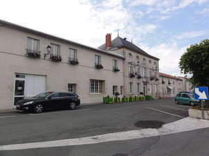
 School and town hall of Saint-Georges-lès-Baillargeaux |
||
Saint-Georges-lès-Baillargeaux is a French village with 4168 inhabitants (as of January 1 2017) in the department of Vienne in the region Nouvelle-Aquitaine . It is located in the Arrondissement of Poitiers and is the capital of the canton of Saint-Georges-lès-Baillargeaux .
geography
Saint-Georges-lès-Baillargeaux is located on the Clain River about ten kilometers north-northeast of Poitiers . Saint-Georges-lès-Baillargeaux is surrounded by the neighboring communities of Dissay in the north, Bonneuil-Matours in the east, La Chapelle-Moulière in the southeast, Montamisé in the south, Chasseneuil-du-Poitou in the southwest and Jaunay-Clan in the west.
Demographics
| year | 1962 | 1968 | 1975 | 1982 | 1990 | 1999 | 2006 | 2017 |
|---|---|---|---|---|---|---|---|---|
| Residents | 1,506 | 1,542 | 2,050 | 2,447 | 2,858 | 3.176 | 3,626 | 4,168 |
Attractions
- Saint-Georges church
- Aillé dolmen, historic monument since 1932
- Vayres Castle with park from the 15th century, with alterations from the 17th century, Monument historique since 1959 (Park since 1966 Monument historique)
Parish partnership
- Marco de Canaveses , Porto District, Portugal, since 1994
Web links
Commons : Saint-Georges-lès-Baillargeaux - Collection of images, videos and audio files

