
Ayron
| Ayron | ||
|---|---|---|
|
||
| region | Nouvelle-Aquitaine | |
| Department | Vienne | |
| Arrondissement | Poitiers | |
| Canton | Vouneuil-sous-Biard | |
| Community association | Haut-Poitou | |
| Coordinates | 46 ° 40 ′ N , 0 ° 5 ′ E | |
| height | 117-169 m | |
| surface | 28.3 km 2 | |
| Residents | 1,138 (January 1, 2017) | |
| Population density | 40 inhabitants / km 2 | |
| Post Code | 86190 | |
| INSEE code | 86017 | |
| Website | http://www.ayron.fr/ | |

Ayron is a French commune with 1,138 inhabitants (as of January 1 2017) in the department of Vienne in the region Nouvelle-Aquitaine . Ayron belongs to the Arrondissement of Poitiers and the canton of Vouneuil-sous-Biard (until 2015: canton of Vouillé ). The inhabitants are called Ayronais .
geography
Ayron is about 20 kilometers west-northwest of Poitiers on the Vendelogne River . Ayron is surrounded by the neighboring communities Chalandray in the north and west, Cherves in the north, Maillé in the northeast, Chiré-en-Montreuil in the east and southeast, Latillé in the south and Vasles in the west and southwest.
The national route 149 runs through the municipality .
Population development
| year | 1962 | 1968 | 1975 | 1982 | 1990 | 1999 | 2006 | 2013 |
| Residents | 759 | 714 | 625 | 820 | 899 | 991 | 1,084 | 1,165 |
| Source: Cassini and INSEE | ||||||||
Attractions
- Saint-Gervais-Saint-Protais church on foundations from the 5th / 6th centuries Century erected
- Ayron Castle from the 15th / 16th centuries Century, monument historique since 1999
- Wash house from 1850
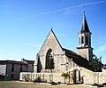
Saint-Gervais-Saint-Protais church

Ayron Castle

Wash house


Web links
Commons : Ayron - collection of pictures, videos and audio files