Saint-Julien-l'Ars
| Saint-Julien-l'Ars | ||
|---|---|---|

|
|
|
| region | Nouvelle-Aquitaine | |
| Department | Vienne | |
| Arrondissement | Poitiers | |
| Canton | Chasseneuil-du-Poitou | |
| Community association | Grand Poitiers | |
| Coordinates | 46 ° 34 ' N , 0 ° 31' E | |
| height | 104-130 m | |
| surface | 18.46 km 2 | |
| Residents | 2,660 (January 1, 2017) | |
| Population density | 144 inhabitants / km 2 | |
| Post Code | 86800 | |
| INSEE code | 86226 | |
| Website | http://www.saintjulienlars.fr/ | |
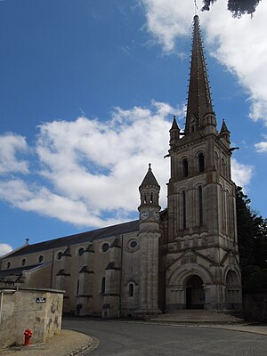
 Saint-Julien church |
||
Saint-Julien-l'Ars is a French village with 2,660 inhabitants (as of January 1 2017) in the department of Vienne in the region Nouvelle-Aquitaine ; it belongs to the Arrondissement of Poitiers and the canton of Chasseneuil-du-Poitou (until 2015: canton of Saint-Julien-l'Ars ). The inhabitants are called Sancto-Julianais .
geography
The place is about twelve kilometers east of Poitiers . Saint-Julien-l'Ars is surrounded by the neighboring communities of Lavoux in the north, Jardres in the east, Pouillé in the south-east, Tercé in the south and south-east, Savigny-Léscault in the south and south-west, Mignaloux-Beauvoir in the south-west and Sèvres-Anxaumont in the west.
The former route nationale 151 (today's D951) runs through the municipality .
history
During the Second World War, a German internment camp was located here from September 1941, which was used as a prisoner-of-war camp for German officers after it was liberated by the Allies.
Population development
| year | 1962 | 1968 | 1975 | 1982 | 1990 | 1999 | 2006 | 2012 |
|---|---|---|---|---|---|---|---|---|
| Residents | 1,180 | 1,237 | 1,436 | 1,724 | 1,903 | 2,061 | 2,170 | 2,447 |
Attractions
- Saint-Julien church
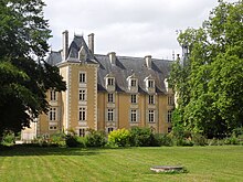
- Saint-Julien Castle, a historic monument since 1930
Personalities
- Yvonne Brothier (1889–1967), opera singer (soprano)

