Vila Nova de Gaia
| Vila Nova de Gaia | ||||||
|---|---|---|---|---|---|---|
|
||||||
| Basic data | ||||||
| Region : | Norte | |||||
| Sub-region : | Porto metropolitan area | |||||
| District : | postage | |||||
| Concelho : | Vila Nova de Gaia | |||||
| Coordinates : | 41 ° 8 ′ N , 8 ° 37 ′ W | |||||
| Residents: | 302,298 (as of June 30, 2011) | |||||
| Surface: | 168.47 km² (as of January 1, 2010) | |||||
| Population density : | 1794 inhabitants per km² | |||||
| Postal code : | 4400 | |||||
| Vila Nova de Gaia county | ||||||
|
||||||
| Residents: | 302,298 (as of June 30, 2011) | |||||
| Surface: | 168.47 km² (as of January 1, 2010) | |||||
| Population density : | 1794 inhabitants per km² | |||||
| Number of municipalities : | 15th | |||||
| administration | ||||||
| Administration address: | Câmara Municipal Rua Álvares Cabral 4400-017 VN Gaia |
|||||
| President of the Câmara Municipal: | Eduardo Vitor Rodrigues ( PS ) | |||||
| Website: | www.cm-gaia.pt | |||||
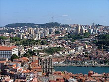
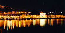
Vila Nova de Gaia [ ˈvilɐ ˈnɔvɐ dɯ ˈɡaiɐ ] (short: Gaia ) is a city in Portugal . It is located on the Atlantic coast on the south bank of the Douro which flows there, opposite Porto on the other bank of the river. Vila Nova de Gaia has about 180,000 inhabitants and is the center of port wine production . The promenades, bars and restaurants on the Cais de Gaia are next to the port wine cellars the most important tourist destination of Vila Nova de Gaia.
Vila Nova de Gaia is the seat of a district of the same name, which with around 300,000 inhabitants is the third largest district in Portugal after Lisbon and Sintra .
history
In 1255 the settlement of Vila de Gaia became an edict from King Alfonso III. first mentioned in a document. In 1288 a settlement called Vila Nova de Rei was mentioned, of which only the name Vila Nova remained. The edict of King Manuel I in 1518 gave the villages of Vila Nova e Gaia self-government rights. In the 18th century, the settlement of foreign traders in the context of port wine production made the place a rapidly growing settlement of seafarers, craftsmen and business people. On June 20, 1834, the two places united to form the community of Vila Nova de Gaia, which still exists today . By edict of Queen Maria II , Vila Nova de Gaia received city rights in 1841.
Economy and Transport
An important economic factor in Vila Nova de Gaia are the extensive halls of the port wine producers on the south bank of the Douro , in which the port wine ages for years or even decades. Tourism has gained in importance, especially in the port wine cellars and the developed waterfront.
Local public transport is operated by Metro do Porto and Sociedade de Transportes Colectivos do Porto . The suburbs are served by the CP Urbanos do Porto . The Teleférico de Gaia connects the Cais de Gaia with the upper floor of the Ponte Dom Luís I and the monastery of Serra do Pilar .
Vila Nova de Gaia or the Vila Nova de Gaia train station is located on Linha do Norte .
Sports
The men's team of Valadares Gaia FC , founded on June 17, 2011, has been playing in the first division of the Porto district championship since 2014, and that of women in the top division of the national championship of Portugal.
Vila Nova de Gaia county
Neighboring areas
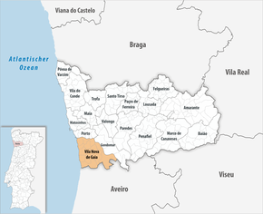
The neighboring areas are (starting clockwise in the north): Porto , Gondomar , Santa Maria da Feira and Espinho .
| postage | Gondomar | |
| ( Atlantic Ocean ) |

|
Gondomar |
| Espinho | Santa Maria da Feira |
The following municipalities ( freguesias ) are in the district of Vila Nova de Gaia:
| local community | Population (2011) |
Area km² |
Density of population / km² |
LAU code |
|---|---|---|---|---|
| Arcozelo | 14,352 | 8.50 | 1,689 | 131701 |
| Avintes | 11,497 | 8.82 | 1,303 | 131702 |
| Canelas | 13,459 | 6.90 | 1,950 | 131703 |
| Canidelo | 27,769 | 8.93 | 3,109 | 131704 |
| Grijó e Sermonde | 11,938 | 12.99 | 919 | 131725 |
| Gulpilhares e Valadares | 22,019 | 10.61 | 2,075 | 131726 |
| Madalena | 10,040 | 4.69 | 2.141 | 131709 |
| Mafamude e Vilar do Paraíso | 52,422 | 10.57 | 4,957 | 131727 |
| Oliveira do Douro | 22,383 | 7.54 | 2,970 | 131712 |
| Pedroso e Seixezelo | 20,426 | 20.88 | 978 | 131728 |
| Sandim, Olival, Lever e Crestuma | 17.168 | 34.16 | 503 | 131729 |
| Santa Marinha e São Pedro da Afurada | 33,714 | 6.91 | 4,876 | 131730 |
| Sao Félix da Marinha | 12,706 | 7.93 | 1,602 | 131717 |
| Serzedo e Perosinho | 14,250 | 11.97 | 1,191 | 131731 |
| Vilar de Andorinho | 18,155 | 7.07 | 2,570 | 131723 |
| Vila Nova de Gaia county | 302.298 | 168.47 | 1,794 | 1317 |

Population development
| Population in the district of Vila Nova de Gaia (1801–2011) | ||||||||
|---|---|---|---|---|---|---|---|---|
| 1801 | 1849 | 1900 | 1930 | 1960 | 1981 | 1991 | 2001 | 2011 |
| 24,675 | 43,454 | 74,072 | 102,950 | 157.357 | 226,331 | 248,565 | 288,749 | 302.296 |
Town twinning
-
 Mozambique : Manhiça , Maputo Province (since 2000)
 -
 Spain : Zamora , Zamora Province (since 2005)
 -
 Brazil : Cotia , State of São Paulo
Personalities
|
|
Web links
- www.cm-gaia.pt (Portuguese)
Individual evidence
- ↑ a b www.ine.pt - indicator resident population by place of residence and sex; Decennial in the database of the Instituto Nacional de Estatística
- ↑ a b Overview of code assignments from Freguesias on epp.eurostat.ec.europa.eu
- ↑ List of partnerships Vila Nova de Gaias , Association of Portuguese District Governments (ANMP), accessed on January 5, 2019


