
Póvoa de Varzim
| Póvoa de Varzim | ||||||
|---|---|---|---|---|---|---|
|
||||||
| Basic data | ||||||
| Region : | Norte | |||||
| Sub-region : | Porto metropolitan area | |||||
| District : | postage | |||||
| Concelho : | Póvoa de Varzim | |||||
| Coordinates : | 41 ° 23 ′ N , 8 ° 46 ′ W | |||||
| Residents: | 28,413 (as of June 30, 2011) | |||||
| Surface: | 4.74 km² (as of January 1, 2010) | |||||
| Population density : | 5994 inhabitants per km² | |||||
| Postal code : | 4490 | |||||
| politics | ||||||
| Mayor : | Aires Henrique do Couto Pereira | |||||
| Address of the municipal administration: | Junta de Freguesia 4490 Póvoa de Varzim |
|||||
| Póvoa de Varzim district | ||||||
|
||||||
| Residents: | 63,408 (as of June 30, 2011) | |||||
| Surface: | 82.22 km² (as of January 1, 2010) | |||||
| Population density : | 771 inhabitants per km² | |||||
| Number of municipalities : | 7th | |||||
| administration | ||||||
| Administration address: | Câmara Municipal Praça do Almada 5A 4490-438 Póvoa de Varzim |
|||||
| President of the Câmara Municipal: | Aires Henrique do Couto Pereira ( PSD ) | |||||
| Website: | www.cm-pvarzim.pt | |||||


Póvoa de Varzim [ ˈpɔvuɐ dɯ vɐɾˈzĩ ] is a city in northern Portugal .

history

Excavations of the Cividade Terroso ( Castro culture , approx. 900 BC)
|
Finds show a prehistoric settlement of the area, especially the excavations in Terroso. The place was first officially mentioned in 953 as Villa Eurazini . The name goes back to a former lord of the lands named Varazim, whose exact identity and lifetime are unknown. The area was sought after for agricultural production and especially for fishing. So the knight D. Lourenço Fernandes made a special effort to colonize the lands that promised high income here. His property was in the northern area, known as Vila Velha in the 14th century, and most of which fell to the Knights of the Hospitaller Order . This area was listed as Varazim dos Cavaleiros (Varazim the Knights). The southern parts, on the other hand, were under the control of the crown, which received significant tax income, especially from fishing, which fueled the desires and attempts at appropriation of the regional nobility. In order to end the disputes over property, the crown united large parts of the territories and henceforth led them under the name Varazim . King D. Dinis gave Varazim town rights in 1308 on condition that a functioning village (Póvoa) be established here.
In 1514 King D. Manuel I renewed the town charter . At the time, the small district town had barely 500 inhabitants, but experienced a steady boom with the onset of the Portuguese voyages of discovery from the 15th century. In the 16th and 17th centuries, the place experienced a significant emigration of its male population to seafaring, shipbuilding and emigration, especially to Brazil , as a result of the further Portuguese expansion. The population did not decrease, however, due to the large influx of people from the interior and a high birth rate. From the middle of the 17th century, deep-sea fishing and salt production continued to develop in the area, which was subsequently boosted by the fish and salt trade.
.jpg)
In the 18th century, Póvoa de Varzim became one of the most important fishing centers in the country. The city experienced considerable prosperity, which was reflected in numerous buildings, such as the 7 km long aqueduct to Vila do Conde , built around 1714 by Filippo Terzi on 999 arches , which begins in the district of Terroso and has largely been preserved to this day. Also to be mentioned are the main church (Igreja Matriz, 1743), the Lapa church (1771), the Church of Our Lady of Sorrows (Igreja de Sr.ª das Dores, construction started in 1776), and the new square that houses the quarters on The bank connected with the higher-lying older quarters, and on which u. a. the town hall was built and the aqueduct led into a new public fountain.
From the second half of the 19th century, Póvoa de Varzim became the preferred destination for wealthy bathers, especially from the strengthening bourgeoisie of Porto and its growing industrial belt, and those returning to wealth in Brazil. The railway line from Porto, which arrived in 1875, and the horse tram ( Americano ) from Vila do Conde, which was inaugurated in 1874, spurred the development of the place, which attracted guests with its bourgeois cafés, concert halls and casinos. Fishing, tourism and the casino have remained the pillars of the local economy to this day
In 1973 the previous small town ( Vila ) was elevated to a town ( Cidade ).

Largo David Alves square in the city center
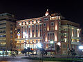
historical Grande Hotel da Póvoa Varzim

Monument to Eça de Queiroz
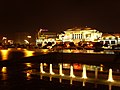
Casino Casino da Povoa

On Praia Verde beach


administration
The circle

Póvoa de Varzim is the seat of a district of the same name ( concelho ) in the Porto district . On June 30, 2011 the district had 63,408 inhabitants on an area of 82.2 km².
The neighboring areas are (starting clockwise in the north): Esposende , Barcelos , Vila Nova de Famalicão , Vila do Conde and the Atlantic Ocean.

With the regional reform in September 2013 , several municipalities were merged to form new municipalities, so that the number of municipalities decreased from twelve to eight.
The following municipalities ( Freguesias ) are in the Póvoa de Varzim district:

| local community | Population (2011) |
Area km² |
Density of population / km² |
LAU code |
|---|---|---|---|---|
| Aver-o-Mar, Amorim e Terroso | 13,987 | 16.64 | 840 | 131313 |
| Aguçadoura e Navais | 5,745 | 7.40 | 776 | 131314 |
| Balasar | 2,543 | 11.61 | 219 | 131305 |
| Estela | 2,307 | 11.54 | 200 | 131307 |
| Laundos | 2,055 | 8.53 | 241 | 131308 |
| Póvoa de Varzim, Beiriz e Argivai | 34,266 | 12.60 | 2,721 | 131315 |
| Rates | 2,505 | 13.90 | 180 | 131311 |
| Póvoa de Varzim district | 63,408 | 82.22 | 771 | 1313 |
Population development
As the following overview shows, the population has increased twentyfold in more than 150 years.
Population in the Póvoa de Varzim district (1801–2011) :
| year | 1801 | 1821 | 1830 | 1849 | 1864 | 1878 | 1890 | 1900 |
|---|---|---|---|---|---|---|---|---|
| Residents | 4,676 | 5,672 | 6.097 | 15,300 | 18,704 | 20,578 | 23,372 | 24,527 |
- Note: The figures before 1849 refer only to the local parish of Póvoa de Varzim.
| year | 1911 | 1920 | 1930 | 1940 | 1950 | 1960 | 1970 | 1981 | 1991 | 2001 | 2011 |
|---|---|---|---|---|---|---|---|---|---|---|---|
| Residents | 25,083 | 25,929 | 28,780 | 31,693 | 37,938 | 40,444 | 42,698 | 54,248 | 54,788 | 63,470 | 63,408 |
Municipal holiday
- June 29th

Town twinning
Povoa de Varzim maintains the following cities a twinning :
-
 Eschborn , Federal Republic of Germany (since 1986)
 -
 Montgeron , France (since 1988)
 -
 Żabbar , Malta (since 2001)
Culture
Póvoa de Varzim is known for the Siglas Poveiras , characters that are traced back to Vikings who settled here because of their resemblance to runes . The municipal Museu de Etnografia , housed in the manor house Solar dos Carneiros , has an exhibition area dedicated to the Siglas.
There are also four prehistoric barrows in the area (Mamoa da Estrada). One is in the small town of Águas Férreas .
Since February 2000, the city of Póvoa de Varzim has organized the Iberian literary meeting Correntes d'Escritas , one of the most important events in the Portuguese publishing and literary scene, and has been awarding the Prémio Literário Casino da Póvoa literary prize, endowed with 20,000 euros, since 2004.

Sports
A large number of football clubs are active in the district. The most important is Varzim SC, founded in 1915 . After he was promoted to the first Portuguese league in the meantime (2000) , he is now in the third division, the Campeonato Nacional de Seniores (as of the 2013/14 season).
The sports club Clube Desportivo da Póvoa , founded in 1943, is particularly known for its basketball and swimming departments.
The half marathon Cego do Maio , which takes place every year in March , is a nationally known running competition. In addition, further running events take place here with the Grande Prémio da Marginal in May and the Grande Prémio de São Pedro at the beginning of June.
Every year in April, the Clássica da Primavera is held a spring cycle race. The city is also a frequent stop on the Tour of Portugal .
traffic
Long-distance transport
With the Linha da Póvoa railway line opened in 1875 , the place had its own direct connection to the country's rail network. In 1995 major parts were closed and reopened in 2002 as part of the light rail network in the greater Porto area. The establishment of a new regional railway line on the disused route sections is under discussion.

Póvoa de Varzim is located on the north-south running A28 motorway and the east-facing A7 motorway that begins here .
The city is integrated into the national long-distance bus network of Rede Expressos .
Póvoa de Varzim maintains the Aeródromo da Póvoa de Varzim airfield (officially Aeródromo S. Miguel de Laundos ), which, with its 270 meter long runway, is used for light private planes, sport aircraft and for tourist flights. The nearest international airport is Porto Airport, 15 km south .
Local transport

Póvoa de Varzim is connected as the end point of the red Line B to Porto's light rail system, the Metro do Porto .
A large number of bus routes are operated under municipal concessions by private bus companies, including the Litoral Norte Transportes Urbanos - Póvoa de Varzim , the Transdev and Arriva .
Numerous cycle paths in the urban area are planned and some have already been opened, especially along the coast.
sons and daughters of the town
|
|
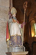
Pedro de Rates

Tomé de Sousa

The Cego do Maio , azulejo picture

Eça de Queirós (1873)

Alexandrina Maria da Costa

Diogo Freitas do Amaral

Luís Carlos Novo Neto


Web links
- Map of the Freguesia Póvoa de Varzim at the Instituto Geográfico do Exército
- Official website of the city administration
- Portal around the city
Individual evidence
- ↑ www.ine.pt - indicator resident population by place of residence and sex; Decennial in the database of the Instituto Nacional de Estatística
- ↑ a b Overview of code assignments from Freguesias on epp.eurostat.ec.europa.eu
- ↑ a b www.ine.pt - indicator resident population by place of residence and sex; Decennial in the database of the Instituto Nacional de Estatística
- ↑ Local history on the website of the city administration (port.), Accessed on April 22, 2017
- ^ Publication of the administrative reorganization in the Diário da República gazette of January 28, 2013, accessed on March 16, 2014

Amarante | Baião | Felgueiras | Gondomar | Lousada | Maia | Marco de Canaveses | Matosinhos | Paços de Ferreira | Paredes | Penafiel | Postage | Póvoa de Varzim | Santo Tirso | Trofa | Valongo | Vila do Conde | Vila Nova de Gaia
| ← Previous location: Vila do Conde |
|
Next town: Viana do Castelo → |