
Maputo Province
| Maputo | |
|---|---|
  |
|
| Basic data | |
| Country | Mozambique |
| Capital | Matola |
| surface | 26,058 km² |
| Residents | 2,507,098 (2017) |
| density | 96 inhabitants per km² |
| ISO 3166-2 | MZ-L |
Coordinates: 25 ° 30 ′ S , 32 ° 20 ′ E
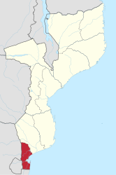
The province of Maputo is located in the very south of Mozambique and is about 26,058 km². The capital of the Maputo province is the city of Matola . The capital of Mozambique, Maputo Cidade , is surrounded by this province, but it is administratively independent.
About 2.5 million people live in the province of Maputo (as of 2017).
Administrative structure
The province of Maputo is divided into eight districts , four of which have the status of Munizip ( município ), so that the population in these can choose their own administration. For the other districts, the leadership is appointed by the governor of the province or the central government.
- Boane (municipality)
- Magude
- Manhiça (municipality)
- Marracuene
- Matutuíne
- Matola (municipality)
- Moamba
- Namaacha (municipality)
Web links
- Portal do Governo da Província de Maputo. on www.pmaputo.gov.mz (Portuguese)
- Ministério da Administração Estatal: Perfis dos Distritos . on www.pmaputo.gov.mz (Portuguese)
Individual evidence
- ^ Mozambique: Provinces, Cities, Urban Localities & Agglomeration - Population Statistics in Maps and Charts. Retrieved November 26, 2017 .
Provinces: Cabo Delgado | Gaza | Inhambane | Manica | Maputo | Maputo (city) | Nampula | Niassa | Sofala | Tete | Zambezia
Districts: see List of Districts of Mozambique
Postos administrativos: see list of Postos administrativos in Mozambique