
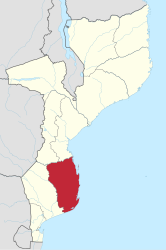
Inhambane Province
| Inhambane | |
|---|---|
  |
|
| Basic data | |
| Country | Mozambique |
| Capital | Inhambane |
| surface | 68,615 km² |
| Residents | 1,496,824 (2017) |
| density | 22 inhabitants per km² |
| ISO 3166-2 | MZ-I |
 |
|
Coordinates: 22 ° 52 ′ S , 34 ° 35 ′ E
The province of Inhambane is located in the southeast of Mozambique on the Mozambique Channel .
geography

Inhambane has an area of 68,615 km². To the north lie the provinces of Sofala and Manica , to the west the province of Gaza .
The capital of the province is also called Inhambane . It has about 63,837 inhabitants (2007). The largest city in the province is Maxixe with 108,824 inhabitants (2007).
Administrative structure
Inhambane Province is divided into eleven districts :
- Funhalouro
- Govuro
- Homoins
- Inharrime
- Inhassoro
- Jangamo
- Mabote
- Massinga
- Morrumbene
- panda
- Vilanculos
- Zavala
population
1,496,824 people live in Inhambane.
economy
Inhambane mainly produces cashew nuts, cotton, rice and sugar cane. In the interior of the country, dried meat is made from beef.
Web links
- Portal do Governo da Província de Inhambane. on www.inhambane.gov.mz (Portuguese)
- Perfis dos Distritos da Província de Inhambane. on www.portaldogoverno.gov.mz (Portuguese)
Provinces: Cabo Delgado | Gaza | Inhambane | Manica | Maputo | Maputo (city) | Nampula | Niassa | Sofala | Tete | Zambezia
Districts: see List of Districts of Mozambique
Postos administrativos: see list of Postos administrativos in Mozambique