
Gaza Province
| Gaza | |
|---|---|
  |
|
| Basic data | |
| Country | Mozambique |
| Capital | Xai-Xai |
| surface | 75,709 km² |
| Residents | 1,446,654 (2017) |
| density | 19 inhabitants per km² |
| ISO 3166-2 | MZ-G |
 |
|
Coordinates: 23 ° 21 ′ S , 32 ° 44 ′ E
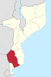
The province of Gaza is located in the southeast of Mozambique .
geography

Gaza has an area of 75,709 km². The province of Manica is to the north , the province of Inhambane to the east and the province of Maputo to the south . In the southeast lies the Mozambique Strait . In the west Gaza borders on neighboring South Africa and in the northwest on Zimbabwe . The capital of the province of Gaza is Xai-Xai with 116,343 inhabitants (2007). Other places are Chókwè , Massingir and Chicualacuala .
The Limpopo and its tributary Changane and Shingwedzi flow through the province . The Sava forms the border river to Manica .
Administrative structure
Gaza is divided into eleven districts :
- Bilene Macia
- Chibuto
- Chicualacuala
- Chigubo
- Chókwè
- Guijá
- Mabalane
- Manjacaze
- Massagesa
- Massingir
- Xai-Xai
history
The Gaza region is mostly inhabited by Tsonga . Gaza was the last Bantu kingdom in the region under the Shangaan chiefs. It was occupied by the Portuguese in 1895, the last chief Gungunhana was deported.
population
Gaza has 1,446,654 inhabitants (2017).
Web links
- Portal do Governo da Província de Gaza. on www.gaza.gov.mz (Portuguese)
- Ministério da Administração Estatal: Perfis dos Distritos da Província de Gaza . on www.portaldogoverno.gov.mz (Portuguese)
Individual evidence
- ^ Mozambique: Provinces, Cities, Urban Localities & Agglomeration - Population Statistics in Maps and Charts. Retrieved November 26, 2017 .
Provinces: Cabo Delgado | Gaza | Inhambane | Manica | Maputo | Maputo (city) | Nampula | Niassa | Sofala | Tete | Zambezia
Districts: see List of Districts of Mozambique
Postos administrativos: see list of Postos administrativos in Mozambique