Castelo de Paiva
| Castelo de Paiva | ||||||
|---|---|---|---|---|---|---|
|
||||||
| Basic data | ||||||
| Region : | Norte | |||||
| Sub-region : | Tâmega e Sousa | |||||
| District : | Aveiro | |||||
| Concelho : | Castelo de Paiva | |||||
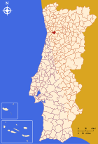
| Coordinates : | 41 ° 3 ′ N , 8 ° 16 ′ W | |||||
| Residents: | 16,733 (as of June 30, 2011) | |||||
| Surface: | 115 km² (as of January 1, 2010) | |||||
| Population density : | 146 inhabitants per km² | |||||
| Castelo de Paiva district | ||||||
|
||||||
| Residents: | 16,733 (as of June 30, 2011) | |||||
| Surface: | 115 km² (as of January 1, 2010) | |||||
| Population density : | 146 inhabitants per km² | |||||
| Number of municipalities : | 6th | |||||
| administration | ||||||
| Administration address: | Câmara Municipal de Castelo de Paiva Largo do Conde - Sobrado 4550-102 Castelo de Paiva |
|||||
| President of the Câmara Municipal: | Dr. Gonçalo Rocha ( PS ) | |||||
| Website: | www.cm-castelo-paiva.pt | |||||
Castelo de Paiva is a vila (small town) and a district ( concelho ) in Portugal with 16,733 inhabitants (as of June 30, 2011).
history
Antas and other finds prove the presence of humans in the water-rich and fertile district since the Paleolithic , Romans , Goths and Arabs also lived here, which excavations such as tombs etc. a. occupy. The place, which was called Payva de Riba Douro and later only Paiva, wasofficially mentioned for the first time in theyear 883 . His first town charter ( Foral ) Paiva received on 1 December 1513 by King Manuel I . Since March 4, 1850, thecirclepreviously onlycalled Paiva has been led under its full current name.
Culture and sights
Various archaeological sites, manor houses , sacred buildings , fountains and historical public buildings are listed in the district, as is the historic center of the district town as a whole.
Despite its numerous architectural monuments, river baths and natural landscapes, tourism is not strongly developed here. There are rural tourism facilities and restaurants. The Marmoiral de Sobrado in the main town of Sobrado is a Romanesque tomb made of granite and part of the Rota do Românico do Vale do Sousa , a route along the region's Romanesque monuments.
On March 4, 2001, the busy old truss bridge Ponte Hintze Ribeiro over the Rio Douro collapsed at the northern tip of the district , killing 59 people. The disaster left the whole country in deep sadness and made headlines across Europe. A memorial for the accident was erected on the newly built bridge.
economy
Coal was mined in the Minas do Pejão from 1886 to 1994, after which the mines were shut down due to a lack of profitability.
Shoe factories, textile industry, wood processing and furniture manufacturing are the main industries in the district.
administration
circle
Castelo de Paiva is the seat of a district of the same name. The neighboring areas are (starting clockwise in the north): Penafiel , Marco de Canaveses , Cinfães , Arouca and Gondomar .
With the regional reform in September 2013 , several municipalities were combined into new municipalities, so that the number of municipalities decreased from nine to six.
The following municipalities ( Freguesias ) are in the Castelo de Paiva district:
| local community | Population (2011) |
Area km² |
Density of population / km² |
LAU code |
|---|---|---|---|---|
| Fornos | 1,439 | 4.11 | 350 | 010602 |
| Raiva, Pedorido e Paraíso | 4,694 | 49.37 | 95 | 010610 |
| real | 1,300 | 33.11 | 39 | 010606 |
| Santa Maria de Sardoura | 2,538 | 10.06 | 252 | 010607 |
| Sao Martinho de Sardoura | 1.931 | 4.31 | 448 | 010608 |
| Sobrado e Bairros | 4,831 | 14.04 | 344 | 010611 |
| Castelo de Paiva district | 16,733 | 115.00 | 146 | 0106 |
Population development
| Population in the district of Castelo de Paiva (1801–2011) | |||||||||
|---|---|---|---|---|---|---|---|---|---|
| 1801 | 1849 | 1900 | 1930 | 1960 | 1981 | 1991 | 2001 | 2011 | |
| 6691 | 7586 | 9728 | 11,450 | 17,756 | 17,026 | 16,515 | 17,338 | 16,733 | |
Municipal holiday
- June 24th
Town twinning
-
 Spain : Fabero , Province of León (since 1995)
 -
 Mozambique : Chibuto , Gaza Province (since 1999)
 -
 Mozambique : Manhiça , Maputo Province (since 1999)
sons and daughters of the town
- António Capelo (born 1956), actor
- João Campos (* 1958), athletics coach
- Cristina Torrão (* 1965), writer
- Marco André Rocha Pereira (* 1987), football player
Web links
Individual evidence
- ↑ a b www.ine.pt - indicator resident population by place of residence and sex; Decennial in the database of the Instituto Nacional de Estatística
- ↑ a b Overview of code assignments from Freguesias on epp.eurostat.ec.europa.eu
- ↑ www.verportugal.net , accessed on January 11, 2013
- ↑ www.cm-castelo-paiva.pt ( Memento of the original from June 18, 2012 in the Internet Archive ) Info: The archive link was inserted automatically and has not yet been checked. Please check the original and archive link according to the instructions and then remove this notice. , accessed January 11, 2013
- ↑ www.monumentos.pt , accessed on January 11, 2013
- ↑ www.cm-castelo-paiva.pt ( Memento of the original from May 19, 2011 in the Internet Archive ) Info: The archive link was inserted automatically and has not yet been checked. Please check the original and archive link according to the instructions and then remove this notice. , accessed January 11, 2013
- ↑ www.monumentos.pt , accessed on January 11, 2013
- ↑ www.verportugal.net , accessed on January 11, 2013
- ^ Publication of the administrative reorganization in the Diário da República gazette of January 28, 2013, accessed on March 16, 2014
- ↑ www.anmp.pt , accessed on January 11, 2013


