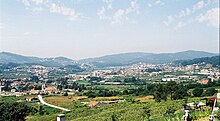
Vale de Cambra
| Vale de Cambra | ||||||
|---|---|---|---|---|---|---|
|
||||||
| Basic data | ||||||
| Region : | Norte | |||||
| Sub-region : | Porto metropolitan area | |||||
| District : | Aveiro | |||||
| Concelho : | Vale de Cambra | |||||
| Coordinates : | 40 ° 51 ′ N , 8 ° 24 ′ W | |||||
| Residents: | 22,864 (as of June 30, 2011) | |||||
| Surface: | 147.34 km² (as of January 1, 2010) | |||||
| Population density : | 155 inhabitants per km² | |||||
| Vale de Cambra county | ||||||
|
||||||
| Residents: | 22,864 (as of June 30, 2011) | |||||
| Surface: | 147.34 km² (as of January 1, 2010) | |||||
| Population density : | 155 inhabitants per km² | |||||
| Number of municipalities : | 7th | |||||
| administration | ||||||
| Administration address: | Câmara Municipal de Vale de Cambra Edifício Municipal Av. Camilo Tavares de Matos, nº 19 3730–901 Vale de Cambra |
|||||
| President of the Câmara Municipal: | José António Bastos da Silva ( PSD ) | |||||
| Website: | www.cm-valedecambra.pt | |||||
Vale de Cambra is a city ( Cidade ) and a district ( concelho ) in the Aveiro district in Portugal with 22,864 inhabitants (as of June 30, 2011).
history
The fertile valley ( Portuguese : Vale ) has been a human settlement area since prehistoric times. The first officially documented mention comes from a deed of donation from King Ordonho II from the year 922. Over the years, the district has had different names, such as Caymbra , Santa Maria de Caymbra , Câmara do Bispo de Coimbra , Cambra and finally Macieira de Cambra . It belonged to the diocese of Mérida , and came to the diocese of Coimbra after 1139 as part of the consolidation of the independent kingdom of Portugal .
In 1514 Macieira de Cambra city rights (received Foral ) by King Manuel I . In 1926, the Macieira de Cambra district became part of the newly created Vale de Cambra district , which had its seat in Gandra in the municipality of Vila Chã . In 1993 the previous Vila (small town) was elevated to a city ( Cidade ), while at the same time the local parishes Macieira de Cambra and São Pedro de Castelões became Vilas .
Culture and sights
Numerous sacred buildings are under monument protection, as are some mansions , stone fountains and former public buildings. The historic center of Vale de Cambra as a whole is also protected.
The Outeiro dos Riscos , a granite monolith with Neolithic and Copper Stone Age engravings, is located at Gatão in the municipality of Cepelos . The Wallburg -Fundstätte Castro do Chão de Carvalho is on 804 meters of altitude, at the site Maciço da Gralheira, in the municipality Arões . It is attributed to the Castro culture.
The Vale de Cambra cultural center, Centro Cultural, hosts a variety of events, such as concerts and dance performances. In a granite stone house built in 1760 in the municipality of Cepelos, there is also the Núcleo Museológico da Casa da Tulha , a branch of the Museu Municipal de Vale de Cambra .
administration
The circle
Vale de Cambra is the seat of a district of the same name. The neighboring areas are (starting clockwise in the north): Arouca , São Pedro do Sul , Oliveira de Frades , Sever do Vouga and Oliveira de Azeméis .

The church of Castelões (in São Pedro de Castelões), decorated with azulejos and surrounded by Portuguese pavement
|
The following communes ( freguesias ) are in the county of Vale de Cambra:
| local community | Population (2011) |
Area km² |
Density of population / km² |
LAU code |
|---|---|---|---|---|
| Arões | 1,459 | 40.33 | 36 | 011901 |
| Cepelos | 1.313 | 18.93 | 69 | 011903 |
| Junqueira | 1,067 | 18.04 | 59 | 011905 |
| Macieira de Cambra | 4,747 | 18.05 | 263 | 011906 |
| Roge | 1,752 | 17.60 | 100 | 011907 |
| Sao Pedro de Casteloes | 7.181 | 21.10 | 340 | 011902 |
| Vila Chã, Codal e Vila Cova de Perrinho | 5,345 | 13.29 | 402 | 011910 |
| Vale de Cambra county | 22,864 | 147.34 | 155 | 0119 |
Population development
| Population in Vale de Cambra County (1801–2011) | |||||||||
|---|---|---|---|---|---|---|---|---|---|
| 1801 | 1849 | 1900 | 1930 | 1960 | 1981 | 1991 | 2001 | 2011 | |
| 9 489 | 10 166 | 12 264 | 15 745 | 20 404 | 24 224 | 24 537 | 24 805 | 22 864 | |
Town twinning
-
 Luxembourg : Mondorf-les-Bains (since 2018)
in preparation:
Web links
Individual evidence
- ↑ a b www.ine.pt - indicator resident population by place of residence and sex; Decennial in the database of the Instituto Nacional de Estatística
- ↑ a b Overview of code assignments from Freguesias on epp.eurostat.ec.europa.eu
- ↑ www.verportugal.net , accessed January 31, 2013
- ↑ www.monumentos.pt , accessed on January 31, 2013
- ↑ www.verportugal.net , accessed January 31, 2013
- ↑ www.centrocultural.cm-valedambra.pt ( Memento of November 16, 2012 in the Internet Archive ), accessed on January 31, 2013
- ↑ www.igogo.pt , accessed January 31, 2013
- ↑ "Instituto Nacional de Estatística"
- ↑ List of town twinning Vale de Cambras at the Association of Portuguese District Governments (ANMP), accessed on February 17, 2019


