Peso da Régua
| Peso da Régua | ||||||
|---|---|---|---|---|---|---|
|
||||||
| Basic data | ||||||
| Region : | Norte | |||||
| Sub-region : | Douro | |||||
| District : | Vila Real | |||||
| Concelho : | Peso da Régua | |||||
| Coordinates : | 41 ° 10 ′ N , 7 ° 47 ′ W | |||||
| Residents: | 17,131 (as of June 30, 2011) | |||||
| Surface: | 94.86 km² (as of January 1, 2010) | |||||
| Population density : | 181 inhabitants per km² | |||||
| Peso da Régua county | ||||||
|
||||||
| Residents: | 17,131 (as of June 30, 2011) | |||||
| Surface: | 94.86 km² (as of January 1, 2010) | |||||
| Population density : | 181 inhabitants per km² | |||||
| Number of municipalities : | 8th | |||||
| administration | ||||||
| Administration address: | Câmara Municipal de Peso da Régua Praça do Município 5054-003 Peso da Régua |
|||||
| President of the Câmara Municipal: | Nuno Manuel Sousa Pinto Carvalho Gonçalves ( PSD ) | |||||
| Website: | www.cm-pesoregua.pt | |||||
Peso da Régua [ ˈpezu ðɐ ˈʁɛɣwɐ ] (also Pêso da Régua , everyday language mostly just Régua ) is a town and a district in the Vila Real district in Portugal with 17,131 inhabitants. Peso da Régua is located on the banks of the Douro , about 100 km east of its mouth in Porto , in Alto Douro , the first protected wine-growing region in the world, and is the center of port wine production .
history
The archaeological excavations of the Estação Arqueológica da Fonte do Milho show a fortified Roman settlement here. Today's district area was repopulated in the course of the conquest by Germanic tribes from the 5th century AD. It gained increasing importance as a trading center due to its small loading port on the Douro, especially for the region's wine. King Sancho I gave the town of Godim town rights in the 12th century, to whose municipal area the small town of Peso also belonged.
After the mercantilist Prime Minister Marquês de Pombal created the world's first protected wine-growing region here in 1756, today's district took off. In 1836 the Peso da Régua district was re-established by splitting off existing districts and its capital was elevated to a vila (small town) in 1837 .
With the arrival of the Linha do Douro railway line in 1878, the town's growth accelerated considerably. In 1985 Peso da Régua became a cidade (city).
Culture and sights
Architectural monuments
A number of chapels and other sacred buildings , bridges, town houses and various former public buildings are under monument protection . The town's train station is also part of it, as is the historic town center as a whole. The city library, the Biblioteca Municipal de Pêso da Régua, is now located in the listed city villa Palacete dos Barretos .
Exhibitions and museums
The Museu do Douro is the museum of the first protected wine-growing region in the world and functions as a documentation center with regional educational offers.
various
- Rota do Vinho do Porto (German: Port Wine Route)
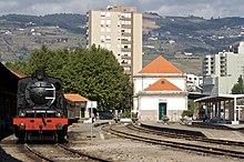
- Estação do caminho de ferro - comboio histórico - with the steam train through the Douro valley , from Regua to Tua and back - like 100 years ago
- various circular routes in the city (port .: percurso urbano ) and the surrounding area ( percurso rural ) have been created
administration
circle
Peso da Régua is the seat of a district of the same name. The neighboring areas are (starting clockwise in the north): Santa Marta de Penaguião , Vila Real , Sabrosa , Armamar , Lamego , Mesão Frio and Baião .
As part of the territorial reform of September 29, 2013 , the number of communes ( freguesias ) in the Peso da Régua county was reduced from 12 to 8:
| local community | Population (2011) |
Area km² |
Density of population / km² |
LAU code |
|---|---|---|---|---|
| Fontelas | 781 | 3.23 | 241 | 170802 |
| Galafura e Covelinhas | 886 | 15.85 | 56 | 170813 |
| Loureiro | 1,154 | 4.86 | 238 | 170805 |
| Moura Morta e Vinhós | 1,024 | 12.80 | 80 | 170814 |
| Peso da Régua e Godim | 9,959 | 10.13 | 983 | 170815 |
| Poiares e Canelas | 1,466 | 27.46 | 53 | 170816 |
| Sediellos | 911 | 12.63 | 72 | 170809 |
| Vilarinho dos Freires | 950 | 7.90 | 120 | 170810 |
| Peso da Régua county | 17.131 | 94.86 | 181 | 1708 |
Population development
| Population in Peso da Régua County (1849–2011) | ||||||||
|---|---|---|---|---|---|---|---|---|
| 1849 | 1900 | 1930 | 1960 | 1981 | 1991 | 2001 | 2011 | |
| 9 202 | 18 401 | 20 612 | 22 634 | 22 472 | 21 567 | 18 832 | 17 131 | |
Town twinning
-
 Marmande (France)
 -
 Tain-l'Hermitage (France)
sons and daughters of the town
- Francisco da Silveira Pinto da Fonseca Teixeira (1763–1821), general in the war against the Napoleonic invasions
- António da Silveira Pinto da Fonseca (1770-1858), officer, absolutist in the Miguelistenkrieg
- Antónia Ferreira (1811-1896), entrepreneur
- João de Lemos (1819–1890), journalist, poet and playwright
- António Bernardo Ferreira (1835–1907), entrepreneur and politician
- Maximiano Lemos (1860–1923), doctor, medical researcher and university lecturer
- Manuel Vieira de Matos (1861–1932), Archbishop of Braga, founder of the Portuguese Catholic Scouts
- Antão Fernandes de Carvalho (1871–1948), politician, Republican Minister of Agriculture
- Tito Augusto de Morais (1880–1963), republican politician, admiral and colonial administrator
- Virgílio Correia (1888–1944), university professor, art historian, archaeologist and journalist
- João de Araújo Correia (1899–1985), doctor and writer
- António Guedes de Amorim (1901–1971), journalist and writer
- Marcos Miranda Guedes (1924–2001), architect in Portuguese East Africa / Mozambique
- Jaime Silva (* 1947), painter
- Duarte Lima (* 1955), lawyer and politician
- Nuno Cardoso (* 1961), politician
Web links
swell
- ↑ a b www.ine.pt - indicator resident population by place of residence and sex; Decennial in the database of the Instituto Nacional de Estatística
- ↑ a b Overview of code assignments from Freguesias on epp.eurostat.ec.europa.eu
- ↑ www.verportugal.net , accessed on February 19, 2013
- ↑ www.monumentos.pt (under Cronologia ), accessed on February 19, 2013
- ↑ www.monumentos.pt , accessed on February 19, 2013
- ↑ ditto
- ↑ Museu do Douro (Portuguese)
- ↑ Rota do Vinho do Porto (English, French, Spanish, Portuguese)
- ↑ http://viajar.clix.pt/noticias.php?id=968&lg=pt


