Armamar
| Armamar | ||||||
|---|---|---|---|---|---|---|
|
||||||
| Basic data | ||||||
| Region : | Norte | |||||
| Sub-region : | Douro | |||||
| District : | Viseu | |||||
| Concelho : | Armamar | |||||
| Coordinates : | 41 ° 6 ′ N , 7 ° 42 ′ W | |||||
| Residents: | 1080 (as of June 30, 2011) | |||||
| Surface: | 9.29 km² (as of January 1, 2010) | |||||
| Population density : | 116 inhabitants per km² | |||||
| Postal code : | 5110-127 | |||||
| Armamar County | ||||||
|
||||||
| Residents: | 6297 (as of June 30, 2011) | |||||
| Surface: | 117.22 km² (as of January 1, 2010) | |||||
| Population density : | 54 inhabitants per km² | |||||
| Number of municipalities : | 14th | |||||
| administration | ||||||
| Administration address: | Câmara Municipal de Armamar Praça da República 5110-127 Armamar |
|||||
| President of the Câmara Municipal: | Hernâni Pinto Fonseca Almeida | |||||
| Website: | www.cm-armamar.pt | |||||
Armamar is a small town ( Vila ) and a district ( concelho ) in Portugal with 1080 inhabitants (as of June 30, 2011). It belongs to the Alto Douro wine-growing region, which has been protected since 1756 , the oldest protected designation of origin , and has been part of the UNESCO World Heritage since 2001 .
history
The place arose in the course of settlement after the conquest of the area by King Alfons III. (Asturias) in 877 . The simple fortification afterwards was created by using an existing castro from pre-Roman times. In the course of the Reconquista , the place was abandoned by its inhabitants, due to the changing conquests by Christians and Moors . It was not until D.Afonso Henriques , the first king of the Kingdom of Portugal , which had been independent since 1139 , that the place was repopulated. 1514 the municipal charter (received Foral ) by King Manuel I .
On September 29, 2013, the parishes of Tões and Coura were incorporated into Armamar.
Culture and sights
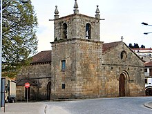
The architectural monuments of Armamar include various mansions , stone fountains, historical public buildings and sacred buildings , including the three-aisled Romanesque - Gothic Igreja Matriz (German: main church) Igreja Paroquial de Armamar (also Igreja de São Miguel ) from the 12th century. The historic town center as a whole is also a listed building.
The excavations of a prehistoric hill fort can be seen in Goujoim .
Hiking trails lead through the district, especially along the vineyards and mansions on the Douro.
economy
The district is predominantly agricultural, in particular wine and olive oil are the most important products, and fruit growing is also important. With an annual harvest of around 50,000 tons, Armamar in Portugal is considered the capital of the mountain apple ( Capital da Maçã de Montanha ). In April, the Festa da Macieira em Flor (German: Apple Tree Blossom Festival) is a nationally known gastronomic and folk festival. Tourism, especially individual tourism, has gained in importance, in particular through facilities of the rural tourism and in connection with the wine region on the Douro .
administration
circle
Armamar is the seat of a district of the same name. The neighboring areas are (starting clockwise in the north): Peso da Régua , Sabrosa , Tabuaço , Moimenta da Beira , Tarouca and Lamego .

Looking beyond the circle, from a Miradouro above Armamars
|
With the regional reform in September 2013, several municipalities were merged into new municipalities, so that the number of municipalities decreased from 19 to 14.
The following municipalities ( freguesias ) are in the Armamar district:
| local community | Population (2011) |
Area km² |
Density of population / km² |
LAU code |
|---|---|---|---|---|
| Aldeias | 337 | 5.19 | 65 | 180101 |
| Aricera e Goujoim | 215 | 10.65 | 20th | 180121 |
| Armamar | 1,464 | 16.75 | 87 | 180120 |
| Cimbres | 308 | 6.07 | 51 | 180104 |
| Folgosa | 428 | 4.80 | 89 | 180106 |
| Fontelo | 641 | 7.52 | 85 | 180107 |
| Queimada | 285 | 4.26 | 67 | 180109 |
| Queimadela | 248 | 2.48 | 100 | 180110 |
| Santa Cruz | 206 | 7.88 | 26th | 180111 |
| Sao Cosmado | 598 | 13.95 | 43 | 180114 |
| São Martinho das Chãs | 549 | 9.67 | 57 | 180115 |
| São Romão e Santiago | 306 | 6.93 | 44 | 180122 |
| Vacalar | 205 | 6.04 | 34 | 180118 |
| Vila Seca e Santo Adrião | 507 | 15.03 | 34 | 180123 |
| Armamar County | 6,297 | 117.22 | 54 | 1801 |
Population development
| Population in the Armamar district (1801–2011) | ||||||||||
|---|---|---|---|---|---|---|---|---|---|---|
| 1801 | 1849 | 1900 | 1930 | 1960 | 1981 | 1991 | 2001 | 2011 | ||
| 3,641 | 4,882 | 12.092 | 11,330 | 12,159 | 9,426 | 8,677 | 7,492 | 9,297 | ||
Municipal holiday
- June 24th
Town twinning
Web links
- Map of the Freguesia Armamar at the Instituto Geográfico do Exército
- Official website
Individual evidence
- ↑ www.ine.pt - indicator resident population by place of residence and sex; Decennial in the database of the Instituto Nacional de Estatística
- ↑ a b Overview of code assignments from Freguesias on epp.eurostat.ec.europa.eu
- ↑ www.ine.pt - indicator resident population by place of residence and sex; Decennial in the database of the Instituto Nacional de Estatística
- ↑ www.verportugal.net , accessed on February 22, 2013
- ^ Publication of the administrative reorganization in the Diário da República gazette of January 28, 2013, accessed on October 1, 2014
- ↑ www.monumentos.pt , accessed on February 22, 2013
- ↑ ditto
- ↑ www.dourovalley.eu , accessed on February 23, 2013
- ^ Publication of the administrative reorganization in the Diário da República gazette of January 28, 2013, accessed on March 16, 2014
- ↑ www.anmp.pt , accessed on February 22, 2013


