Loures
| Loures | ||||||
|---|---|---|---|---|---|---|
|
||||||
| Basic data | ||||||
| Region : | Lisboa | |||||
| Sub-region : | Lisbon metropolitan area | |||||
| District : | Lisbon | |||||
| Concelho : | Loures | |||||
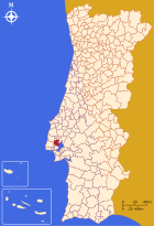
| Coordinates : | 38 ° 50 ′ N , 9 ° 10 ′ W | |||||
| Residents: | 26,769 (as of June 30, 2011) | |||||
| Surface: | 32.82 km² (as of January 1, 2010) | |||||
| Population density : | 816 inhabitants per km² | |||||
| Postal code : | 2670 | |||||
| politics | ||||||
| Mayor : | João Luís Costa Nunes ( PS ) | |||||
| Address of the municipal administration: | Junta de Freguesia de Loures Rua Manuel Francisco Soromenho, n.º 50 2670-452 Loures |
|||||
| Website: | www.jf-loures.pt | |||||
| Loures county | ||||||
|
||||||
| Residents: | 199,494 (as of June 30, 2011) | |||||
| Surface: | 167.25 km² (as of January 1, 2010) | |||||
| Population density : | 1193 inhabitants per km² | |||||
| Number of municipalities : | 10 | |||||
| administration | ||||||
| Administration address: | Câmara Municipal de Loures Praça da Liberdade, 4 2674-501 Loures |
|||||
| President of the Câmara Municipal: | Carlos Alberto Dias Teixeira ( PS ) | |||||
| Website: | www.cm-loures.pt | |||||
Loures is a city in Portugal . The Loures district borders on the capital Lisbon . The republic was proclaimed here on October 4, 1910, one day before the official proclamation. The carnival, which has been celebrated here since 1934, is known nationwide.
history
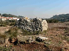
Finds, especially Antas , prove a prehistoric settlement. During the time of the Arab al-Andalus , the Moors maintained a settlement here until they were expelled by the Reconquista in the 12th century. The area has belonged to Lisbon since then and was an air resort for noble families, for example during the plague epidemics. The independent district of Loures was set up on July 26, 1886 , by merging municipalities that were spun off from the now dissolved districts of Olivais and Belém. On October 4, 1910 was the Republican town hall of Loures flag of Portugal and hoisted (the Revolutionary port. : Junta Revolucionaria ), the First Portuguese Republic was proclaimed, one day before the official proclamation. The previous small town ( Vila ) Loures was elevated to a town ( Cidade ) in 1990 .
administration
Loures county

The town hall ( Câmara Municipal ) of Loures
|
Loures is the administrative seat of a district of the same name ( concelho ). On June 30, 2011 the district had 199,494 inhabitants on an area of 167.3 km².
The neighboring districts are (starting clockwise from the north): Arruda dos Vinhos , Vila Franca de Xira , the Tagus Delta , Lisbon , Odivelas , Sintra and Mafra .
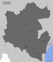
With the regional reform in September 2013, several municipalities were combined into new municipalities, so that the number of municipalities decreased from 18 to ten.
The following municipalities ( Freguesias ) are in the county of Loures:
| local community | Population (2011) |
Area km² |
Density of population / km² |
LAU code |
|---|---|---|---|---|
| Bucelas | 4,663 | 33.97 | 137 | 110702 |
| Camarate, Unhos e Apelação | 34,943 | 11.57 | 3,021 | 110731 |
| Fanhões | 2,801 | 11.63 | 241 | 110705 |
| Loures | 26,769 | 32.81 | 816 | 110707 |
| Lousa | 3,169 | 16.52 | 192 | 110708 |
| Moscavide e Portela | 21,891 | 1.66 | 13,217 | 110726 |
| Sacavém e Prior Velho | 24,822 | 3.89 | 6,388 | 110727 |
| Santa Iria de Azoia, São João da Talha e Bobadela | 44,331 | 17.59 | 2,520 | 110728 |
| Santo Antão e São Julião do Tojal | 8,053 | 28.41 | 283 | 110729 |
| Santo António dos Cavaleiros e Frielas | 28.052 | 9.20 | 3,050 | 110730 |
| Loures county | 199.494 | 167.25 | 1,193 | 1107 |
Population development
In particular due to the influx in the course of industrial development, reinforced by the establishment of EFTA in 1960, the population in the district grew significantly.
| Population in Loures County (1890–2011) | ||||||||||||||
|---|---|---|---|---|---|---|---|---|---|---|---|---|---|---|
| 1890 | 1900 | 1910 | 1920 | 1930 | 1940 | 1950 | 1960 | 1970 | 1981 | 1991 | 2001 | 2011 | ||
| 18,219 | 22,325 | 26,274 | 26,684 | 29,014 | 35,060 | 50,440 | 102.184 | 166,550 | 276,467 | 322.158 | 199.059 | 205,577 | ||
Municipal holiday
- July 26th
Town twinning
-
 Cape Verde : Maio (since 1993)
 -
 Portugal : Armamar (since 1993)
 -
 Mozambique : Matola (since 1996)
 -
 India : Diu (since 1998)
Loures is also in a city friendship with Grevesmühlen in Mecklenburg-Western Pomerania .
sons and daughters of the town
- Baltasar Barreira (1538–1612), Jesuit missionary in Africa, particularly in Angola
- Félix Avelar Brotero (1744–1828), botanist and university professor
- Luís António Furtado de Castro do Rio de Mendonça e Faro (1754–1830), colonial governor in Minas Gerais , member of the Portuguese commission of General Junot in 1808 to Napoleon during the French invasions of Portugal
- Marcos Romão dos Reis Júnior (1917–2000), musician and composer, director of the Portuguese naval orchestra
- Alfredo Dinis (1917–1945), communist resistance fighter against the Estado Novo regime
- Fernando Real (1923–2006), politician, environment minister in the Cavaco Silva II cabinet
- José da Cruz (1923–2006), hairdresser and magician, father of Irene Cruz and Henriqueta Maya
- Eduardo Gageiro (* 1935), photographer
- Irene Cruz (* 1943), actress, sister of Henriqueta Maya
- Henriqueta Maya (* 1945), actress, sister of Irene Cruz
- Jerónimo de Sousa (* 1947), politician, general secretary of the Portuguese Communist Party
- Júlio Pereira (* 1953), musician and composer
- Eduardo Luís Marques Kruss Gomes (* 1955), former soccer player and soccer coach
- Rosa Villa (born 1963), actress
- Nuno Távora (* 1976), actor
- Cláudia Vieira (* 1979), model and actress
- Rita Redshoes (* 1981), musician
- António Alberto Bastos Pimparel "Beto" (* 1982), football goalkeeper
- Hugo Miguel Carolo da Silva (* 1985), football player
- Tiago Alexandre Carvalho Gonçalves (* 1989), football player
- Tiago Manuel Dias Correia "Bébé" (* 1990), football player
Web links
- Map of the Freguesia Loures at the Instituto Geográfico do Exército
- Official website
Individual evidence
- ↑ www.ine.pt - indicator resident population by place of residence and sex; Decennial in the database of the Instituto Nacional de Estatística
- ↑ a b Overview of code assignments from Freguesias on epp.eurostat.ec.europa.eu
- ^ Website of the Município ( Memento of the original from March 29, 2010 in the Internet Archive ) Info: The archive link was automatically inserted and not yet checked. Please check the original and archive link according to the instructions and then remove this notice. , Portuguese, accessed April 17, 2010
- ↑ a b www.ine.pt - indicator resident population by place of residence and sex; Decennial in the database of the Instituto Nacional de Estatística
- ↑ www.verportugal.net , accessed October 11, 2013
- ^ Publication of the administrative reorganization in the Diário da República gazette of January 28, 2013, accessed on March 16, 2014
- ↑ www.anmp.pt , accessed on October 26, 2013
- ↑ Entry on the partner and friend cities on the homepage of the city of Grevesmühlen.Retrieved on April 3, 2019, 12:51


