Alenquer (Portugal)
| Alenquer | ||||||
|---|---|---|---|---|---|---|
|
||||||
| Basic data | ||||||
| Region : | Centro | |||||
| Sub-region : | Oeste | |||||
| District : | Lisbon | |||||
| Concelho : | Alenquer | |||||
| Coordinates : | 39 ° 3 ' N , 9 ° 1' W | |||||
| Residents: | 43,257 (as of June 30, 2011) | |||||
| Surface: | 304.22 km² (as of January 1, 2010) | |||||
| Population density : | 142 inhabitants per km² | |||||
| Postal code : | 2580 | |||||
| Alenquer district | ||||||
|
||||||
| Residents: | 43,257 (as of June 30, 2011) | |||||
| Surface: | 304.22 km² (as of January 1, 2010) | |||||
| Population density : | 142 inhabitants per km² | |||||
| Number of municipalities : | 11 | |||||
| administration | ||||||
| Administration address: | Câmara Municipal de Alenquer Praça Luis de Camoes 2580-318 Alenquer |
|||||
| President of the Câmara Municipal: | Jorge Manuel da Cunha Mendes Riso | |||||
| Website: | www.cm-alenquer.pt | |||||
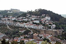
Alenquer is a small town ( Vila ) in the Oeste sub-region in Portugal with 43,257 inhabitants (as of June 30, 2011).
history
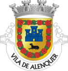
There was already a settlement in the nearby Pedra do Ouro in the Copper Age . The city of Alenquer, founded by Alans in the first half of the 5th century , still has an Alanian war dog, an Alaunt , in its coat of arms. Alenquer received royal town charter in 1212 .
Alenquer was home to a significant Jewish community. The place is now part of the Rede de Judiarias , the Route of Historic Jewish Places in Portugal.
administration
The circle
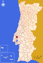
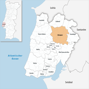
Alenquer is the administrative seat of a district of the same name ( concelho ) in the Lisbon district . The neighboring districts are (starting clockwise in the north): Cadaval , Azambuja , Vila Franca de Xira , Arruda dos Vinhos , Sobral de Monte Agraço and Torres Vedras .
With the regional reform in September 2013, several municipalities were merged into new municipalities, so that the number of municipalities decreased from 16 to eleven.
The following eleven municipalities ( Freguesias ) are in the Alenquer district:
| local community | Population (2011) |
Area km² |
Density of population / km² |
LAU code |
|---|---|---|---|---|
| Abrigada e Cabanas de Torres | 4,309 | 46.15 | 93 | 110117 |
| Aldeia Galega da Merceana e Aldeia Gavinha | 3,221 | 27.96 | 115 | 110118 |
| Alenquer (Santo Estêvão e Triana) | 10,821 | 50.08 | 216 | 110119 |
| Carnota | 1,671 | 18.09 | 92 | 110106 |
| Carregado e Cadafais | 13,441 | 24.52 | 548 | 110120 |
| Meca | 1,719 | 14.12 | 122 | 110107 |
| Olhalvo | 1,907 | 8.30 | 230 | 110108 |
| Ota | 1,289 | 46.32 | 28 | 110109 |
| Ribafria e Pereiro de Palhacana | 1,547 | 18.34 | 84 | 110121 |
| Ventosa | 2,170 | 22.21 | 98 | 110113 |
| Vila Verde dos Francos | 1,162 | 28.13 | 41 | 110114 |
| Alenquer district | 43,257 | 304.22 | 142 | 1101 |
Population development
| Population in the Alenquer district (1801–2011) | |||||||||
|---|---|---|---|---|---|---|---|---|---|
| 1801 | 1849 | 1900 | 1930 | 1960 | 1981 | 1991 | 2001 | 2011 | |
| 10,569 | 10,005 | 24,774 | 30,015 | 34,998 | 34,575 | 34,098 | 39,180 | 43,267 | |
Buildings
- Castelo de Alenquer (Triana)
- Castelo de Vila Verde dos Francos (Vila Verde dos Francos)
sons and daughters of the town
- Damião de Góis (1502–1574), diplomat and historian
- Dantas Pereira (1772–1836), rear admiral and miguelist
- Bento Pereira do Carmo (1776–1845), large landowner, lawyer and liberal politician
- José António Soares Leal (1810–1873), liberal military man and ambassador of Portugal in Vienna
- Luz de Almeida (1867–1939), librarian, politician and Freemason
- Palmira Bastos (1875–1967), actress
- Hipólito Cabaço (1885–1970), archaeologist
- João Manuel Ferreira Simões (* 1932), journalist
- Pedro Pinheiro (1939–2008), comedian and actor
- Alexandre Manuel Costa Ruas (* 1956), racing cyclist
- Eduardo Henriques (* 1968), Olympic athlete and trainer
- Pedro Lamy (* 1972), racing car driver
- Alda Gomes (* 1979), actress
- Diana Lucas (* 1986), singer
Web links
Individual evidence
- ↑ a b www.ine.pt - indicator resident population by place of residence and sex; Decennial in the database of the Instituto Nacional de Estatística
- ↑ a b Overview of code assignments from Freguesias on epp.eurostat.ec.europa.eu
- ^ Publication of the administrative reorganization in the Diário da República gazette of January 28, 2013, accessed on March 16, 2014
