Vila Franca de Xira
| Vila Franca de Xira | ||||||
|---|---|---|---|---|---|---|
|
||||||
| Basic data | ||||||
| Region : | Lisboa | |||||
| Sub-region : | Lisbon metropolitan area | |||||
| District : | Lisbon | |||||
| Concelho : | Vila Franca de Xira | |||||
| Coordinates : | 38 ° 57 ′ N , 8 ° 59 ′ W | |||||
| Residents: | 18,197 (as of June 30, 2011) | |||||
| Surface: | 212.87 km² (as of January 1, 2010) | |||||
| Population density : | 85 inhabitants per km² | |||||
| politics | ||||||
| Address of the municipal administration: | Junta de Freguesia de Vila Franca de Xira Rua Dr. Vasco Moniz, nº 27/29 2600-273 Vila Franca de Xira |
|||||
| Website: | www.jf-xfxira.pt | |||||
| Vila Franca de Xira district | ||||||
|
||||||
| Residents: | 136,886 (as of June 30, 2011) | |||||
| Surface: | 318.2 km² (as of January 1, 2010) | |||||
| Population density : | 430 inhabitants per km² | |||||
| Number of municipalities : | 6th | |||||
| administration | ||||||
| Administration address: | Câmara Municipal de Vila Franca de Xira Avenida Combatentes da Grande Guerra, nº 80 2600-131 Vila Franca de Xira |
|||||
| President of the Câmara Municipal: | Maria da Luz Rosinha ( PS ) | |||||
| Website: | www2.cm-vfxira.pt | |||||
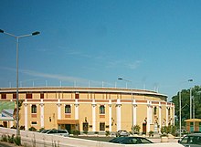
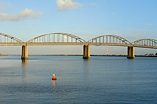
Vila Franca de Xira is a Portuguese city in the Lisbon district and is located about 35 km northeast of Lisbon on the west bank of the Tagus . Vila Franca de Xira is known for its bullfighting tradition.
history
Finds, including ceramics and tombs, show settlement since the late Neolithic . The present-day place was probably created in the course of the repopulation during the Reconquista , possibly by French supporters of the first Portuguese king, D.Afonso Henriques . First city rights POVOS received at Vila Franca de Xira in 1195 by King D.Sancho I . In 1206 Alhandra received city rights from the Bishop of Lisbon, D.Soeiro. In 1212, Cira received city rights, which had been run as Vila Franca de Xira since the 14th century. King D. Manuel I renewed the city rights of Vila Franca de Xira, Povos and Castanheira in 1510.
In 1810 General Wellington had fortifications built here as part of his line of defense against the Napoleonic invasions from Torres Vedras . After the Liberal Revolution of 1822 , Vila Franca became the starting point for a coup d'état led by the absolutist heir to the throne, D.Miguel, against the new liberal constitution of his brother D.Pedro . The place was then renamed Vila Franca da Restauração (German: Vila Franca of the Restoration), until the defeat of the survey in the following year and the renaming of the place. In 1855, the Alverca districts, which had existed since the Middle Ages, were Castanheira , which was dissolved in 1837 , Alhandra , Povos , which was dissolved in 1836 (today a village in the municipality of Vila Franca de Xira), and Vila Franca de Xira to form today's district. With the annexation of the municipalities of Vialonga (with the dissolution of the Olivais district in 1886 ) and Santa Iria de Azóia (1926), the current expansion of the Vila Franca de Xira district was established.
After the country's first industrial tannery opened here in 1729 , the opening of the Lisbon-Carregado railway in 1856 began the further industrial development of Vila Francas. In 1892 two textile factories opened in Alhandras, and in 1894 António Teófilo de Araújo Rato founded a cement factory here, which became today's Cimpor . With the increasing industrialization of the district, especially since the 1950s, its population also grew. On June 28, 1984, the former Vila (small town) Vila Franca de Xira was elevated to a Cidade (city), but kept its name.
administration
The circle
Vila Franca de Xira is the administrative seat of a district of the same name ( concelho ) in the Lisbon district . On June 30, 2011 the district had 136,886 inhabitants on an area of 318.2 km².
The neighboring regions are (starting clockwise in the north): Alenquer , Azambuja , Benavente , Loures and Arruda dos Vinhos .
The following municipalities ( Freguesias ) are in the Vila Franca de Xira district:
With the regional reform in September 2013 , several municipalities were merged into new municipalities, so that the number of municipalities decreased from eleven to six.
| local community | Population (2011) |
Area km² |
Density of population / km² |
LAU code |
|---|---|---|---|---|
| Alhandra, São João dos Montes e Calhandriz | 12,866 | 27.54 | 467 | 111412 |
| Alverca do Ribatejo e Sobralinho | 36,120 | 23.92 | 1,510 | 111413 |
| Castanheira do Ribatejo e Cachoeiras | 8,266 | 26.78 | 309 | 111414 |
| Póvoa de Santa Iria e Forte da Casa | 40,404 | 9.16 | 4,410 | 111415 |
| Vialonga | 21,033 | 17.93 | 1,173 | 111408 |
| Vila Franca de Xira | 18,197 | 212.87 | 85 | 111409 |
| Vila Franca de Xira district | 136,886 | 318.20 | 430 | 1114 |
Population development
| year | 1801 | 1849 | 1900 | 1930 | 1960 | 1981 | 1991 | 2001 | 2004 | 2008 | 2011 |
|---|---|---|---|---|---|---|---|---|---|---|---|
| Residents | 3,839 | 5,202 | 15,766 | 24.053 | 40,594 | 88.193 | 103,571 | 122.908 | 133,224 | 142.163 | 136,510 |
Municipal holiday
Town twinning
-
 France : Villejuif (since 1981)
 -
 Cape Verde : Santa Catarina , Santiago Island (since 1987)
economy
A large number of industrial and trading companies are located in the Vila Franca district, including the main plant of the world's tenth largest cement manufacturer Cimpor . The beverage producer Central Cervejas e Bedidas , which, among other things, is the market leader with the Sagres beer brand , has its headquarters in the municipality of Vialonga.
traffic
There is a rail link with the Linha do Norte , which is the most important route in the country with the connection between Lisbon and Porto. Vila Franca de Xira is also integrated into the national bus network of Rede Expressos .
The place is located directly on the A1 motorway , which leads from Lisbon to Porto. The cities of Benavente and Alverca do Ribatejo can be reached via the nearby A10 motorway in an east-west direction.
sons and daughters of the town
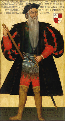
- Afonso de Albuquerque (1453–1515), navigator, second governor of Portuguese India
- Brás de Albuquerque (1501–1581), entrepreneur and writer
- José da Costa e Silva (1747–1819), architect
- José Tomás de Sousa Martins (1843–1897), popular doctor and university professor
- Júlio Zeferino Schultz Xavier (1850–1939), naval officer and engineer
- Miguel Esguelha (1878–1938), politician
- Reynaldo dos Santos (1880–1970), surgeon, urologist and developer of venography
- Alves Redol (1911-1969), writer
- António Dias Lourenço (1915–2010), member of the Portuguese Communist Party , editor-in-chief of Avante!
- Igrejas Caeiro (1917–2012), actor and journalist, socialist politician
- Alberto Franco Nogueira (1918–1993), politician and diplomat, Foreign Minister of the Estado Novo regime
- Baptista Pereira (1921–1984), swimmer
- Octávio Pato (1925–1999), politician, Communist presidential candidate 1976
- António José Forte (1931–1988), writer and journalist, surrealist poet
- Álvaro Guerra (1936–2002), writer, politician and diplomat
- Rogério Ceitil (* 1937), director
- José Carlos da Silva José (* 1941), national soccer player
- Maria da Luz Rosinha (* 1948), politician
- António Moreira Antunes (* 1953), caricaturist
- António Ribeiro Telles (* 1963), bullfighter (rider)
- Maria João Luís (* 1964), actress
- Fernanda Câncio (* 1964), journalist
- Ana Cristina Silva (* 1964), university lecturer and writer
- Paulo Brissos (* 1970), musician
- Rui Vitória (* 1970), football player and coach
- Rogério Matias (* 1974), football player
- Bruno Alexandre Santos Patacas (* 1977), football player
- Helena Costa (* 1978), soccer player and coach
- Albano Jerónimo (* 1979), actor
- Luís Miguel Assunção Joaquim (* 1979), football player
- Ultra Psycho (João Filipe Pedro Ruivo, * 1980), wrestler
- Miguel Domingues (* 1982), television presenter
- Eurípedes Amoreirinha (* 1984), football player
- Tiago Filipe Figueiras Gomes (* 1985), football player
- Vera Barbosa (* 1989), track and field athlete
- Ivan Cavaleiro (born 1993), football player
- Rafael Ferreira Silva (* 1993), football player
Web links
- Map of the Freguesia Vila Franca de Xira at the Instituto Geográfico do Exército
- Official website ( Memento of October 10, 2014 in the Internet Archive )
Individual evidence
- ↑ www.ine.pt - indicator resident population by place of residence and sex; Decennial in the database of the Instituto Nacional de Estatística
- ↑ a b Overview of code assignments from Freguesias on epp.eurostat.ec.europa.eu
- ↑ a b www.ine.pt - indicator resident population by place of residence and sex; Decennial in the database of the Instituto Nacional de Estatística
- ↑ www.verportugal.net , accessed October 11, 2013
- ^ Publication of the administrative reorganization in the Diário da República gazette of January 28, 2013, accessed on March 16, 2014
- ↑ www.anmp.pt , accessed on October 26, 2013
- ↑ Contact address of Central Cervejas e Bedidas. (No longer available online.) Centralcervejas.pt, formerly in the original ; accessed on July 2, 2010 (English, also in Portuguese). ( Page no longer available , search in web archives ) Info: The link was automatically marked as defective. Please check the link according to the instructions and then remove this notice.
| ← Previous location: Lisbon |
|
Next town: Azambuja → |


