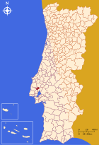
Arruda dos Vinhos
| Arruda dos Vinhos | ||||||
|---|---|---|---|---|---|---|
|
||||||
| Basic data | ||||||
| Region : | Centro | |||||
| Sub-region : | Oeste | |||||
| District : | Lisbon | |||||
| Concelho : | Arruda dos Vinhos | |||||
| Coordinates : | 38 ° 59 ′ N , 9 ° 5 ′ W | |||||
| Residents: | 8656 (as of June 30, 2011) | |||||
| Surface: | 34.38 km² (as of January 1, 2010) | |||||
| Population density : | 252 inhabitants per km² | |||||
| Postal code : | 2630-112 | |||||
| politics | ||||||
| Mayor : | Márcio Bruno Viduedo Dionisio | |||||
| Address of the municipal administration: | Junta de Freguesia de Arruda dos Vinhos Largo António Luís Macedo, 2 2630-112 Arruda dos Vinhos |
|||||
| Website: | www.freguesia-arruda.pt | |||||
| Arruda dos Vinhos district | ||||||
|
||||||
| Residents: | 13,391 (as of June 30, 2011) | |||||
| Surface: | 77.96 km² (as of January 1, 2010) | |||||
| Population density : | 172 inhabitants per km² | |||||
| Number of municipalities : | 4th | |||||
| administration | ||||||
| Administration address: | Câmara Municipal de Arruda dos Vinhos Largo Miguel Bombarda 2630-112 Arruda dos Vinhos |
|||||
| President of the Câmara Municipal: | André Rijo ( PS ) | |||||
| Website: | www.cm-arruda.pt | |||||
Arruda dos Vinhos is a small town ( vila ) in Portugal .
history
Antas and other finds prove a prehistoric settlement. From Roman times comes u. a. the Forno da Pipa stove and a stone on a Roman road . The place name Arruda is connected to the rhombus type (Latin Ruta) of the wine rue, which occurs in large numbers here , and developed from the Latin Ruta and Arabic al-Ruta via Ar-Ruta to the present-day form.
The current place was probably created in the course of the resettlement policy during the Reconquista . Arruda was officially mentioned for the first time in his town charter, which was issued by Portugal's first king, D.Afonso Henriques, in 1160. In 1172 he handed the area over to the Santiagoorden , which promoted local agriculture and, in particular, viticulture. The place name Arruda received the addition dos Vinhos ( Portuguese for: the wines) over time.
King D. Manuel I renewed the town charter in 1517 as part of his administrative reforms. He also stayed in Arruda for a time when the plague was rampant in Lisbon. In gratitude, he had the church Igreja da Nossa Senhora da Salvação built here (English: Church of Our Lady of Salvation).
In and around Arruda were fortifications of the lines of Torres Vedras , a line of defense against the Napoleonic invasions established by General Wellington in 1810 .
administration
The circle
Arruda dos Vinhos is the seat of a circle of the same name ( concelho ) in the Lisbon district . On June 30, 2011 the district had 13,391 inhabitants on an area of 78 km².
The neighboring districts are (starting clockwise in the north): Alenquer , Vila Franca de Xira , Loures , Mafra , and Sobral de Monte Agraço .
The following municipalities ( Freguesias ) are in the Arruda dos Vinhos district:
| local community | Population (2011) |
Area km² |
Density of population / km² |
LAU code |
|---|---|---|---|---|
| Arruda dos Vinhos | 8,656 | 34.38 | 252 | 110202 |
| Arranhó | 2,531 | 21.47 | 118 | 110201 |
| Cardosas | 836 | 6.01 | 139 | 110203 |
| Santiago dos Velhos | 1,368 | 16.09 | 85 | 110204 |
| Arruda dos Vinhos district | 13,391 | 77.96 | 172 | 1102 |
Population development
| Population in the Arruda dos Vinhos district (1801–2011) | |||||||||
|---|---|---|---|---|---|---|---|---|---|
| 1801 | 1849 | 1900 | 1930 | 1960 | 1981 | 1991 | 2001 | 2011 | |
| 2,789 | 4,339 | 5 547 | 7 670 | 8 021 | 8,875 | 9 364 | 10 350 | 13 408 | |
Municipal holiday
Town twinning
-
 Spain : Moixent , Valencia Province (since 1999)
sons and daughters of the town
- João Lobo Brandão de Almeida (* 1759), officer in the Portuguese-British defense forces against the Napoleonic invasions at the beginning of the 19th century.
- Irene Lisboa (1892–1958), writer and teacher
Web links
- Map of the Freguesia Arruda dos Vinhos at the Instituto Geográfico do Exército
- Official website of the city administration
- Photos from ARRUDA DOS VINHOS on Flickr
Individual evidence
- ↑ www.ine.pt - indicator resident population by place of residence and sex; Decennial in the database of the Instituto Nacional de Estatística
- ↑ a b Overview of code assignments from Freguesias on epp.eurostat.ec.europa.eu
- ↑ a b www.ine.pt - indicator resident population by place of residence and sex; Decennial in the database of the Instituto Nacional de Estatística
- ^ João Fonseca: Dicionário do Nome das Terras. 2nd edition, Casa das Letras, Cruz Quebrada 2007, p. 39f ISBN 978-972-46-1730-5
- ↑ www.verportugal.net , accessed October 11, 2013
- ↑ www.anmp.pt , accessed on October 26, 2013


