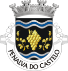
Penalva do Castelo
| Penalva do Castelo | ||||||
|---|---|---|---|---|---|---|
|
||||||
| Basic data | ||||||
| Region : | Centro | |||||
| Sub-region : | Dão-Lafoes | |||||
| District : | Viseu | |||||
| Concelho : | Penalva do Castelo | |||||
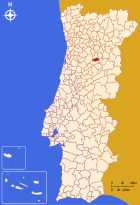
| Coordinates : | 40 ° 40 ′ N , 7 ° 42 ′ W | |||||
| Residents: | 7956 (as of June 30, 2011) | |||||
| Surface: | 134.33 km² (as of January 1, 2010) | |||||
| Population density : | 59 inhabitants per km² | |||||
| Penalva do Castelo county | ||||||
|
||||||
| Residents: | 7956 (as of June 30, 2011) | |||||
| Surface: | 134.33 km² (as of January 1, 2010) | |||||
| Population density : | 59 inhabitants per km² | |||||
| Number of municipalities : | 11 | |||||
| administration | ||||||
| Administration address: | Câmara Municipal de Penalva do Castelo Avenida Castendo 3550-185 Penalva do Castelo |
|||||
| President of the Câmara Municipal: | Dr. Leonidio Monteiro | |||||
| Website: | www.cm-penalvadocastelo.pt | |||||
Penalva do Castelo is a small town ( Vila ) and a district ( Concelho ) in Portugal with 7956 inhabitants (as of June 30, 2011).
history
Finds prove a prehistoric settlement. Celtic Lusitanians lived here. They were made by the Romans in the 2nd century BC. Subjected to BC. From 711 the Moors also conquered this area in the course of their conquest.
In the 12th century, D.Teresa and her son, who later became the first king of Portugal, D.Afonso Henriques , had their first monastery built here. After the independence of Portugal Afonso Henriques gave the place city rights for the first time in 1102 .
King Manuel I renewed the town charter in 1514 . After the place was previously called Castanedo, it was renamed Penalva do Castelo in 1957 .
administration
circle
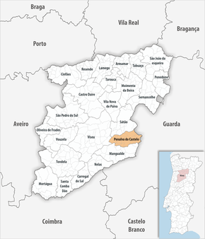
 Penalva do Castelo is the administrative seat of a district of the same name. The neighboring districts are (starting clockwise in the north): Sátão , Aguiar da Beira , Fornos de Algodres , Mangualde and Viseu .
With the regional reform in September 2013 , several municipalities were merged into new municipalities, so that the number of municipalities decreased from 13 to 11.
The following municipalities ( freguesias ) are in the Penalva do Castelo county:
| local community | Population (2011) |
Area km² |
Density of population / km² |
LAU code |
|---|---|---|---|---|
| Antas e Matela | 473 | 18.27 | 26th | 181114 |
| Castelo de Penalva | 914 | 27.16 | 34 | 181102 |
| Esmolfe | 417 | 10.87 | 38 | 181103 |
| Germil | 427 | 5.46 | 78 | 181104 |
| Ínsua | 2,045 | 9.44 | 217 | 181105 |
| Lusinde | 189 | 2.81 | 67 | 181106 |
| Pindo | 1.916 | 16.76 | 114 | 181109 |
| real | 263 | 4.69 | 56 | 181110 |
| Sezures | 726 | 21.04 | 35 | 181111 |
| Trancozelos | 269 | 5.12 | 52 | 181112 |
| Vila Cova do Covelo e Mareco | 317 | 12.71 | 25th | 181115 |
| Penalva do Castelo county | 7,956 | 134.33 | 59 | 1811 |
Population development
| Population of Penalva do Castelo (1981-2011) | ||||||||||
|---|---|---|---|---|---|---|---|---|---|---|
| 1981 | 1991 | 2001 | 2011 | |||||||
| 10.142 | 8,980 | 9,018 | 8.001 | |||||||
Municipal holiday
- August 25
Town twinning
-
 United States : Cumberland (since 1995)
Web links
Individual evidence
- ↑ a b www.ine.pt - indicator resident population by place of residence and sex; Decennial in the database of the Instituto Nacional de Estatística
- ↑ a b Overview of code assignments from Freguesias on epp.eurostat.ec.europa.eu
- ↑ www.verportugal.net , accessed on August 20, 2013
- ↑ www.monumentos.pt (under Cronologia ), accessed on August 20, 2013
- ^ Publication of the administrative reorganization in the Diário da República gazette of January 28, 2013, accessed on March 16, 2014
- ↑ www.anmp.pt , accessed on August 20, 2013


