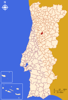
Carregal do Sal
| Carregal do Sal | ||||||
|---|---|---|---|---|---|---|
|
||||||
| Basic data | ||||||
| Region : | Centro | |||||
| Sub-region : | Dão-Lafoes | |||||
| District : | Viseu | |||||
| Concelho : | Carregal do Sal | |||||
| Coordinates : | 40 ° 26 ′ N , 8 ° 0 ′ W | |||||
| Residents: | 9835 (as of June 30, 2011) | |||||
| Surface: | 116.89 km² (as of January 1, 2010) | |||||
| Population density : | 84 inhabitants per km² | |||||
| Carregal do Sal district | ||||||
|
||||||
| Residents: | 9835 (as of June 30, 2011) | |||||
| Surface: | 116.89 km² (as of January 1, 2010) | |||||
| Population density : | 84 inhabitants per km² | |||||
| Number of municipalities : | 5 | |||||
| administration | ||||||
| Administration address: | Câmara Municipal de Carregal do Sal Rua S. João de Deus 3430-909 Carregal do Sal |
|||||
| President of the Câmara Municipal: | Rogério Abrantes ( PS ) | |||||
| Website: | www.cm-csal.pt | |||||
Carregal do Sal is a small town ( Vila ) and a district ( Concelho ) in Portugal with 9835 inhabitants (as of June 30, 2011).
history
Finds and excavations prove a prehistoric settlement of the district area. The current circle was only created in the course of the administrative reforms after the Liberal Revolution in 1822 and the subsequent Miguelistenkrieg . It emerged in 1836 from the amalgamation of the previously independent circles Oliveira do Conde and Currelos .
Culture and sights
The architectural monuments include mansions , stone fountains, historical public buildings and a variety of sacred buildings , including the Gothic Igreja Matriz de Oliveira do Conde (also Igreja de São Pedro ). The historic town center as a whole is also a listed building.
The listed house of Aristides de Sousa Mendes is located in the municipality of Cabanas de Viriato and is to be converted into a memorial center for him. As a diplomat in France, he enabled tens of thousands to flee National Socialism , contrary to the instructions of his government, the Salazar regime.
In Fiais da Telha , a village in the municipality of Oliveira do Conde , you can visit a well-preserved dolmen , the Dólmen da Orca .
administration
The circle
Carregal do Sal is the administrative seat of a district of the same name. The neighboring areas are (starting clockwise in the north): Nelas , Oliveira do Hospital , Tábua , Santa Comba Dão and Tondela .
With the territorial reform in September 2013, the municipalities ( Freguesias ) Currelos (Carregal do Sal), Papízios and Sobral (formerly Sobral de Papízios) were combined to form the new municipality of União das Freguesias de Currelos, Papízios e Sobral . Since then, the district has consisted of the following five municipalities:
| local community | Population (2011) |
Area km² |
Density of population / km² |
LAU code |
|---|---|---|---|---|
| Beijós | 975 | 12.53 | 78 | 180201 |
| Cabanas de Viriato | 1,533 | 21.47 | 71 | 180202 |
| Currelos, Papízios e Sobral | 3,399 | 35.99 | 94 | 180208 |
| Oliveira do Conde | 3.122 | 35.24 | 89 | 180204 |
| Parada | 806 | 11.66 | 69 | 180206 |
| Carregal do Sal district | 9,835 | 116.89 | 84 | 1802 |
Population development
| Population in Carregal do Sal County (1801–2011) | |||||||||
|---|---|---|---|---|---|---|---|---|---|
| 1849 | 1900 | 1930 | 1960 | 1981 | 1991 | 2001 | 2004 | 2011 | |
| 8,650 | 14,106 | 14,946 | 13,468 | 11,137 | 10,992 | 10,411 | 10,555 | 9835 | |
Municipal holiday
- third Monday in July
traffic
Carregal do Sal is on the Linha da Beira Alta railway line .
The IC12 expressway leads past the village. In a northerly direction it soon merges into the national road N234, which is connected to the A25 motorway at the Mangualde junction 35 km away . In a southerly direction of travel, the IC12 leads to the IP3 expressway 10 km away.
Carregal do Sal is part of the national bus network of Rede Expressos .
Sons and daughters
- Luís António de Soveral Tavares (1800–1883), lawyer, activist of liberalism
- Silvério Augusto de Abranches Coelho e Moura (1813–1896), liberal politician
- Aristides de Sousa Mendes (1885–1954), diplomat, rescuer of tens of thousands of refugees in World War II
- Aureliano Lima (1916–1984), sculptor
- Dina (1956-2019), singer
Web links
swell
- ↑ a b www.ine.pt - indicator resident population by place of residence and sex; Decennial in the database of the Instituto Nacional de Estatística
- ↑ a b Overview of code assignments from Freguesias on epp.eurostat.ec.europa.eu
- ↑ www.verportugal.net , accessed March 9, 2013
- ↑ www.monumentos.pt , accessed on March 9, 2013
- ↑ ditto
- ^ Publication of the administrative reorganization in the Diário da República gazette of January 28, 2013, accessed on March 16, 2014


