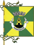
Mangualde
| Mangualde | ||||||
|---|---|---|---|---|---|---|
|
||||||
| Basic data | ||||||
| Region : | Centro | |||||
| Sub-region : | Dão-Lafoes | |||||
| District : | Viseu | |||||
| Concelho : | Mangualde | |||||
| Coordinates : | 40 ° 36 ′ N , 7 ° 46 ′ W | |||||
| Residents: | 9385 (as of June 30, 2011) | |||||
| Surface: | 35.26 km² (as of January 1, 2010) | |||||
| Population density : | 266 inhabitants per km² | |||||
| Postal code : | 3530 | |||||
| politics | ||||||
| Address of the municipal administration: | Junta de Freguesia de Mangualde Largo das Escolas, 2 3530-132 Mangualde |
|||||
| Website: | www.juntafmangualde.org | |||||
| Mangualde district | ||||||
|
||||||
| Residents: | 19,880 (as of June 30, 2011) | |||||
| Surface: | 219.27 km² (as of January 1, 2010) | |||||
| Population density : | 91 inhabitants per km² | |||||
| Number of municipalities : | 12 | |||||
| administration | ||||||
| Administration address: | Câmara Municipal de Mangualde Largo Dr. Couto 3534-004 Mangualde |
|||||
| President of the Câmara Municipal: | João Nuno Ferreira Gonçalves Azevedo ( PS ) | |||||
| Website: | www.cmmangualde.pt | |||||
Mangualde is a city and a district ( concelho ) in Portugal with 9385 inhabitants (as of June 30, 2011).
history
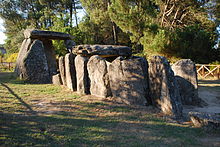
Dolmens and other finds prove a prehistoric settlement. Chief Viriathus operated here in his successful battle between the Lusitans and the Romans . After his murder in 139 BC BC Decimus Brutus also conquered this area for the Romans. Roman roads ran here, especially the road from Bracara Augusta ( Braga ) to Emerita Augusta ( Mérida ). The Romans also extracted minerals from mines.
After the invasion of the Visigoths in the 5th century AD, the Moors also conquered the area of today's Mangualde in the 8th century. They expanded the local fortress and named the place after their governor Zurara or Azurara. In the course of the Reconquista , Ferdinand I (León) conquered the place from the Arabs in 1058 .
Azurara was granted the first town charter in 1102 by D. Teresa and her son D. Afonso Henriques , who later became the first king of the country. The town received its first city rights from the Kingdom of Portugal , which has been independent since 1140, in 1217 from King D. Afonso II , which Manuel I confirmed in the course of his administrative reforms in 1514 .
During the 17th century, Azurara saw some development after the Paes do Amaral family settled here with a palace and subsequently various public institutions, including the judiciary, market, and ecclesiastical buildings and auxiliary facilities. In the 19th century, the place, now called Mangualde, took off further, especially after it was connected to the newly built road to Guarda . The origin of today's name after the disappearance of the variants of the originally Arabic name Azurara is unclear.
In 1986 the previous Vila (small town) Mangualde was elevated to a Cidade (city).
Culture and sights
Among the various architectural monuments of the city are the rococo palace Palácio Anadia (also Solar dos Pais de Amaral ) of the Paes do Amaral family from the 17th century, the L-shaped mannerist - baroque church Igreja da Misericórdia de Mangualde from the 18th century And the Cine-Teatro de Mangualde from 1947. The historic city center as a whole is also a listed building.
With the megalithic complex Anta da Cunha Baixa , the finds from the Roman villa Citânia da Raposeira from the 1st century BC. BC, and the Castro do Bom Sucesso , the castle ruins at the pilgrimage church Santuário de Nossa Senhora do Castelo , three archaeological excavation sites can be visited.
Sports
The low-class football club Grupo Desportivo de Mangualde , founded in 1945, plays its home games in the Estádio Municipal de Mangualde, which has a capacity of 1,500 .
In 2003 Mangualde was a venue for the U-17 European Football Championship .
administration
circle
Mangualde is the seat of a district of the same name. The neighboring areas are (starting clockwise in the north): Penalva do Castelo , Fornos de Algodres , Gouveia , Seia , Nelas and Viseu .
With the regional reform in September 2013, several municipalities were merged to form new municipalities, so that the number of municipalities decreased from 18 to twelve.
The following municipalities ( freguesias ) are in the Mangualde district:
| local community | Population (2011) |
Area km² |
Density of population / km² |
LAU code |
|---|---|---|---|---|
| Abrunhosa-a-Velha | 563 | 17.30 | 33 | 180601 |
| Alcafache | 921 | 12.88 | 72 | 180602 |
| Cunha Baixa | 884 | 15.52 | 57 | 180605 |
| Espinho | 984 | 14.55 | 68 | 180606 |
| Fornos de Maceira Dão | 1,459 | 16.25 | 90 | 180607 |
| Freixiosa | 257 | 7.32 | 35 | 180608 |
| Mangualde, Mesquitela e Cunha Alta | 10,407 | 46.25 | 225 | 180619 |
| Moimenta de Maceira Dão e Lobelhe do Mato | 773 | 7.15 | 108 | 180620 |
| Quintela de Azurara | 542 | 9.59 | 56 | 180614 |
| Santiago de Cassurrães e Póvoa de Cervães | 1,414 | 30.03 | 47 | 180621 |
| São João da Fresta | 208 | 7.41 | 28 | 180616 |
| Tavares (Chãs, Várzea e Travanca) | 1,468 | 35.02 | 42 | 180622 |
| Mangualde district | 19,880 | 219.27 | 91 | 1806 |
Population development
| 1801 | 1849 | 1900 | 1930 | 1960 | 1981 | 1991 | 2001 | 2011 |
| 10,216 | 12,345 | 22,340 | 23,225 | 23,311 | 21,438 | 21,808 | 20,990 | 19,880 |
Municipal holiday
- September 8th
Town twinning
economy
The Portuguese production plant of PSA Peugeot Citroën is located in Mangualde , under the name Citroën Lusitania SA On July 27, 1990, the last Citroën 2CV (known as the Duck ) was produced here. Other companies include the metalworking industry, the textile and shoe industry, a fertilizer factory belonging to the CUF group ( Companhia União Fabril ), logistics companies, furniture manufacturing and wood and stone processing . A large part is located in the Zona Industrial do Salgueiro business park .
traffic
The A35 (under construction: as of April 2010 ), which will connect the city with Mira on the Atlantic, ends in Mangualde . Furthermore, the city is on the A25 , which connects the places Gafanha da Nazaré (suburb of Barra ) and Vilar Formoso . A rail connection is available with the Linha da Beira Alta with the endpoints Vilar Formoso and Pampilhosa .
sons and daughters of the town
- João Ferreira de Almeida (1628–1691), missionary, Protestant, translator of the Bible into Portuguese
- Ana de Castro Osório (1872–1935), Republican feminist writer, children's book author and educator
- José Albuquerque (* 1916), cyclist, two-time winner of the Tour of Portugal
- Eduardo Abranches de Soveral (1927–2003), philosopher and university professor
- Jorge Coelho (* 1954), socialist politician, multiple minister
- Manuel de Oliveira (1940-2017), athlete
- José Loureiro (* 1961), painter
- Lio (* 1962), French-Belgian singer and actress
- Ricardo Jorge Marques Duarte (* 1982), football player
Web links
- Map of the Freguesia Mangualde at the Instituto Geográfico do Exército
- Official website
Individual evidence
- ↑ a b www.ine.pt - indicator resident population by place of residence and sex; Decennial in the database of the Instituto Nacional de Estatística
- ↑ a b Overview of code assignments from Freguesias on epp.eurostat.ec.europa.eu
- ↑ www.ine.pt - indicator resident population by place of residence and sex; Decennial in the database of the Instituto Nacional de Estatística
- ^ João Fonseca: Dicionário do Nome das Terras . 2nd edition, Casa das Letras, Cruz Quebrada 2007, p. 154 ( ISBN 978-9724617305 )
- ↑ www.verportugal.net , accessed July 7, 2013
- ^ History page on the city's website , accessed July 7, 2013
- ↑ www.monumentos.pt , accessed on July 7, 2013
- ↑ ditto
- ↑ ditto
- ↑ ditto
- ↑ ditto
- ↑ ditto
- ↑ www.verportugal.net , accessed July 7, 2013
- ↑ www.fussballzz.de , accessed on July 7, 2013
- ^ Publication of the administrative reorganization in the Diário da República gazette of January 28, 2013, accessed on March 16, 2014
- ↑ www.anmp.pt , accessed July 7, 2013
- ↑ Citroën Lusitania SA ( Memento of the original from June 2, 2010 in the Internet Archive ) Info: The archive link was inserted automatically and has not yet been checked. Please check the original and archive link according to the instructions and then remove this notice. , on portugalvirtual.pt, accessed on April 28, 2010
- ^ L'Alsace, November 24, 1998, Citropolis HS n ° 3 and Jacques Wolgensinger: Nous nous sommes tant aimés.
- ↑ www.cmmangualde.pt , accessed July 7, 2013


