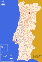
Tabuaço
| Tabuaço | ||||||
|---|---|---|---|---|---|---|
|
||||||
| Basic data | ||||||
| Region : | Norte | |||||
| Sub-region : | Douro | |||||
| District : | Viseu | |||||
| Concelho : | Tabuaço | |||||
| Coordinates : | 41 ° 7 ′ N , 7 ° 34 ′ W | |||||
| Residents: | 1782 (as of June 30, 2011) | |||||
| Surface: | 10.74 km² (as of January 1, 2010) | |||||
| Population density : | 166 inhabitants per km² | |||||
| Postal code : | 5120 | |||||
| Tabuaço district | ||||||
|
||||||
| Residents: | 6350 (as of June 30, 2011) | |||||
| Surface: | 133.85 km² (as of January 1, 2010) | |||||
| Population density : | 47 inhabitants per km² | |||||
| Number of municipalities : | 13 | |||||
| administration | ||||||
| Administration address: | Câmara Municipal de Tabuaço Rua António José de Almeida, nº 36 5120-413 Tabuaço |
|||||
| President of the Câmara Municipal: | Dr. João Joaquim Saraiva Ribeiro ( PS ) | |||||
| Website: | www.cm-tabuaco.pt | |||||
Tabuaço is a small town ( Vila ) and a district ( Concelho ) in Portugal with 1782 inhabitants (as of June 30, 2011). It belongs to the Alto Douro wine region . In 1756 this was the first protected wine region in the world and has been part of the UNESCO World Heritage since 2001 .
history
Excavations prove the prehistoric settlement. Some religious finds and the remains of a Roman road have been preserved here from the time of the Romans . In the course of the Reconquista , the place was repopulated. In 1320 the place was already an independent municipality as Tavuaço . In the 16th century it received city rights and became the seat of an independent district, which was considerably enlarged in the course of the administrative reforms of 1836–1855.
Culture and sights
The monuments of the district include a number of historical public buildings, estates and mansions , stone fountains and a variety of sacred buildings , including the São Pedro das Águias Monastery . The historic town center as a whole is also a listed building.
You can also visit the excavation of the Iron Age settlement Citânia da Longa a menhir , and parts of the local Roman road that have been preserved, all in the municipality of Longa .
Various signposted circular paths and hiking routes lead through the landscape of the UNESCO World Heritage Alto Douro , the oldest demarcated wine region in the world since 1756, which is particularly known for port wine .
The Museu do Imaginário Duriense (MIDU), opened in 2009, is the first of eleven planned museums dedicated to the history, traditions and myths of the Douro region .
administration
circle
Tabuaço is the seat of a district of the same name. The neighboring areas are (starting clockwise in the north): Sabrosa , São João da Pesqueira , Sernancelhe , Moimenta da Beira and Armamar .
With the regional reform in September 2013 , several municipalities were merged into new municipalities, so that the number of municipalities decreased from 17 to 13.
The following municipalities ( Freguesias ) are in the Tabuaço district:
| local community | Population (2011) |
Area km² |
Density of population / km² |
LAU code |
|---|---|---|---|---|
| Adorigo | 397 | 9.23 | 43 | 181901 |
| Arcos | 233 | 7.94 | 29 | 181902 |
| Barcos e Santa Leocádia | 710 | 15.21 | 47 | 181918 |
| Chavães | 385 | 9.45 | 41 | 181904 |
| Desejosa | 175 | 7.49 | 23 | 181905 |
| Granja do Tedo | 214 | 3.77 | 57 | 181906 |
| Longa | 370 | 6.83 | 54 | 181908 |
| Paradela e Granjinha | 180 | 9.05 | 20th | 181919 |
| Pinheiros e Vale de Figueira | 324 | 11.66 | 28 | 181920 |
| Sendim | 705 | 21.26 | 33 | 181913 |
| Tabuaço | 1,782 | 10.74 | 166 | 181914 |
| Távora e Pereiro | 512 | 11.94 | 43 | 181921 |
| Valença do Douro | 363 | 9.28 | 39 | 181917 |
| Tabuaço district | 6,350 | 133.85 | 47 | 1819 |
Population development
| Population in Tabuaço County (1801–2011) | |||||||||
|---|---|---|---|---|---|---|---|---|---|
| 1801 | 1849 | 1900 | 1930 | 1960 | 1981 | 1991 | 2001 | 2011 | |
| 874 | 3,952 | 9,517 | 9,362 | 11,640 | 8,521 | 7,901 | 6,785 | 6,350 | |
Municipal holiday
- June 24th
Town twinning
-
 Italy : Chiaravalle (since 1999)
Sons and daughters
- Abel Botelho (1855–1917), military, diplomat and writer, author of one of the first homosexual novels in Europe
Web links
- Map of the Freguesia Tabuaço at the Instituto Geográfico do Exército
- Official website
Individual evidence
- ↑ www.ine.pt - indicator resident population by place of residence and sex; Decennial in the database of the Instituto Nacional de Estatística
- ↑ a b Overview of code assignments from Freguesias on epp.eurostat.ec.europa.eu
- ↑ www.ine.pt - indicator resident population by place of residence and sex; Decennial in the database of the Instituto Nacional de Estatística
- ↑ www.cm-tabuaco.pt , accessed on February 22, 2013
- ↑ www.monumentos.pt (under Cronologia ), accessed on February 23, 2013
- ↑ ditto
- ↑ ditto
- ↑ ditto
- ↑ ditto
- ↑ www.cm-tabuaco.pt , accessed on February 23, 2013
- ^ Publication of the administrative reorganization in the Diário da República gazette of January 28, 2013, accessed on March 16, 2014
- ↑ www.anmp.pt , accessed on February 22, 2013


