
Vila Real
| Vila Real | ||||||
|---|---|---|---|---|---|---|
|
||||||
| Basic data | ||||||
| Region : | Norte | |||||
| Sub-region : | Douro | |||||
| District : | Vila Real | |||||
| Concelho : | Vila Real | |||||
| Coordinates : | 41 ° 18 ′ N , 7 ° 45 ′ W | |||||
| Residents: | 51,850 (as of June 30, 2011) | |||||
| Surface: | 378.81 km² (as of January 1, 2010) | |||||
| Population density : | 137 inhabitants per km² | |||||
| Height: | 460 m | |||||
| Vila Real district | ||||||
|
||||||
| Residents: | 51,850 (as of June 30, 2011) | |||||
| Surface: | 378.81 km² (as of January 1, 2010) | |||||
| Population density : | 137 inhabitants per km² | |||||
| Number of municipalities : | 20th | |||||
| administration | ||||||
| Website: | www.cm-vilareal.pt | |||||


Vila Real is a city in Portugal and the administrative seat of the district of the same name. It is located in the north of the country on a mountain plateau (approx. 460 m), surrounded by the Marão and Alvão mountain ranges . The old town is bounded by the Corgo and Cabril rivers . The Circuito de Vila Real motorcycle race is held in Vila Real every year .
history
Presumably the area of today's Vila Real was already settled in the Paleolithic . Traces of the Roman settlers can still be seen today (e.g. in the monastery of Rupestre de Panóias ). However, with the beginning of the great migration and the invasion of Arab tribes , the area became depopulated.
In the twelfth century, Constantim de Panóias was commissioned by Count D. Henrique to take over the administration (and thus the repopulation). In 1289 the Portuguese king Dom Dinis founded the city "Vila Real de Panóias", today's Vila Real. The city's privileged location on the major roads Porto - Bragança and Viseu - Chaves guaranteed continuous growth. From the 17th century on, many noble families also settled down, giving the old town its typical face today.
In 1922 the diocese of Vila Real was founded from parts of the dioceses of Braga, Lamego and Bragança-Miranda. It wasn't until 1925, however, that Vila Real was officially declared a city.
In recent years there has been great progress in establishing a cultural scene, among other things through the construction of a theater and a music conservatory. The new construction and expansion of the district library and the city archive can also be counted here. In addition, a number of urban development measures were carried out, such as B. Greening through parks in the old district of Bairro dos Ferreiros and the promenade along the Corgo River .

administration
Vila Real is the seat of a district of the same name and the administrative seat of the district of the same name . The extension is 377.67 km², which is shared by 49,957 people (as of 2001). The neighboring areas are (starting clockwise in the north): Ribeira de Pena , Vila Pouca de Aguiar , Sabrosa , Peso da Régua , Santa Marta de Penaguião , Amarante , and Mondim de Basto .
With the regional reform in September 2013 , several municipalities were merged into new municipalities, so that the number of municipalities decreased from 30 to 20.
The following municipalities ( freguesias ) are in the Vila Real district:

| local community | Population (2011) |
Area km² |
Density of population / km² |
LAU code |
|---|---|---|---|---|
| Abaças | 965 | 18.87 | 51 | 171401 |
| Adoufe e Vilarinho de Samardã | 2,895 | 37.76 | 77 | 171431 |
| Andrães | 1,389 | 20.47 | 68 | 171403 |
| Arroios | 1,117 | 2.89 | 386 | 171404 |
| Borbela e Lamas de Olo | 2,761 | 41.28 | 67 | 171432 |
| Campeã | 1,375 | 24.05 | 57 | 171406 |
| Constantim e Vale de Nogueiras | 1,856 | 26.01 | 71 | 171433 |
| Folhadela | 2,261 | 16.06 | 141 | 171409 |
| Guiães | 478 | 8.57 | 56 | 171410 |
| Lordelo | 3,169 | 5.16 | 614 | 171414 |
| Mateus | 3,400 | 4.14 | 821 | 171415 |
| Mondrões | 1,065 | 11.04 | 96 | 171416 |
| Mouçós e Lamares | 3,402 | 32.24 | 106 | 171434 |
| Nogueira e Ermida | 964 | 11.96 | 81 | 171435 |
| Parada de Cunhos | 1.939 | 7.04 | 275 | 171420 |
| Pena, Quinta e Vila Cova | 819 | 24.98 | 33 | 171436 |
| Sao Tome do Castelo e Justes | 1,283 | 41.56 | 31 | 171437 |
| Torgueda | 1,382 | 14.43 | 96 | 171426 |
| Vila Marim | 1,742 | 23.21 | 75 | 171429 |
| Vila Real | 17,588 | 7.09 | 2,480 | 171438 |
| Vila Real district | 51,850 | 378.81 | 137 | 1714 |
| 1801 | 1849 | 1900 | 1930 | 1960 | 1981 | 1991 | 2001 | 2008 | ||
| 37,041 | 25,329 | 35,976 | 37,951 | 47,773 | 47.020 | 46,300 | 49,957 | 50.131 | ||
| Note: the Vila Real district was changed several times in the 19th century. | ||||||||||
Pictures of the city
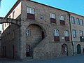
Birthplace of Diogo Cão

Pillory in front of the São Domingos church

Typical alley in the old town

Mateus Palace near Vila Real


Town twinning
Vila Real maintains city partnerships with the following cities:
-
 Osnabrück ( Germany )
 -
 Ourense ( Spain )
 -
 Grasse ( France )
 -
Mende ( France )
-
 Oeiras ( Portugal )
 -
Portimão ( Portugal )
The city friendship with Osnabrück was launched in 1989 and officially expanded into a city partnership in July 2005. As an expression of solidarity, there is an Avenida de Osnabrück in Vila Real.
university
In the northern Portuguese city of Vila Real there is the State University Trás-os-Montes and Alto Douro (UTAD). The university was founded in 1986 (on March 22, 2006 it celebrated its 20th anniversary). At this university you can a. Study applied foreign languages, biology , chemistry , forestry , engineering , economics , oenology , communication studies , landscape architecture , mathematics , sports , theater studies , veterinary medicine and environmental sciences. Some courses are not offered in Vila Real, but only at the UTAD branch in Chaves (e.g. tourism). In the academic year 2009/10, around 7,000 students studied at UTAD. The following foreign languages are taught at the university: German , English , French and Spanish .
traffic
.jpg)
Vila Real had a train station on the Linha do Corgo . The Portuguese rail network operator Rede Ferroviária Nacional suspended traffic on the meter- gauge route in March 2009. A reopening was originally planned, but is now considered unlikely. The nearest train station is a good 25 kilometers away in Peso da Régua ( Linha do Douro ).
The airport Vila Real with a 950 m long runway is about 4 km from the city . There are daily flights to Lisbon and Bragança , u. a. through the Aero VIP .
Distances to known places
- Porto Airport - 100 km
- Porto - 97 km
- Lisbon - 411 km
- Braga - 100 km
- Chaves - 68 km
- Bragança - 120 km
- Viseu - 90 km
-
Madrid Spain - 520 km
climate
Due to its geographical position (the Marão and Alvão mountain ranges act as natural barriers), Vila Real has extreme weather conditions: winters are long and unusually cold, with at least one snowfall in most years. In contrast, the summer is very hot. Moderate temperatures are only measured on a few days throughout the year. The vernacular says "Nove meses de Inverno, três meses de inferno" (literally translated "nine months of winter, three months of hell").
| Climatic table Vila Real | ||||||||||||||
|---|---|---|---|---|---|---|---|---|---|---|---|---|---|---|
| Temperatures | ||||||||||||||
| month | Jan | Feb | Mar | Apr | May | Jun | Jul | Aug | Sep | Oct | Nov | Dec | medium | |
| Highest measured temperature ° C | 19.1 | 23.7 | 28.2 | 31.6 | 34.4 | 38.5 | 41.4 | 40.4 | 37.6 | 32.3 | 24.4 | 20.6 | ||
| Highest mean ° C | 10.2 | 12.3 | 15.3 | 18.2 | 20.7 | 25.7 | 29.1 | 29.3 | 25.7 | 20.2 | 14.2 | 10.5 | 19.3 | |
| Middle ° C | 6.2 | 7.4 | 10.2 | 12.6 | 14.9 | 19.0 | 21.4 | 21.6 | 19.1 | 14.4 | 9.7 | 6.6 | 13.6 | |
| Lowest mean ° C | 2.3 | 2.6 | 5.2 | 6.9 | 9.1 | 12.2 | 13.8 | 13.9 | 12.5 | 8.7 | 5.2 | 2.7 | 7.9 | |
| Lowest measured temperature ° C | −7.2 | −6.3 | −5.6 | −2.0 | 0.0 | 4.0 | 6.5 | 6.1 | 2.4 | −1.7 | −5.2 | −6.8 | ||
| Precipitation | ||||||||||||||
| month | Jan | Feb | Mar | Apr | May | Jun | Jul | Aug | Sep | Oct | Nov | Dec | Total | |
| Total mm | 156.5 | 110.4 | 145.6 | 77.3 | 61.2 | 31.5 | 10.2 | 15.5 | 38.4 | 83.6 | 129.8 | 158.8 | 1018.8 | |
| Data collected between 1931 and 1960 . | ||||||||||||||
Trivia
Vila Real was the first Portuguese city to have electric light.
Hiking trails at Vila Real
Ecotourism is now very popular as an alternative to spending free time in northern Portugal. The region around Vila Real is no exception, where you can find hiking trails and admire the wonderful landscape heritage. In 2005 a project was developed in Vila Real to mark and classify five hiking trails (see also Hiking in Portugal ). All marked hiking trails are classified as "short", i. i.e., they are less than 30 kilometers long. In fact, these paths are between three and twelve kilometers long and they always start in the center of a village.
These are the five marked hiking trails in the area around Vila Real:

- The "Three Villages" circuit -
- Location: Linhares / Águas Santas / Vila Mea / Linhares
- Length: 6 kilometers - Estimated walking time: 2.5 hours
- Difficulty level: low
- The "Constantim" hiking trail -
- Location: Constantim / Santuário de Panóias / Assento / Constantim
- Length: 3 kilometers - Estimated walking time: 1.5 hours
- Difficulty level: low
- Note: Santuário de Panóias is a prehistoric sanctuary, the archaeological site can be visited.
- The "Carvalhal" circuit -
- Location: S.Miguel da Pena / Vilarinho / Capela de Nossa Senhora de Fátima / Gontaes / Vilarinho / S.Miguel da Pena
- Length: 5 kilometers - Estimated walking time: 2 hours
- Difficulty level: low / medium
- The way of the "miner" -
- Location: Vila Cova / Mascoselo / Vila Cova
- Length: 12 kilometers - Estimated walking time: 4 hours
- Difficulty level: medium / high
- The way of the "wolf" -
- Location: Samarda / Fojo do Lobo / Samarda
- Length: 6 kilometers - Estimated walking time: 2 hours
- Difficulty level: low
- Note: Fojo do Lobo ("Wolf Trap") was an oval 3 meter high fence that was used to capture wolves and protect the herd (goats and sheep).
Personalities
- Diogo Cão († around 1486), navigator and explorer
- Camilo Castelo Branco (1825–1890), writer, novelist, critic, poet and translator
- Fernando Mesquita (1916– in the 1990s), architect in Mozambique
- António Montes Moreira (* 1935), former bishop of Bragança
- Luís Castro (* 1961), football coach
- Delmino Pereira (* 1967), cyclist and sports official
- Paulo Martins Alves (* 1969), football player
- Simão Sabrosa (* 1979), football player
Culinary
The gastronomy is known for the rich desserts, such as "Toucinho do Céu" (Ham of Heaven), "Pitos de Santa Luzia" (Chick of St. Luzia) and the "Ganchas de S. Brás" (Beard of St. Brás) . The latter two have a special tradition: on December 13th the young women of the city present their chosen ones with a “chick”, while the young men return the favor on February 3rd with the “beards”. Traditional dishes from Vila Real are also the “Tripas aos mohlos” (spicy pork offal), roast lamb with rice cooked in a stone oven, roasted veal and, of course, variously prepared cod (stockfish). The “Bolas de Carne” (meat baked in bread) are known and sought-after nationwide.
Cultural calendar
- Saint Brás , February 2nd and 3rd
- São Lázaro , the Sunday before Palm Sunday
- Academic week, early May
- Saint Anthony , patron saint of the city, June 13th (official holiday in Vila Real)
- São João , June 24th, with numerous parades throughout the city
- São Pedro , June 28th and 29th. Products from handicraft businesses are offered (especially clay work)
- Procession Corpo de Deus , in June
- Procession of the Blessed Virgin de Almodena, September 8th
- Festa da Senhora da Pena , first week of September
- Reception of the freshmen, with a variety of games and activities. Numerous music concerts take place in the evenings. End of October / beginning of November
- Santa Luzia , December 13th
Web links
swell
- ↑ a b www.ine.pt - indicator resident population by place of residence and sex; Decennial in the database of the Instituto Nacional de Estatística
- ↑ a b Overview of code assignments from Freguesias on epp.eurostat.ec.europa.eu
- ^ Publication of the administrative reorganization in the Diário da República gazette of January 28, 2013, accessed on March 16, 2014
- ^ INE (2007) "Annual Statistics of the North Region (2006)" , p. 45.
- ^ INE (2003) "Recenseamento da População e da Habitação (Norte) - Censos 2001" , pp. 130.
- ↑ In the north of Portugal at www.osnabrueck.de, accessed on June 19, 2018
- ↑ University website: http://www.utad.pt
- ↑ Carlos Cipriano: Refer encerra linhas do Corgo do Tâmega e sem aviso previo aos utentes do serviço. Público, March 25, 2009, accessed May 14, 2014 (Portuguese).
- ^ Almeida Cardoso: Exigem regresso dos comboios. Correio da Manhã, April 3, 2011, accessed May 14, 2014 (Portuguese).
- ↑ Aeródromo em Portugal - VILA REAL ( Memento of the original from June 10, 2015 in the Internet Archive ) Info: The archive link has been inserted automatically and has not yet been checked. Please check the original and archive link according to the instructions and then remove this notice.
