Linha do Corgo
| Régua – Chaves | |||||||||||||||||||||||||||||||||||||||||||||||||||||||||||||||||||||||||||||||||||||||||||||||||||||||||||||||||||||||||||||||||||||||||||||||||||||||||
|---|---|---|---|---|---|---|---|---|---|---|---|---|---|---|---|---|---|---|---|---|---|---|---|---|---|---|---|---|---|---|---|---|---|---|---|---|---|---|---|---|---|---|---|---|---|---|---|---|---|---|---|---|---|---|---|---|---|---|---|---|---|---|---|---|---|---|---|---|---|---|---|---|---|---|---|---|---|---|---|---|---|---|---|---|---|---|---|---|---|---|---|---|---|---|---|---|---|---|---|---|---|---|---|---|---|---|---|---|---|---|---|---|---|---|---|---|---|---|---|---|---|---|---|---|---|---|---|---|---|---|---|---|---|---|---|---|---|---|---|---|---|---|---|---|---|---|---|---|---|---|---|---|---|
|
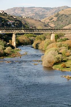
Railway bridge over the Rio Corgo
| |||||||||||||||||||||||||||||||||||||||||||||||||||||||||||||||||||||||||||||||||||||||||||||||||||||||||||||||||||||||||||||||||||||||||||||||||||||||||
| Route length: | 96.2 km | ||||||||||||||||||||||||||||||||||||||||||||||||||||||||||||||||||||||||||||||||||||||||||||||||||||||||||||||||||||||||||||||||||||||||||||||||||||||||
| Gauge : | 1000 mm ( meter gauge ) | ||||||||||||||||||||||||||||||||||||||||||||||||||||||||||||||||||||||||||||||||||||||||||||||||||||||||||||||||||||||||||||||||||||||||||||||||||||||||
|
|||||||||||||||||||||||||||||||||||||||||||||||||||||||||||||||||||||||||||||||||||||||||||||||||||||||||||||||||||||||||||||||||||||||||||||||||||||||||
The Linha do Corgo is a railway line in the north of Portugal and branches off the main line Linha do Douro near Régua. The route between Régua and Chaves was the first railway line to be constructed and operated in Portugal. The route overcomes a height difference of 370 meters in the first 25 km between Régua and Vila Real. On January 1, 1990, operations between Chaves and Vila Real ceased, and the remaining section followed on March 24, 2009.
history
A lightweight train with a track width of only 1000 mm was required for the route. In the years between 1875 and 1876, the trains on the route between Régua and Vila Real were still pulled by horse power.
The construction of the line and its operation was partially supported by the Companhia Vinícola de Portugal , which was later dissolved and then the Companhia dos Caminhos de Ferro Portugueses took over the operation. The Linha do Corgo was put into operation in the following stages:
- Régua — Vila Real: May 12, 1906
- Vila Real — Pedras Salgadas: July 15, 1907
- Pedras Salgadas-Vidago: March 20, 1910
- Vidago-Tâmega: June 20, 1919
- Tâmega-Chaves: August 28, 1921
The Chaves terminus was designed to meet three railway lines here: the Linha do Corgo, the Linha do Tâmega and a line from Guimarães . The planned Linha de Guimarães never got beyond Fafe train station and the Linha do Tâmega never made it to Chaves either.
At the end of the 1980s, the Linha do Corgo was divided into two parts: Régua – Vila Pouca de Aguiar, and Vila Pouca de Aguiar to Chaves. The last regular timetables for the entire 96 km route provided for four departures, two in each direction. Even then, there was more demand for the route from Régua to Vila Pouca de Aguia. On January 1, 1990, the section from Vila Pouca de Aguiar to Chaves was discontinued.
On March 24, 2009, the infrastructure operator REFER temporarily suspended traffic on the route. The reason given is security deficiencies. Customers fear a longer-term setting similar to the Bragança – Mirandela section on the Linha do Tua , which has been closed since 1991. Since the temporary closure, the line has been completely modernized, which includes, among other things, the renovation of the stations and stops, the rails and the substructure. The costs amount to a total of 23.4 million euros, the route should probably be reopened at the end of 2010 when the timetable changes.
The line is now considered to be closed and has been completely dismantled. The population of the region continues to call for the route to be reopened, and a citizens' initiative called Movimento Cívico pela Linha do Corgo is promoting a reopening. So far, however, no information has been given by the official authorities. In 2019, the citizens' initiative advertised that reconstruction would only cost eleven million euros and that the route would be sustained through ticket sales, freight traffic, tourist charter traffic and converting the stations into overnight accommodations.
literature
- Herbert Stemmler: The narrow-gauge railways in northern Portugal . In: Wolfgang Messerschmidt (Ed.): Locomotive magazine . No. 68 . Franckh'sche Verlagshandlung, W. Keller & Co. , 1974, ISSN 0458-1822 , p. 372-384 .
Individual evidence
- ↑ Carlos Cipriano: Refer encerra linhas do Corgo do Tâmega e sem aviso previo aos utentes do serviço. Público, March 25, 2009, accessed May 14, 2014 (Portuguese).
- ↑ Eduardo Pinto: Linha do Corgo reabre no final de 2010. Jornal de Notícias, July 22, 2009, accessed on May 14, 2014 (Portuguese).
- ^ Almeida Cardoso: Exigem regresso dos comboios. Correio da Manhã, April 3, 2011, accessed May 14, 2014 (Portuguese).
- ↑ Manuel Jorge Bento: Reativar Linha do Corgo é possível com 11 milhões de euros. In: Correio da Manhã. April 7, 2019, accessed April 8, 2019 (Portuguese).

