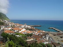
Povoação
| Povoação | ||||||
|---|---|---|---|---|---|---|
|
||||||
| Basic data | ||||||
| Autonomous Region : | Azores | |||||
| Concelho : | Povoação | |||||
| Coordinates : | 37 ° 45 ′ N , 25 ° 15 ′ W | |||||
| Residents: | 2161 (as of June 30, 2011) | |||||
| Surface: | 26.23 km² (as of January 1, 2010) | |||||
| Population density : | 82 inhabitants per km² | |||||
| Postal code : | 9650 | |||||
| Povoação district | ||||||
|
||||||
| Residents: | 6327 (as of June 30, 2011) | |||||
| Surface: | 106.41 km² (as of January 1, 2010) | |||||
| Population density : | 59 inhabitants per km² | |||||
| Number of municipalities : | 6th | |||||
| administration | ||||||
| Administration address: | Câmara Municipal de Povoação Largo do Municipio Nº1 9650-411 |
|||||
| President of the Câmara Municipal: | Carlos Emílio Lopes Machado Avila ( PS ) | |||||
| Website: | www.cm-povoacao.pt | |||||
Povoação ( [ puvuɐˈsɐ̃w ] ) is a small town ( Vila ) and a district ( Concelho ) on the island of São Miguel ( Azores ) . On June 30, 2011, the city had 2,161 inhabitants on an area of 26.2 km².
history
After a first landing in 1427 , Povoação ( Portuguese for locality) began to be colonized in 1432 . After further localities had emerged in the further course, Povoação belonged to the district of Vila Franca do Campo . After it later belonged to the Nordeste district , it became the seat of an independent district in 1839 .
Culture and sights
The important botanical Terra Nostra Park and the thermal baths of the Estação Termal das Furnas in the municipality of Furnas are in a circle. With the Furnas Lake , the second largest lake in the Azores is located in the district.
The architectural monuments in the district include the Terra Nostra Park with the thermal bath, various public buildings and a number of sacred buildings . The manor house Casa das Murtas with its park is one of them. In addition, the historic center of Povoação is a listed building as a whole.
The district has several museums, including the Museu do Trigo and the Núcleo Museológico da Ribeira Quente . With the Parque Zoológico da Vila da Povoação there is also a zoo to visit.
administration
circle
Povoação is the seat of a district of the same name ( concelho ). The neighboring areas are:
| Ribeira Grande | Northeast | |
| Vila Franca do Campo |

|
Atlantic Ocean |
| Atlantic Ocean |
The following six parishes belong to the Povoação district:
| local community | Population (2011) |
Area km² |
Density of population / km² |
LAU code |
|---|---|---|---|---|
| Água Retorta | 489 | 12.55 | 39 | 420401 |
| Faial da Terra | 359 | 11.38 | 32 | 420402 |
| Furnas | 1,439 | 34.43 | 42 | 420403 |
| Nossa Senhora dos Remédios | 1,112 | 12.78 | 87 | 420404 |
| Povoação | 2.161 | 26.23 | 82 | 420405 |
| Ribeira Quente | 767 | 9.04 | 85 | 420406 |
| Povoação district | 6.327 | 106.41 | 59 | 4204 |
Population development
| Population in the Povoação district (1849–2011) | |||||||||
| year | 1849 | 1900 | 1930 | 1960 | 1981 | 1991 | 2001 | 2011 | |
|---|---|---|---|---|---|---|---|---|---|
| Residents | 10,558 | 11,087 | 12,318 | 15,064 | 8,458 | 7,323 | 6,726 | 6.327 | |
Municipal holiday
- 3rd of July
Town twinning
-
 Portugal : São Miguel
 -
 United States : Dartmouth (Massachusetts)
-
 United States : Fall River (Massachusetts)
education
In Povoação there is a primary school, a secondary school and a grammar school.
Web links
Individual evidence
- ↑ a b www.ine.pt - indicator resident population by place of residence and sex; Decennial in the database of the Instituto Nacional de Estatística
- ↑ a b Overview of code assignments from Freguesias on epp.eurostat.ec.europa.eu
- ↑ www.ine.pt - indicator resident population by place of residence and sex; Decennial in the database of the Instituto Nacional de Estatística
- ↑ www.monumentos.pt (under Cronologia ), accessed on August 28, 2013
- ↑ www.monumentos.pt , accessed on August 28, 2013
- ↑ ditto
- ↑ www.anmp.pt , accessed on August 28, 2013


