Lajes do Pico
| Lajes do Pico | ||||||
|---|---|---|---|---|---|---|
|
||||||
| Basic data | ||||||
| Autonomous Region : | Azores | |||||
| Concelho : | Lajes do Pico | |||||
| Coordinates : | 38 ° 24 ′ N , 28 ° 14 ′ W | |||||
| Residents: | 1802 (as of June 30, 2011) | |||||
| Surface: | 53.09 km² (as of January 1, 2010) | |||||
| Population density : | 34 inhabitants per km² | |||||
| Postal code : | 9930-127 | |||||
| politics | ||||||
| Mayor : | Manuel Francisco Dutra ( PS ) | |||||
| Address of the municipal administration: | Junta de Freguesia de Lajes do Pico Lg General Lacerda Machado, 1 9930 - 127 Lajes do Pico |
|||||
| Website: | www.lajesdopico.freguesias.pt | |||||
| Lajes do Pico district | ||||||
|
||||||
| Residents: | 4711 (as of June 30, 2011) | |||||
| Surface: | 155.31 km² (as of January 1, 2010) | |||||
| Population density : | 30 inhabitants per km² | |||||
| Number of municipalities : | 6th | |||||
| administration | ||||||
| Administration address: | Câmara Municipal de Lajes do Pico Rua de São Francisco 9930-135 Lajes do Pico |
|||||
| President of the Câmara Municipal: | Roberto Silva ( PS ) | |||||
| Website: | www.cm-lajesdopico.pt | |||||
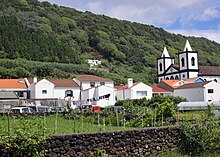
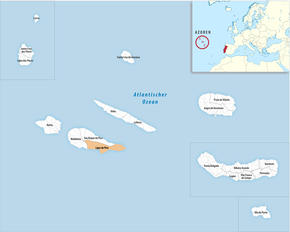
Lajes do Pico ( [ ˈlaʒɨʒ ðu ˈpiku ] ) is a small town (Vila) on the Portuguese island of Pico , part of the Azores archipelago . On June 30, 2011, the city had 1802 inhabitants on an area of 53.1 km².
geography
The city is located on the south coast of the island. The terrain is mountainous in the northern part and flatter towards the south until it finally reaches the Atlantic . The only road that connects the northern and southern parts of the island is through the island's mountains.
history
The island of Pico was settled from 1460. Around 1500 a number of men were already living in Lajes, so that in 1501 the place became the seat of the newly established district administration of the island. The district of Lajes comprised the entire island until the district of São Roque do Pico was created in 1542 and, in 1723, the district of Madalena was created through splits and reorganizations.
After wheat and coloring plants were initially grown, the island turned to wine production from the 16th century. This became the main export good until powdery mildew infestation caused viticulture to decline in the 19th century .
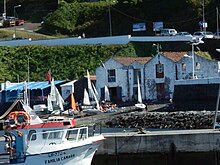
From the 18th century onwards, whaling became the most important and well-known activity on the island. Lajes do Pico became a main whaling base in the Azores. In 1984 professional whaling ceased in the Azores. In 1987 the last whale was caught and in 1988 a museum dedicated to the history of whaling opened in Lajes. A year later, the Frenchman Serge Viallelle opened Espaço Talassa, the first whale watching station in the Azores in Lajes do Pico.
administration
circle
Lajes do Pico is the administrative seat of a district of the same name ( concelho ). The two other districts of the island are São Roque do Pico in the north and Madalena in the west . The following municipalities ( Freguesias ) are in the district:
| local community | Population (2011) |
Area km² |
Density of population / km² |
LAU code |
|---|---|---|---|---|
| Calheta de Nesquim | 343 | 13.81 | 25th | 460101 |
| Lajes do Pico | 1,802 | 53.09 | 34 | 460102 |
| Piedade | 844 | 12.81 | 66 | 460103 |
| Ribeiras | 925 | 34.17 | 27 | 460104 |
| Ribeirinha | 374 | 8.49 | 44 | 460105 |
| São João | 423 | 32.94 | 13 | 460106 |
| Lajes do Pico district | 4,711 | 155.31 | 30th | 4601 |
Population development
| Population in Lajes do Pico County (1849–2011) | |||||||||
| year | 1849 | 1900 | 1930 | 1960 | 1981 | 1991 | 2001 | 2004 | 2011 |
|---|---|---|---|---|---|---|---|---|---|
| Residents | 11480 | 9371 | 7796 | 8186 | 5828 | 5563 | 5041 | 4840 | 4711 |
Municipal holiday
- June 29th
Town twinning
-
 Portugal : Machico , Madeira Island
-
 Spain : Betancuria , Canary Island Fuerteventura
-
 Spain : Cangas de Morrazo , Galicia
sons and daughters of the town
- Anselmo Silveira da Silva (1833–1912), whaling entrepreneur in the USA and the Azores
- João Paulino de Azevedo e Castro (1852–1918), Bishop of Macau
- Amaro de Azevedo Gomes (1852–1928), military and republican politician, 1910/1911 Navy and Overseas Minister
- Francisco Soares de Lacerda Machado (1870–1955), military, historian, ethnographer and author
- José Vieira Alvernaz (1898–1986), Archbishop of Goa
Web links
gallery
Typical Portuguese pavement ( Calçada Portuguesa ), in the streets of Lajes do Pico
Individual evidence
- ↑ a b www.ine.pt - indicator resident population by place of residence and sex; Decennial in the database of the Instituto Nacional de Estatística
- ↑ a b Overview of code assignments from Freguesias on epp.eurostat.ec.europa.eu
- ↑ www.ine.pt - indicator resident population by place of residence and sex; Decennial in the database of the Instituto Nacional de Estatística
- ^ First history page on the district's website , accessed on August 26, 2013
- ↑ Second history page on the district's website , accessed on August 26, 2013
- ↑ Into the blue of the Azores: It's even easier for whale-watchers to catch one of the planet's great spectacles , Independent, April 6, 2012
- ↑ www.anmp.pt , accessed on August 26, 2013
- ↑ J. Santos: Cangas y Lajes do Pico sellaron ayer los lazos de hermanamiento , La Voz de Galicia, May 18, 2003, accessed on February 7, 2019 (Spanish).


