Santa Cruz da Graciosa
| Santa Cruz da Graciosa | ||||||
|---|---|---|---|---|---|---|
|
||||||
| Basic data | ||||||
| Autonomous Region : | Azores | |||||
| Concelho : | Santa Cruz da Graciosa | |||||
| Coordinates : | 39 ° 5 ′ N , 28 ° 1 ′ W | |||||
| Residents: | 1776 (as of June 30, 2011) | |||||
| Surface: | 15.52 km² (as of January 1, 2010) | |||||
| Population density : | 114 inhabitants per km² | |||||
| Postal code : | 9880-352 | |||||
| politics | ||||||
| Mayor : | João Manuel Teixeira Bettencourt ( PS ) | |||||
| Address of the municipal administration: | Junta de Freguesia de Santa Cruz da Graciosa Rua Infante D. Henrique 50 9880-352 Santa Cruz da Graciosa |
|||||
| Website: | www.jf-santacruz.com | |||||
| Santa Cruz da Graciosa County | ||||||
|
||||||
| Residents: | 4391 (as of June 30, 2011) | |||||
| Surface: | 60.66 km² (as of January 1, 2010) | |||||
| Population density : | 72 inhabitants per km² | |||||
| Number of municipalities : | 4th | |||||
| administration | ||||||
| Administration address: | Câmara Municipal de Santa Cruz da Graciosa Largo Vasco da Gama, n.º 4 9880-352 Santa Cruz da Graciosa |
|||||
| President of the Câmara Municipal: | Manuel Avelar Cunha Santos ( PS ) | |||||
| Website: | www.cm-graciosa.pt | |||||
Santa Cruz da Graciosa ( [ ˈsɐ̃tɐ ˈkɾuʒ ðɐ ɣɾɐsiˈɔzɐ ] ) is a small town ( Vila ) with 1776 inhabitants (as of June 30, 2011) on the Azores island of Graciosa , Portugal .
history
When the island was taken over by the Kingdom of Portugal in 1439, the colonization of Graciosa began in 1450 by the families of the two settlers Pedro Correia da Cunha from Porto Santo (allegedly a later brother-in-law of Christopher Columbus ) and Vasco Gil Sodré , a nobleman from Montemor -o-Velho .
In 1486 the Santa Cruz district was established as the official administrative unit for the entire island area.
architecture
Among the most striking buildings in Santa Cruz are the Fortim da Calheta fortress, built in the 18th century to protect against pirate attacks, and the three-aisled church Igreja de Santa Cruz , built in the 16th century and enlarged in 1701 . It has a length of 26.35 m and a width of 12.6 m. The tower was added later and completed in 1732. In addition to the main altar, there are ten side altars in the church. The oldest of the side chapels is the Gothic baptistery with a Manueline vault and a stone baptismal font. The significantly smaller church Igreja da Misericordia from the 16th century covers a floor area of 5.46 × 20.90 m and is generally kept simpler. Next to it is the former monastery complex of Ermida de São Pedro , which was first mentioned in 1559 as the second oldest monastery on the island and is possibly even older than the main church Igreja de Santa Cruz. The buildings of the monastery were profaned in 1833 and served at times as a warehouse, later as a primary school and then as a cinema or theater. At the beginning of the 21st century, the buildings were renovated and have been used for residential purposes ever since.
On the main square in the center of the village, popularly known as "Rossio" based on the square of the same name in Lisbon, where there is a small park with a pavilion, two extensive, shallow water basins were created, which originally served to supply the residents with drinking water and as a cattle trough. Not far from the square, an isolated church tower ( Torre da Igreja de Nossa Senhora dos Anjos ) protrudes from the city center. It is the last remnant of a Franciscan monastery founded in 1700 and dissolved in 1834, whose church, built in 1700–1708, was demolished in 1946 except for the tower. The stones have been reused in the construction of many homes in Santa Cruz.
The Ermida de Santo António chapel, built around the middle of the 17th century, with a strikingly low tower, is located in the small square of Praça de Santo António in the center of Santa Cruz. Its base measures 15.83 m × 5.57 m. In the chapel there is the grave of the founder, Sargento António der Freitas Correia, and a statue of Saint Rita. Another chapel, the somewhat smaller Ermida do Corpo Santo , was built at the end of the 17th / beginning of the 18th century at the port in the immediate vicinity of the Fortim da Calheta fortress with a floor area of 14.90 × 4.72 m. The chapel, in which colorful altar paintings from 1925 can be viewed, is particularly easy to see from the sea. In 2003 the chapel, in the facade of which the year 1878 refers to a partial renovation, was renovated, with the costs being borne by the inhabitants of the town - especially the fishermen.
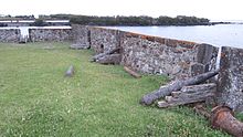
In the southern district of Porto da Barra stands the 5 m high stone cross Cruz da Barra , built in 1520 in the Manueline style . On the south-eastern outskirts of Porto da Barra, the former port of the city, rises the fortress Forte da Barra , whose surrounding walls and battlements are well preserved. Eight cannons can be seen in it in varying degrees of preservation. Around 600 m further south are the ruins of the Forte de Santa Catarina fortress by the sea , of which only a few remains of the wall are evidence.
Not far from the ruins of the fortress Forte de Santa Catarina is the rectangular, walled tomb of Cemitério Hebreu made of basalt with the inscription "Cemiterio Judaico". Its length is 5.90 m and its width is 3.90 m.
Districts
The following districts belong to the city of Santa Cruz da Graciosa:
- Rebentão . Here there is a chapel of the Holy Spirit, the court of justice of the island of Graciosa and the Graciosas secondary school.
- Santo Amaro , where the island's hospital opened in 2012, various authorities and a chapel of the Holy Spirit are located. The place is also known for the 1693-1705 built on the private property of a captain, 9.4 m long and 4.6 m wide chapel Ermida de Santo Amaro . It has a strikingly large, brick forecourt and a garden.
- Fontes originated around some of the few springs on the island at a height of 120-180 m. ü. d. M. The town's Holy Spirit Chapel has a distinctive undulating gable on which the figure of a dove was placed as a symbol of the Holy Spirit.
- Funchais is about 2 km west of the city. Around the place, in the middle of which a chapel of the Holy Spirit was built on a stone pedestal, three volcanic cones loom up: Pico do Barroso (122 m), Pico do Jardim (101 m) and the 124 m high Pico da Hortelã .
- Dores , which is not far south of the airport on the island of Graciosa and north of the Pico do Jardim mountain , is best known for the Ermida de Nossa Senhora das Dores chapel, built in 1793 , next to which there is another chapel of the Holy Spirit. The headquarters of the island's volunteer fire brigade and the headquarters of the agricultural cooperative are also located in the village .
- Cruz do Bairro is one of the smallest districts of the city and is characterized by viticulture.
- Bom Jesus is located in the north of the island, northeast of the 156 m high mountain Pico das Bichas . The place is best known for the 11 m long and 5 m wide chapel of Ermida do Bom Jesus , first mentioned in a document in 1636 , which was possibly built towards the end of the 16th century and rebuilt in 1786 and 1902. The chapel was damaged in the 1980 earthquake and then renovated with donations from the local population and emigrants. After another renovation in 2003, which was also done with donations, it is now in a very good state of preservation.
- Barro Vermelho is one of the smallest districts and is located in the north of the island not far from Graciosa Airport . The place has one of the few beaches on the island, a campsite and several summer houses.
- Terreiros is another small district in the north of Graciosa.
- Quitadouro is located south of the city on the mountain of the same name (213 m). A new industrial area ( Parque Industrial da Graciosa ) is planned here.
- Covas is a district southwest of the city at the foot of the mountain Pico da Hortelã (124 m).
Surroundings
To the south of the city rises the 129 m high Monte da Ajuda, on which three hermit chapels were built. Monte da Ajuda is also an extinct volcano - the city's bullring was built in its crater.
administration
circle
Santa Cruz da Graciosa is the seat of the only district of the same name ( concelho ) on the island of Graciosa. It covers the entire island area.
| local community | Population (2011) |
Area km² |
Density of population / km² |
LAU code |
|---|---|---|---|---|
| Guadalupe | 1,096 | 20.62 | 53 | 440101 |
| Luz | 683 | 11.70 | 58 | 440102 |
| Praia | 836 | 12.82 | 65 | 440103 |
| Santa Cruz da Graciosa | 1,776 | 15.52 | 114 | 440104 |
| Santa Cruz da Graciosa County | 4,391 | 60.66 | 72 | 4401 |
Population development
| Population in Santa Cruz da Graciosa County (1844–2011) | |||||||||||||||
| 1844 | 1861 | 1878 | 1890 | 1900 | 1911 | 1920 | 1930 | 1940 | 1950 | 1960 | 1970 | 1981 | 1991 | 2001 | 2011 |
| 9657 | 8718 | 8445 | 8440 | 8359 | 7603 | 7477 | 8470 | 9191 | 9617 | 8669 | 7420 | 5377 | 5189 | 4780 | 4391 |
Municipal holiday
- Sixth Monday after Easter
Town twinning
Web links
Individual evidence
- ↑ www.ine.pt - indicator resident population by place of residence and sex; Decennial in the database of the Instituto Nacional de Estatística
- ↑ a b Overview of code assignments from Freguesias on epp.eurostat.ec.europa.eu
- ↑ www.ine.pt - indicator resident population by place of residence and sex; Decennial in the database of the Instituto Nacional de Estatística
- ^ Wilhelm Voss-Gerling: Madeira, Azoren , p. 59. Munich 1972
- ↑ Luís Daniel: Graciosa - Guia do Patrimonio Cultural , p. 70. Lisbon 2004
- ↑ Luís Daniel: Graciosa - Guia do Patrimonio Cultural , p. 80. Lisbon 2004
- ↑ Luís Daniel: Graciosa - Guia do Patrimonio Cultural , p. 81. Lisbon 2004
- ^ Marion Zorn: Azoren , p. 75. Ostfildern 2000
- ↑ Luís Daniel: Graciosa - Guia do Patrimonio Cultural , p. 82. Lisbon 2004
- ^ Luís Daniel: Graciosa - Guia do Patrimonio Cultural , p. 83. Lisbon 2004
- ↑ Archived copy ( memento of the original from June 8, 2016 in the Internet Archive ) Info: The archive link was inserted automatically and has not yet been checked. Please check the original and archive link according to the instructions and then remove this notice.
- ↑ a b Luís Daniel: Graciosa - Guia do Patrimonio Cultural , p. 84. Lisbon 2004
- ↑ Luís Daniel: Graciosa - Guia do Patrimonio Cultural , p. 60. Lisbon 2004
- ↑ Luís Daniel: Graciosa - Guia do Patrimonio Cultural , p. 61. Lisbon 2004
- ↑ Luís Daniel: Graciosa - Guia do Patrimonio Cultural , p. 85. Lisbon 2004
- ↑ a b c Luís Daniel: Graciosa - Guia do Patrimonio Cultural , p. 91. Lisbon 2004
- ↑ Luís Daniel: Graciosa - Guia do Patrimonio Cultural , p. 89. Lisbon 2004
- ↑ http://www.inventario.iacultura.pt/graciosa/santacruz-mapas/sta-cruz_18.html ( page no longer available , search in web archives ) Info: The link was automatically marked as defective. Please check the link according to the instructions and then remove this notice.
- ^ Luís Daniel: Graciosa - Guia do Patrimonio Cultural , p. 92. Lisbon 2004
- ↑ Luís Daniel: Graciosa - Guia do Patrimonio Cultural , p. 93. Lisbon 2004
- ↑ Susanne Lipps: Azoren , p. 100. Munich 2016
- ↑ www.anmp.pt , accessed on September 1, 2013


