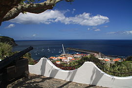
Lajes das Flores
| Lajes das Flores | ||||||
|---|---|---|---|---|---|---|
|
||||||
| Basic data | ||||||
| Autonomous Region : | Azores | |||||
| Concelho : | Lajes das Flores | |||||
| Coordinates : | 39 ° 23 ′ N , 31 ° 11 ′ W | |||||
| Residents: | 627 (as of June 30, 2011) | |||||
| Surface: | 18.79 km² (as of January 1, 2010) | |||||
| Population density : | 33 inhabitants per km² | |||||
| Postal code : | 9960-xxx | |||||
| Lajes das Flores district | ||||||
|
||||||
| Residents: | 1504 (as of June 30, 2011) | |||||
| Surface: | 70.04 km² (as of January 1, 2010) | |||||
| Population density : | 21 inhabitants per km² | |||||
| Number of municipalities : | 7th | |||||
| administration | ||||||
| Administration address: | Câmara Municipal de Lajes das Flores Av. Peixoto Pimentel 9960-431 Lajes das Flores |
|||||
| Website: | www.cmlajesdasflores.pt | |||||
Lajes das Flores ( [ ˈlaʒɨʒ ðɐʃ ˈfloɾɨʃ ] ) is a Portuguese vila (small town) on the island of Flores , which belongs to the western Azores . It is the administrative center of the district of the same name.
geography
Lajes das Flores is the southernmost town on the island.
history
Lajes was built at the beginning of the 16th century and is one of the oldest settlements on Flores.
Attractions
The main church Igreja Matriz Nossa Senhora do Rosário was built between 1763 and 1783. It received its current form, with the tiled facade facing the sea, in the 19th century.
There is a small museum on the history of whaling near the port .
The lighthouse on the Ponta das Lajes , put into operation in 1910, has a range of 26 nautical miles .
Economy and Infrastructure
economy
The whaling era ended in 1981. Milk processing has also not taken place since the 1980s. The port was expanded until 1994 and is now the most important cargo handling point on the island. Tourism plays a relatively minor role. After all, there is a small sandy beach on Lajes, the only settlement on Flores.
traffic
Lajes is located directly on the main road R 1-2, which leads north via the island's capital Santa Cruz to Ponta Delgada . To the west it connects Lajes with Lajedo and Mosteiro . The city's port is the largest on Flores. From here, the Atlanticoline SA ferry goes to Vila do Corvo on the neighboring island of Corvo 10 to 12 times a week all year round . In the summer months of July and August there is a weekly ferry to Horta ( Faial ), São Roque ( Pico ) and Velas ( São Jorge ).
education
In Lajes das Flores there is a primary school, a secondary school and a high school.
Lajes das Flores district
Santa Cruz das Flores County occupies the southern part of Flores. It borders in the north on the Santa Cruz das Flores district; in the other cardinal directions to the Atlantic . The district is divided into seven freguesias (parishes):
| local community | Population (2011) |
Area km² |
Density of population / km² |
LAU code |
|---|---|---|---|---|
| Fajã Grande | 202 | 12.97 | 16 | 480101 |
| Fajazinha | 76 | 6.16 | 12 | 480102 |
| Fazenda | 257 | 9.47 | 27 | 480103 |
| Lajedo | 93 | 6.79 | 14th | 480104 |
| Lajes das Flores | 627 | 18.79 | 33 | 480105 |
| Lomba | 206 | 9.87 | 21st | 480106 |
| Mosteiro | 43 | 5.99 | 7th | 480107 |
| Lajes das Flores district | 1,504 | 70.04 | 21st | 4801 |
The population has steadily decreased since 1849:
| Number of inhabitants in the Lajes das Flores district | |||||||||
|---|---|---|---|---|---|---|---|---|---|
| year | 1849 | 1900 | 1930 | 1960 | 1981 | 1991 | 2001 | 2004 | 2011 |
| Residents | 5982 | 4498 | 3508 | 3376 | 1896 | 1701 | 1502 | 1491 | 1503 |
Individual evidence
- ↑ www.ine.pt - indicator resident population by place of residence and sex; Decennial in the database of the Instituto Nacional de Estatística
- ↑ a b Overview of code assignments from Freguesias on epp.eurostat.ec.europa.eu
- ↑ www.ine.pt - indicator resident population by place of residence and sex; Decennial in the database of the Instituto Nacional de Estatística
Web links
- Lajes das Flores - village-level town in the Azores Online


