
Bad Haring
|
Bad Haring
|
||
|---|---|---|
| coat of arms | Austria map | |
 |
|
|
| Basic data | ||
| Country: | Austria | |
| State : | Tyrol | |
| Political District : | Kufstein | |
| License plate : | KU | |
| Surface: | 9.28 km² | |
| Coordinates : | 47 ° 31 ' N , 12 ° 7' E | |
| Height : | 650 m above sea level A. | |
| Residents : | 2,846 (January 1, 2020) | |
| Postal code : | 6323 | |
| Area code : | 05332 | |
| Community code : | 7 05 03 | |
| NUTS region | AT335 | |
| Address of the municipal administration: |
Obere Dorfstrasse 7 6323 Bad Häring |
|
| Website: | ||
| politics | ||
| Mayor : | Hermann Ritzer ( SPÖ ) | |
|
Municipal Council : (2016) (15 members) |
||
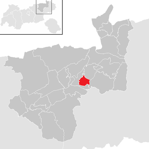
| Location of Bad Häring in the Kufstein district | ||
  |
||
 Town center from the north |
||
| Source: Municipal data from Statistics Austria | ||

Bad Häring is a municipality with 2846 inhabitants (as of January 1, 2020) in the Kufstein district in Tyrol . The community is located in the judicial district of Kufstein .
geography
Bad Häring is located between Wörgl and Kufstein , on a high plateau above the Inn Valley at the foot of the Pölven . The center of the former miners' village is surrounded by several hamlets .
Community structure
|
structure
|
||||||
|
Legend for the breakdown table
|
Neighboring communities
| Schwoich | ||
| Kirchbichl |
.svg)
|
Söll |
history
Numerous magnificent farms bear witness to the agrarian tradition. From the second half of the 18th century until 1954, brown coal was mined. Since 1854, marl and limestone have been extracted for cement production in the Pölven quarries .
In 1951, a strong sulfur spring was found that promoted health tourism . Above all, diseases and complaints of the musculoskeletal system and rheumatic diseases of the joints and vessels as well as damage to the spine are treated. Häring has been nicknamed “Bad” since 1965.
Bad Häring has been the first Tyrolean "spa resort " (not a climatic health resort ) since 1996 . With the decision of the office of the Tyrolean provincial government, the municipality of Bad Häring was recognized as a spa by the Tyrolean provincial government. The name of the health resort was determined to be “Bäderkurort (sulfur therapeutic bath)”. In addition to the baths, a cold therapy chamber is also operated.
Population development
|
1869 to 1910
|
1923 to 1961
|
1971 to 2013
|
Culture and sights
- The parish church of St. Johann Baptist was first mentioned in a document in 1397, is essentially late Gothic and was converted to Baroque style in 1732.
- The Antonius Chapel dates from 1708.
Economy and Infrastructure
Tourism in the two-season tourist destination is of prime economic importance.
The Häring Rehabilitation Center of the General Accident Insurance Fund was opened in 1973 and renovated and rebuilt between 2005 and 2011.
politics
mayor
- since 2003 Hermann Ritzer (SPÖ)
The municipality is a member of the Tyrol Climate Alliance and part of the Kufsteinerland Tourist Association .
Personalities
Sons and daughters of the church
- Franz Lenhart (1898–1992), commercial artist and painter
- Josef Lenzi (1924–1993), politician ( SPÖ )
- Vinzenz Baldemair (1940–2012), provost of Mattsee Abbey 1996–2012
- Gebhard Bucher (1954–2013), restaurateur
photos

Antoniuskapelle, with Scheffauer and Zettenkaiser
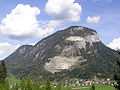
Large and in the background small Pölven , seen from Bad Häring, May 2005
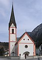
Parish church

Altar in the parish church


Web links
- 70503 - Bad Häring. Community data, Statistics Austria .
- https://www.tirol.gv.at/gemeinden/gemeinde/70503/
- Bad Häring , in the history database ofthe association "fontes historiae - sources of history"
Individual evidence
- ↑ Statistics Austria - Population at the beginning of 2002–2020 by municipalities (area status 01/01/2020)
- ↑ Bad Häring on oesterreich-info.at accessed on May 31, 2010
- ↑ Statistics Austria , accessed on December 22, 2013
Alpbach | Angath | Angerberg | Bad Haring | Brandenberg | Breitenbach am Inn | Brixlegg | Ebbs | Ellmau | Erl | Kirchbichl | Kramsach | Kufstein | Kundl | Langkampfen | Mariastein | Munster | Niederndorf | Niederndorferberg | Radfeld | Rattenberg | Reith im Alpbachtal | Rettenschöss | Scheffau am Wilden Kaiser | Schwoich | Söll | Thiersee | Walchsee | Wildschönau | Worgl
Bad Haring | Ebbs | Erl | Kufstein | Langkampfen | Niederndorf | Niederndorferberg | Schwoich | Thiersee