Vila do Corvo
| Vila do Corvo | ||||||
|---|---|---|---|---|---|---|
|
||||||
| Basic data | ||||||
| Autonomous Region : | Azores | |||||
| Concelho : | Corvo | |||||
| Coordinates : | 39 ° 40 ′ N , 31 ° 7 ′ W | |||||
| Residents: | 430 (as of June 30, 2011) | |||||
| Surface: | 17.11 km² (as of January 1, 2010) | |||||
| Population density : | 25 inhabitants per km² | |||||
| Postal code : | 9980-xxx | |||||
Vila do Corvo is a city on the Azores island of Corvo and the administrative center of the Corvo County . With 430 inhabitants (as of June 30, 2011) it is the second smallest city in Europe after Arnis in Germany.
geography
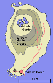
Vila do Corvo is located at the foot of the volcanic crater Caldeirão in the south of Corvo on an old lava flow . It is the only town on the island.
history
Vila do Corvo was built in the 16th century after earlier attempts to colonize the island of Corvo, which was probably discovered in 1452 by the navigator Diogo de Teive , had failed. In the 17th and 18th centuries, the place was considered a haven for pirates . On July 21, 1832, Vila do Corvo was granted city rights by the Portuguese King Peter IV . Electricity was only available on the island in 1963. In 1973 it was connected to the telephone network.
Attractions
The single-nave church Igreja de Nossa Senhora dos Milagres was built from 1789 to 1795. The Holy Spirit Chapel, Império do Espírito Santo da Vila do Corvo, dates from 1871, as indicated by an inscription on the gable. At the Ponta Negra there are three traditional windmills next to the lighthouse .
Economy and Infrastructure
economy
The most important industry is the livestock industry . There are around 1000 cattle on the island. In addition, fishing is carried out.
traffic
Vila do Corvo has three ports, of which only the Porto da Casa is still in use. The Atlanticoline SA ferry that goes to Corvo from Lajes das Flores all year round also docks here. The two other ports are only used for bathing.
Since 1993 the city has an airport with an 850 m long runway. It is served several times a week by the Azorean airline SATA from Santa Cruz das Flores and Horta ( Faial ).
education
There is a primary school in the city.
gallery
Individual evidence
- ↑ www.ine.pt - indicator resident population by place of residence and sex; Decennial in the database of the Instituto Nacional de Estatística
- ↑ Overview of code assignments from Freguesias on epp.eurostat.ec.europa.eu
Web links
- Vila Nova de Corvo - Europe's smallest town in the Azores Online


