
Horta (Portugal)
| Horta | ||||||
|---|---|---|---|---|---|---|
|
||||||
| Basic data | ||||||
| Autonomous Region : | Azores | |||||
| Concelho : | Horta | |||||
| Coordinates : | 38 ° 32 ′ N , 28 ° 38 ′ W | |||||
| Residents: | 2418 (as of June 30, 2011) | |||||
| Surface: | 3.79 km² (as of January 1, 2010) | |||||
| Population density : | 638 inhabitants per km² | |||||
| Horta district | ||||||
|
||||||
| Residents: | 14,994 (as of June 30, 2011) | |||||
| Surface: | 173.04 km² (as of January 1, 2010) | |||||
| Population density : | 87 inhabitants per km² | |||||
| Number of municipalities : | 13 | |||||
| administration | ||||||
| Administration address: | Câmara Municipal de Horta Largo Duque d'Ávila e Bolama Apartado 48 9900-997 Horta |
|||||
| President of the Câmara Municipal: | João Fernando Brum de Azevedo e Castro ( PS ) | |||||
| Website: | www.cmhorta.pt | |||||


Horta ( [ ˈɔɾtɐ ] ) is a Portuguese city ( Cidade ) on the southeast bank of the island of Faial, which belongs to the Azores . Horta has 2418 inhabitants (as of June 30, 2011) and is the administrative seat of the district of the same name ( concelho ), which includes the entire island. The license plate is H .
Horta is the seat of the Assembleia Legislativa da Região Autónoma dos Açores , the regional parliament of the Autonomous Region of Azores.
With the Peter Café Sport there is one of the most famous cafes in the world, an institution especially for sailors. The marina of Horta is an important meeting point for circumnavigators , who leave their colorful memories here on the quay wall, one of the most famous sights. Cruise ships also stop here regularly.

climate
| Horta | ||||||||||||||||||||||||||||||||||||||||||||||||
|---|---|---|---|---|---|---|---|---|---|---|---|---|---|---|---|---|---|---|---|---|---|---|---|---|---|---|---|---|---|---|---|---|---|---|---|---|---|---|---|---|---|---|---|---|---|---|---|---|
| Climate diagram | ||||||||||||||||||||||||||||||||||||||||||||||||
| ||||||||||||||||||||||||||||||||||||||||||||||||
|
Average monthly temperatures and rainfall for Horta
Source: wetterkontor.de
|
|||||||||||||||||||||||||||||||||||||||||||||||||||||||||||||||||||||||||||||||||||||||||||||||||||||||||||||||||||||||||||||||||||||||||||||||||||||||||||||||||||||
history

Map of the pirate Earl of Cumberland by Horta (1589)
|
After the rediscovery in 1427 and the subsequent seizure of the uninhabited Azores by the Portuguese in 1439 , the island of Faial was also settled. From 1466, the Flemish Josse van Huerter received permission to establish localities here. In 1498 King Manuel I granted the resulting port of Horta the city rights of a vila , which means "small town". Most of the inhabitants settled a little further inland in the area of today's municipality of Flamengos, as this area was not visible from the sea and was less likely to suffer from pirate attacks. For example, in 1597, Horta was attacked, pillaged, and looted by Sir Walter Raleigh , with all of the city's churches and monasteries being set on fire.
In the course of the 17th century, Horta gained some importance in the American trade, while before only Angra do Heroísmo was of greater importance. The cultivation of oranges, introduced at the end of the 18th century and their export, especially to the USA, increased economic activity until rampant pest infestation ended the cultivation of the fruit in the Azores in the mid-19th century. A little later, Horta gained importance again in connection with the laying of transcontinental submarine cables .
After the elevation to the status of town ( Cidade ) in 1833, the establishment of public sidewalks from 1858, area-wide public lighting from 1869, and the construction of the new port from 1876 were signs of progressive development. The whaling is an economic factor especially early 20th century, is set professional hunting whales in the Azores to the 1984th The last time a whale was shot was in 1987. As a stopover for transcontinental shipping and especially for sailors, Horta is still important today. In 1976, Horta became the seat of the Parliament of the Azores Autonomous Region.
administration
circle
The district ( concelho ) of Horta covers the entire island of Faial. It is made up of 13 parishes ( freguesias ):


| local community | Population (2011) |
Area km² |
Density of population / km² |
LAU code |
|---|---|---|---|---|
| Angústias | 2,418 | 3.79 | 638 | 470106 |
| Capelo | 486 | 26.64 | 18th | 470101 |
| Castelo Branco | 1,309 | 23.91 | 55 | 470102 |
| Cedros | 907 | 24.54 | 37 | 470103 |
| Conceição | 1,138 | 3.08 | 369 | 470107 |
| Feteira | 1,899 | 14.46 | 131 | 470104 |
| Flamengos | 1,604 | 14.62 | 110 | 470105 |
| Matrix | 2,562 | 1.81 | 1,417 | 470108 |
| Pedro Miguel | 759 | 14.48 | 52 | 470109 |
| Praia do Almox tariffs | 834 | 9.20 | 91 | 470110 |
| Praia do Norte | 250 | 13.85 | 18th | 470111 |
| Ribeirinha | 427 | 12.26 | 35 | 470112 |
| Salão | 401 | 10.40 | 39 | 470113 |
| Horta district | 14,994 | 173.04 | 87 | 4701 |
Population development
| Population in the district of Horta (1849–2011) | |||||||||
| year | 1849 | 1900 | 1930 | 1960 | 1981 | 1991 | 2001 | 2004 | 2011 |
|---|---|---|---|---|---|---|---|---|---|
| Residents | 24,763 | 22,075 | 21,510 | 20,281 | 15,489 | 14,920 | 15,063 | 15,224 | 14,994 |
In the middle of the 20th century, some strong waves of emigration began, especially to the USA, but also to Brazil and Venezuela. In addition, the low birth rate, as in all of Portugal, has not caused the population to rise again since then.
Municipal holiday
- June 24th
Town twinning
-
 New Bedford , United States (since 1993)
 -
Fremont , United States (since 1993)
-
 Santa Cruz on Madeira , Portugal (since 1993)
architecture
Today's Praça da República is the center of the oldest part of the city, which was built in the 15th century and is called "Vila Velha". It is bounded by the small river Ribeira da Conceição, the northern part of the coastal road Avenida Marginal, the Largo do Bispo D. Alexandre and Rua José Fialho. After the 1926 earthquake that destroyed half of Horta's buildings, many buildings were rebuilt in the Art Deco style, e.g. B. the fire station on the north side of the square. The market hall ( Mercado municipal ) on the south side of the square, built in 1841 from stones from the broken parish church Igreja Nossa Senhora da Conceição , was renovated in 1998. In the nearby Rua Serpa Pinto, there is a basalt house (No. 26) from the time the city was founded. The Teatro Faialense theater was built in 1916 in Art Deco style to replace a previous building from 1856, which was the first theater in the entire Azores. There are other Art Deco buildings on Rua Conselheiro Medeiros. At the Jardim Florêncio Terra park there is the Torre do Relógio clock tower, built at the beginning of the 18th century and severely damaged in the 1998 earthquake , the last remnant of the Igreja Nossa Senhora da Conceição church , the original parish church of the city, which was demolished in 1841 due to dilapidation . Today's Igreja Nossa Senhora da Conceição on the bank of the small river Ribeira da Conceição in the north of the oldest part of the city was built in the 15th century, but was set on fire in 1597 when Sir Walter Raleigh attacked Horta and burned down completely. After it was rebuilt in 1607, it was enlarged considerably in 1749 and converted into a three-aisled church building. It was badly damaged in the earthquake of 1926 and rebuilt in its present form in 1941. The church also suffered considerable damage in the 1998 earthquake, after which it was reopened in May 2002.
The construction of today's parish church Igreja do Santíssimo Salvador , a single-nave church with three side chapels, began in 1680 in the Baroque style . The Jesuit College was built next to it in 1719, and it initially served exclusively as a Jesuit monastery church. After the city's original parish church, the Igreja Nossa Senhora da Conceição, became dilapidated, the church was elevated to the parish church of Hortas in 1825. It was badly damaged in the 1926 earthquake and restored in the early 1990s, but it survived the 1998 earthquake almost unscathed. The buildings of the adjoining former Jesuit college now house the city administration of Horta.
The Santa Cruz Fortress was built in 1597 to protect the city from pirate attacks, but it fell into disrepair after 1640 and was gradually renovated from 1847 onwards. In Rua José Azevedo there is the small chapel of the Holy Spirit, Império do Espírito da Infância, with the year 1918 visible on the outside.
The oldest chapel of the Holy Spirit in the Azores is in Horta: the Império dos Nobres , built in the Baroque style to commemorate the volcanic eruption of 1672 , was completed in 1759.
Parks and green spaces


The densely built-up inner city of Horta is loosened up by several green spaces, of which the Jardim Florêncio Terra, laid out in 1857, is one of the oldest. Originally the park, in which several dragon trees were planted, was only called "Jardim Público", which means "Public Park". In 1964 it was renamed after the writer Florêncio Terra (1858–1941) from Horta. A pond with an artificial island was created in the park. A pavilion was built on it in 1883, which is surrounded by four statues that symbolize the four seasons.
On the Praça da República , which is surrounded by buildings in Art Deco style, a park with araucarias and a pavilion was laid out from 1903 in the romanticizing style of the 19th century . Here, too, a pond was created in an irregular shape with bays, in which lava blocks were used.
The area that is now the elongated and green square Praça do Infante was wrested from the sea in the 19th century after the construction of the quay wall. Towards the end of the 19th century, the area called “Largo do Infante” until 1897 was planted, and some of the palm trees that were planted at the time still stand here today. The square got its current size and extent after the earthquake of 1926, in which several buildings around it were destroyed. In 1960 a monument to Heinrich the Navigator was erected on the square, to which the name of the square refers. Several Art Deco-style buildings that arose after the 1926 earthquake also rise from this square.
In 1986 a botanical garden with a size of 8,000 m² was laid out in Flamengos.
Municipal holiday
- June 24th
Town twinning
-
United States : New Bedford (Massachusetts)
-
Portugal : Santa Cruz on Madeira Island
-
United States : Fremont (California)
-
 Brazil : Porto Alegre
traffic
The port of Horta is important, especially for sailors. Ferry traffic to the islands of Pico and São Jorge is operated.
Horta Airport, built in 1971 and redesigned in 2001, has regular connections to other islands and mainland Portugal. International charter traffic is also operated seasonally.
In addition to the individual rental car solution, there is also public transport on the island . In the urban area of Horta, minibus lines and taxis ensure public mobility, while bus lines connect all the larger towns on the island.
The main road EN 1-1a circles the island, the variants EN 1-2a and EN 2-2a branch off into the interior of the island. Side streets connect all other villages.
Educational institutions
The Institute for Oceanography of the University of the Azores, founded in 1976, is located in Horta . The building was built in 1901 and originally served as a hospital.

Parish Church of Igreja do Santíssimo Salvador

Santa Cruz Fortress
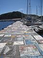
Immortalization of sailors from all over the world on the pier

Torre do Relógio clock tower

Império dos Nobres chapel

Jardim Florêncio Terra park

The Peter Café Sport , internationally known sailing club

Império do Espírito da Infância chapel

Institute of Oceanography of the University of the Azores


sons and daughters of the town
- António Taveira da Neiva Brum da Silveira (1706–1775), Archbishop of Goa
- Alexandre da Sagrada Família (1737-1818), Bishop of Angra
- António José de Ávila (1806–1881), politician, multiple head of government
- António Lourenço da Silveira Macedo (1818–1891), historian and politician
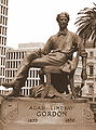
- Adam Lindsay Gordon (1833-1870), Australian national poet
- Manuel Alves Guerra (1834–1910), diplomat and politician
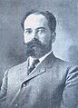
- João José da Graça (1836–1893), lawyer and politician, first newspaper publisher on the island
- Manuel José de Arriaga (1840–1917), lawyer, writer, Rector of the University of Coimbra , first President of the Republic of Portugal
- António Emílio Severino de Avelar (1843–1915), doctor and politician
- José de Arriaga (1844–1921), historian and writer, brother of Manuel de Arriaga
- José Curry da Câmara Cabral (1844–1920), doctor and researcher
- Florêncio Terra (1858–1941), author, publicist and educator
- Manuel Goulart de Medeiros (1861–1947), military and politician, Republican minister
- António Ferreira de Serpa (1865–1939), genealogist and historian
- Eduíno Rocha (1866–1910), surgeon and entrepreneur
- José Osório Goulart (1868–1960), writer
- Feliciano António da Silva Leal (1876–1961), military and colonial administrator in Mozambique
- Augusto Cid (* 1941), caricaturist and illustrator
- Jácome Augusto Paim de Bruges Bettencourt (born 1946), writer
- Teresa Madruga (born 1953), actress
- Ângela Almeida (* 1959), writer and scientist
- Luís Paulo Alves (* 1961), politician
- Iuri Medeiros (* 1994), football player

Alexandre da Sagrada Familia

Antonio José de Ávila

Antonio Lourenço da Silveira de Macedo
Adam Lindsay Gordon, memorial in Melbourne

Manuel José de Arriaga, first President of the Republic of Portugal
Dr. Eduíno Rocha

Jácome Augusto Paim de Bruges Bettencourt


Web links
- Official website
- A detailed portrait of Faials and Horta in the German-language Azores portal
Individual evidence
- ↑ www.ine.pt - indicator resident population by place of residence and sex; Decennial in the database of the Instituto Nacional de Estatística
- ↑ a b Overview of code assignments from Freguesias on epp.eurostat.ec.europa.eu
- ↑ www.ine.pt - indicator resident population by place of residence and sex; Decennial in the database of the Instituto Nacional de Estatística
- ↑ Michael Bussmann: Azoren , p. 345. Erlangen 2016
- ↑ a b Luís Daniel: Faial - Guía do Patrimonio Cultural , p. 120. Lisbon 2003. ISBN 972-96057-1-8 .
- ↑ www.monumentos.pt (under Cronologia ), accessed on September 12, 2013
- ↑ Overview of Horta's town twinning at the Portuguese Verand der Kreisverwaltung (ANMP), accessed on October 21, 2019
- ↑ http://www.azoren-online.com/faial/tipps/sehenswuerdheiten/horta/index.shtml
- ↑ http://www.inventario.iacultura.pt/faial/horta_fichas/71_12_138.html ( page no longer available , search in web archives ) Info: The link was automatically marked as defective. Please check the link according to the instructions and then remove this notice.
- ↑ a b Luís Daniel: Faial - Guía do Patrimonio Cultural , p. 61. Lisbon 2003. ISBN 972-96057-1-8 .
- ↑ Luís Daniel: Faial - Guía do Patrimonio Cultural , p. 119. Lisbon 2003. ISBN 972-96057-1-8 .
- ↑ http://www.inventario.iacultura.pt/faial/horta_fichas/71_11_162.html ( page no longer available , search in web archives ) Info: The link was automatically marked as defective. Please check the link according to the instructions and then remove this notice.
- ↑ Luís Daniel: Faial - Guía do Patrimonio Cultural , p. 113. Lisbon 2003. ISBN 972-96057-1-8 .
- ↑ Stéphan Szeremeta: Açores , p. 198. Paris 2014
- ^ Raquel López Varela: Pico e Faial , p. 56. Rio de Mouro 2007. ISBN 978-989-50-0509-3 .
- ↑ Luís Daniel: Faial - Guía do Patrimonio Cultural , p. 60. Lisbon 2003. ISBN 972-96057-1-8 .
- ↑ Stéphan Szeremeta: Açores , S, 199. Paris 2914
- ↑ www.anmp.pt , accessed on September 12, 2013
- ^ Page about the new partnership on the district website, accessed on September 12, 2013
- ↑ Michael Bussmann: Azoren , p. 362. Erlangen 2016
