Conceição (Horta)
| Conceição | ||||||
|---|---|---|---|---|---|---|
|
||||||
| Basic data | ||||||
| Autonomous Region : | Azores | |||||
| Concelho : | Horta | |||||
| Coordinates : | 38 ° 33 ′ N , 28 ° 37 ′ W | |||||
| Residents: | 1138 (as of June 30, 2011) | |||||
| Surface: | 3.08 km² (as of January 1, 2010) | |||||
| Population density : | 369 inhabitants per km² | |||||
| Postal code : | 9900-081 | |||||
| politics | ||||||
| Mayor : | Gilberto Alvernaz | |||||
| Address of the municipal administration: | Junta de Freguesia de Conceição Lg.Padre José Silvestre Machado 9900-081 Conceição |
|||||
| Website: | www.jf-conceicao.com | |||||
Conceição is a Portuguese parish ( Freguesia ) in the district ( Concelho ) of Horta . 1138 inhabitants live in it (as of June 30, 2011).
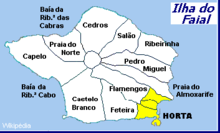
Conceição is one of the three municipalities of Hortas, together with Angústias and Matriz it forms the urban area of the district town of Hortas. Horta County covers the entire island of Faial .
The most important religious buildings in the city of Horta are located in the lower part of the municipality, as is the new terminal for the ferry to the neighboring island of Pico (with tourist information and a large parking lot), Praia da Conceição beach and the adjacent sports and leisure area Parque da Alagoa . The well-known Miradouro de Nossa Senhora da Conceição viewpoint with the characteristic Marian column and the wide view of the bay of Horta is located in the upper, already rural part of the municipality .
Web links
- Website of the Municipal Council of Conceição
- Website of the municipality of Conceição at the district administration of Horta
Individual evidence
- ↑ a b www.ine.pt - indicator resident population by place of residence and sex; Decennial in the database of the Instituto Nacional de Estatística
- ↑ Overview of code assignments from Freguesias on epp.eurostat.ec.europa.eu


