
São Jorge (island)
| São Jorge | |
|---|---|
 |
|
| Waters | Atlantic Ocean |
| Archipelago | Azores |
| Geographical location | 38 ° 38 ′ N , 28 ° 1 ′ W |
 |
|
| length | 53.5 km |
| width | 6.7 km |
| surface | 233.5 km² |
| Highest elevation |
Pico da Esperança 1053 m |
| Residents | 8491 (2016) 36 inhabitants / km² |
| main place | Velas |
 |
|
São Jorge (dt.Saint Georg ) belongs to the central group of the Azores , is 233.5 square kilometers and is 53.5 kilometers long from north-northwest to south-southeast and up to 6.7 kilometers wide between the neighboring islands of Graciosa and Terceira in the north, Faial in the west and Pico in the south. The capital and district town for the west of the island is Velas with around 1900 inhabitants. The eastern part of the island forms the Calheta district . A total of around 8,500 people live on São Jorge.
geography
An average 700 m and in the highest point, the Pico da Esperança, 1,053 m high mountain ridge forms the backbone of the island. São Jorge, like the other islands in the Azores, is of volcanic origin, but there are no caldeiras here. The last major eruption of the Pico da Esperança took place in 1808. The special features of the island include the approximately 75 fajãs , small coastal plains at the foot of the 400 to 700 m high cliffs. They were created by landslides (e.g. the Fajã da Caldeira do Santo Cristo) or lava flows that penetrated to the sea (e.g. Fajã do Ouvidor). Many of these fajãs, which were previously inhabited and used for agriculture, have been abandoned since the severe earthquake of 1980.
history
The island was first mentioned in 1439 and settled by the Flemish Wilhelm van der Haegen . In the 18th century, numerous forts were built on the coast of the island to protect against pirate attacks. On July 9, 1757, the "Mandado de Deus", an earthquake measuring 7.1 to 7.4, shook São Jorge and almost all the other Azores islands and destroyed all settlements in the east from Calheta to Topo . Of about 5000 inhabitants, 1,034 died.
economy
Many people still live from agriculture and livestock farming . Mainly wheat and wine are grown. The island is best known for its good cheese. São Jorge is suitable for a hiking vacation. In 2015 there were seven marked trails. Arrival by plane is possible via São Jorge Airport (SJZ), which opened in 1982, near Velas. In terms of tourism, São Jorge is less developed than most of the other Azores islands. In addition to the main town of Velas, the villages of Manadas and Urzelina are most likely to be visited by tourists. In addition to various churches, several well-preserved or renovated fortresses from the 18th century are worth seeing. B. the Forte da Preguiça in Calheta, the second largest town on the island.

São Jorge, Fajã de São João

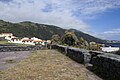
São Jorge, north coast

São Jorge, Fajã da Caldeira de Santo Cristo

São Jorge, view to Pico island
Forte da Preguiça fortress in Calheta

.jpg)

.jpg)

Web links
- The portal of the Azores. Information about the nine islands.
- Administration of the Calheta District
- São Jorge (island) in the Global Volcanism Program of the Smithsonian Institution (English)
- Homepage of the Serviço Regional de Estatística dos Açores (SREA) (engl./port.)
Individual evidence
- ^ Wilhelm Voss-Gerling: Madeira, Azoren , p. 59. Munich 1972
- ↑ José Madeira, António Brum da Silveira: Active tectonics and first paleoseismological results in Faial, Pico and S. Jorge islands (Azores, Portugal) (PDF; 1.49 MB). In: Annals of Geophysics 46, No. 5, 2003, pp. 733-761.
- ↑ São Jorge. Azores trails on trails.visitazores.com, accessed August 20, 2015.
Main islands: Flores |
Corvo |
Faial |
Pico |
São Jorge |
Graciosa |
Terceira |
São Miguel |
Santa Maria
secondary islands: Formigas |
Fradinhos |
Ilhéu de Baixo |
Ilhéu da Baleia |
Ilhéus das Cabras |
Ilhéu das Lagoínhas |
Ilhéu de Maria Vaz |
Ilhéu de São Lourenço |
Ilhéu do Monchique |
Ilhéus dos Mosteiros |
Ilhéu da Praia |
Ilhéu de Vila Franca do Campo |
Ilhéu da Vila do Porto