Urzelina
| Urzelina | ||||||
|---|---|---|---|---|---|---|
|
||||||
| Basic data | ||||||
| Autonomous Region : | Azores | |||||
| Concelho : | Velas | |||||
| Coordinates : | 38 ° 39 ′ N , 28 ° 8 ′ W | |||||
| Residents: | 902 (as of June 30, 2011) | |||||
| Surface: | 13.69 km² (as of January 1, 2010) | |||||
| Population density : | 66 inhabitants per km² | |||||
Urzelina is a Portuguese municipality ( freguesia ) in the Velas district on the Azores island of São Jorge . It has 902 inhabitants (as of June 30, 2011).
The place name is derived from the word urzela , the Portuguese name for the lichen Rocella tinctoria , which grew in large quantities here when the island was settled. A brown dye was obtained from it, which was used in the textile industry in Flanders and which helped the first settlers in this area to modest prosperity.
The place, which was rebuilt after the destruction by an eruption of the Pico da Esperança volcano in 1808, is known today for several striking buildings: During the volcanic eruption on May 1, 1808, which killed 30 people in Urzelina, the lava masses penetrated as far as the From the 17th century village church Antiga Igreja de São Mateus and buried the nave under them, but came to a standstill before the church tower was destroyed. The tower has been preserved to this day and can be climbed. At the entrance to the church, a plaque made of azulejos typical for Portugal and designed in 2008 commemorates the volcanic eruption. The construction of the successor church Igreja de São Mateus , today's parish church of the village, began in 1822.
At the port, a warehouse from the 19th century is worth seeing, which was used to store and cool oranges - they were at times an important export product of the island. Today it serves as a museum. Several villas have been preserved in Urzelina, the construction of which was financed in the 19th century through the export of oranges. In the main street of the village you will find well-preserved, typical rural architecture of the 19th century, various gastronomic establishments and shops to cover daily needs.
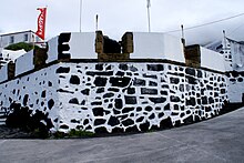
The hexagonal fortress Forte de Urzelina with four loopholes also rises at the port , which - possibly as early as the first half of the 16th century - was built to protect against pirate attacks. Also known as Forte do Castelinho and Forte dos Casteletos, it was renovated in the 1990s. Four cannons can be seen inside.
In the district of Castelete, which is about 2 km southeast of the town center, the baroque chapel Ermida do Senhor Jesus da Boa Morte is noteworthy. It remained unscathed by the volcanic eruption in 1808 and was then used for a long time to store the sacred objects rescued from the destroyed church.
Individual evidence
- ↑ a b www.ine.pt - indicator resident population by place of residence and sex; Decennial in the database of the Instituto Nacional de Estatística
- ↑ Overview of code assignments from Freguesias on epp.eurostat.ec.europa.eu
- ↑ Michael Bussmann: Azoren , p. 115. Erlangen 2016
- ^ Marion Zorn: Azoren , p. 67. Ostfildern 2000
- ↑ Stéphan Szeremeta: Açores , p. 245. Paris 2014
- ↑ Guida das Velas 2009/2010, pág. 11. Nova Grafica, Lda. Dep. Legal, n.º 268828/08.
- ↑ Michael Bussmann: Azoren , p. 455. Erlangen 2016


