Ilhéu de Maria Vaz
| Ilhéu de Maria Vaz | ||
|---|---|---|
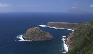
| Ilhéu de Maria Vaz in front of the Punta de Albarnaz with lighthouse . In the background on the right the island of Corvo . | ||
| Waters | Atlantic Ocean | |
| Archipelago | Azores | |
| Geographical location | 39 ° 30 '26 " N , 31 ° 14' 37" W | |
|
|
||
| length | 420 m | |
| width | 310 m | |
| surface | 9 ha | |
| Highest elevation | 161 m | |
| Residents | uninhabited | |
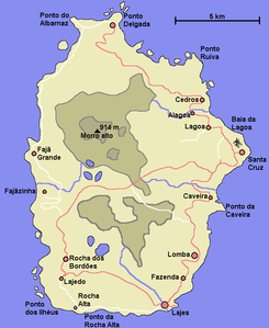
| Map of the island of Flores with Ilhéu de Maria Vaz in the northwest | ||
The Ilhéu de Maria Vaz , also called Ilhéu da Gadelha , is a small island off the northwest coast of the Azores island of Flores . It belongs to the municipality of Ponta Delgada in the Santa Cruz das Flores district .
The volcanic island is located south-southwest of the Punta de Albarnaz about 130 m off the west coast of Flores. It is about 420 m long, oval in shape and rises steeply to 161 m.
The Ilhéu de Maria Vaz is a nature reserve of the IUCN Category I ( Strict Nature Reserve / Wilderness Area ). It is covered in vegetation and frequented by sea birds such as the Mediterranean seagull.
Individual evidence
- ↑ Car and Leisure Map Azores 1: 50,000 , Freytag & Berndt, Vienna 2015. ISBN 978-3-7079-1060-5 .
- ↑ Nature Reserve (Category I - IUCN) on the website of the Government of the Azores, accessed on February 11, 2017 (English).
- ↑ Nature Reserve of Ilhéu de Maria Vaz on the website of the Government of the Azores, accessed on February 11, 2017.


