
Ponta Delgada (Santa Cruz das Flores)
| Ponta Delgada | ||||||
|---|---|---|---|---|---|---|
|
||||||
| Basic data | ||||||
| Autonomous Region : | Azores | |||||
| Concelho : | Santa Cruz das Flores | |||||
| Coordinates : | 39 ° 31 ′ N , 31 ° 12 ′ W | |||||
| Residents: | 359 (as of June 30, 2011) | |||||
| Surface: | 17.65 km² (as of January 1, 2010) | |||||
| Population density : | 20 inhabitants per km² | |||||
| Postal code : | 9970-064 | |||||
| politics | ||||||
| Mayor : | António Avelar Xavier ( PS ) | |||||
| Address of the municipal administration: | Junta de Freguesia de Ponta Delgada Rua da Levada 9970-064 Ponta Delgada |
|||||


Ponta Delgada is a Portuguese municipality ( freguesia ) on the Azores island of Flores . It belongs to the district ( concelho ) of Santa Cruz das Flores and has 359 inhabitants (as of June 30, 2011).
Geography and traffic
The main road R 1-2 begins in Ponta Delgada and leads on the east coast via Santa Cruz to Lajes das Flores . The south-western neighboring community of Fajã Grande can only be reached directly via an old mule track , which is now signposted as a hiking trail (PR 1 FLO).
History and sights
Ponta Delgada was founded in the second half of the 16th century and is one of the three oldest parishes on Flores. The Igreja de São Pedro church in the center of the village was built in 1763 on the remains of an older chapel. Two kilometers west of Ponta Delgada is the westernmost lighthouse in Europe, the Farol do Albarnaz , which was commissioned in 1925 at Cape Ponta do Albarnaz .

View of Ponta Delgada

Igreja de São Pedro church
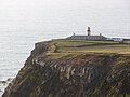
Lighthouse at the Ponta do Albarnaz


Web links
- Ponta Delgada - the northern end of the Azores Online
Individual evidence
- ↑ a b www.ine.pt - indicator resident population by place of residence and sex; Decennial in the database of the Instituto Nacional de Estatística
- ↑ Overview of code assignments from Freguesias on epp.eurostat.ec.europa.eu
