Vila Franca do Campo
| Vila Franca do Campo | ||||||
|---|---|---|---|---|---|---|
|
||||||
| Basic data | ||||||
| Autonomous Region : | Azores | |||||
| Concelho : | Vila Franca do Campo | |||||
| Coordinates : | 37 ° 43 ′ N , 25 ° 26 ′ W | |||||
| Residents: | 11,229 (as of June 30, 2011) | |||||
| Surface: | 77.96 km² (as of January 1, 2010) | |||||
| Population density : | 144 inhabitants per km² | |||||
| Postal code : | 9680 | |||||
| politics | ||||||
| Mayor : | Ricardo Rodrigues | |||||
| Vila Franca do Campo district | ||||||
|
||||||
| Residents: | 11,229 (as of June 30, 2011) | |||||
| Surface: | 77.96 km² (as of January 1, 2010) | |||||
| Population density : | 144 inhabitants per km² | |||||
| Number of municipalities : | 5 | |||||
| administration | ||||||
| Administration address: | Câmara Municipal de Vila Franca do Campo Praça da República 9680-115 Vila Franca do Campo |
|||||
| President of the Câmara Municipal: | António Fernando Raposo Cordeiro ( PS ) | |||||
| Website: | www.cmvfc.pt | |||||
Vila Franca do Campo ( [ ˈvilɐ ˈfɾɐ̃kɐ ðu ˈkɐ̃pu ] ) is a small town ( Vila ) and a district ( Concelho ) on São Miguel , an island in the Azores belonging to Portugal . The city has about 4100 inhabitants. 11,229 people live in the district on an area of 78 km² (as of June 30, 2011), which corresponds to a population density of 144 inhabitants / km².
geography
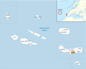
Vila Franca do Campo is located on the south coast of the largest Azores island of São Miguel. In front of the place in the Atlantic Ocean is the small volcanic island of Ilhéu de Vila Franca do Campo , whose crater wall is broken on the north side towards the sea, so that seawater can flow in and sand has been deposited. The result is a natural swimming pool, the depth of which barely exceeds a meter at high tide. During the summer months, boats go from Vila Franca to the Ilheu (the crossing takes about 20 minutes) and bring adults and children there for a day of swimming. Opposite the island is the Praia da Vinha da Areia .
Origin of the place name
Vila is the Portuguese word for "small town" and campo means "plain". The addition franca ("free") refers to the fact that city residents were originally exempt from paying taxes.
history
The place Vila Franca do Campo became the first capital of São Miguel after the discovery of the - until then deserted - Azores island by Portuguese seafarers in the year 1427. However, there are indications that the Phoenicians already knew the Azores in antiquity . Soon after the Portuguese began to settle São Miguel permanently, the town was founded from Povoação . The feudal lord of the island, the founding nobility and the large landowners lived in Vila Franca. The customs authority was located here until 1518 and the place quickly became the most important settlement on the island. On the night of October 21-22, 1522, however, the place was destroyed by a landslide caused by an earthquake . The entire population of around 5000 people was killed. Then the capital was relocated to Ponta Delgada , which has received this status to this day. Vila Franca recovered and is now a flourishing district town.
architecture
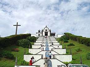
The city is dominated by the chapel Ermida de Nossa Senhora da Paz , built in 1764 , to which a stairway decorated with tiles ( azulejos ) leads. In the city center are the former monastery church Igreja de Santo André from the 17th century, which belonged to a Clarissa monastery that was dissolved in 1832, the baroque Igreja de São Pedro with an altar from 1754 and the three-aisled parish church Igreja de São Miguel Arcanjo from the 16th century. which was rebuilt in the original style after the earthquake of 1522.
administration
circle
Vila Franca do Campo is the seat of a district of the same name ( concelho ). Its neighboring districts are:
| Ribeira Grande | ||
| Lagoa |

|
Povoação |
| Atlantic Ocean |
The urban area of Vila Franca do Campo is formed by the two municipalities of São Miguel and São Pedro. The Vila Franca do Campo district consists of the following six municipalities ( freguesias ):
| local community | Population (2011) |
Area km² |
Density of population / km² |
LAU code |
|---|---|---|---|---|
| Água de Alto | 1,788 | 18.41 | 97 | 420601 |
| Ponta Garça | 3,547 | 29.35 | 121 | 420602 |
| Ribeira das Tainhas | 703 | 9.59 | 73 | 420603 |
| Ribeira Seca | 1.106 | 5.53 | 200 | 420606 |
| São Miguel | 2,659 | 12.60 | 211 | 420604 |
| Sao Pedro | 1,426 | 2.48 | 574 | 420605 |
| Vila Franca do Campo district | 11,229 | 77.96 | 144 | 4206 |
Population development
| Population in the Vila Franca do Campo County 1849–2011 | |||||||||
| year | 1849 | 1900 | 1930 | 1960 | 1981 | 1991 | 2001 | 2004 | 2011 |
|---|---|---|---|---|---|---|---|---|---|
| Residents | 8,398 | 11,190 | 11.204 | 14,596 | 11,866 | 11,050 | 11,150 | 11,039 | 11,229 |
Municipal holiday
- June 24th
Town twinning
sons and daughters of the town
- Bento de Góis (1562–1607), Jesuit missionary, explorer in Asia
- Urbano de Mendonça Dias (1878–1951), writer, journalist, lawyer and educator
- Ernesto Ferreira (1880–1943), Catholic priest, ethnologist and naturalist
- Armando Cortes-Rodrigues (1891–1971), writer, playwright, poet, philologist and ethnologist
- Artur do Canto Resende (1897–1945), surveyor
- José Medeiros (* 1951), musician and composer, actor and director
Web links
- Official website (port.)
- Photos from Vila Franca do Campo (engl./port.)
- Portrait of the place on the German website www.azoren-online.de
Individual evidence
- ↑ a b www.ine.pt - indicator resident population by place of residence and sex; Decennial in the database of the Instituto Nacional de Estatística
- ↑ a b Overview of code assignments from Freguesias on epp.eurostat.ec.europa.eu
- ↑ Stéphan Szeremeta: Açores , p. 111. Paris 2014
- ↑ Tommy Andersson: Geology of Lagoa das Furnas, a crater lake on São Miguel, Azores archipelago (PDF; 2.77 MB). Dissertation, Stockholm University, 2005, p. 6.
- ↑ Stéphan Szeremeta: Açores , p. 113. Paris 2014
- ↑ www.anmp.pt , accessed on September 1, 2013.


