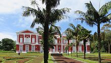
Ponta Delgada
| Ponta Delgada | ||||||
|---|---|---|---|---|---|---|
|
||||||
| Basic data | ||||||
| Autonomous Region : | Azores | |||||
| Concelho : | Ponta Delgada | |||||
| Coordinates : | 37 ° 45 ′ N , 25 ° 40 ′ W | |||||
| Residents: | 68,808 (as of June 30, 2011) | |||||
| Surface: | 232.97 km² (as of January 1, 2010) | |||||
| Population density : | 295 inhabitants per km² | |||||
| Postal code : | 9504-xxx | |||||
| politics | ||||||
| Website: | www.cm-pontadelgada.pt | |||||
| Ponta Delgada district | ||||||
|
||||||
| Residents: | 68,808 (as of June 30, 2011) | |||||
| Surface: | 232.97 km² (as of January 1, 2010) | |||||
| Population density : | 295 inhabitants per km² | |||||
| Number of municipalities : | 24 | |||||
| administration | ||||||
| Administration address: | Câmara Municipal de Ponta Delgada Praça do Município 9504-523 Ponta Delgada |
|||||
| Website: | www.cm-pontadelgada.pt | |||||
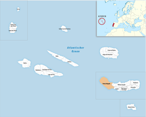
Ponta Delgada ( [ ˈpõtɐ ˌðɛɫˈɣaðɐ ] , German: Narrow tip ) is the capital of the Azores on the island of São Miguel , but also the administrative district of the same name in the south and west of the island. The three municipalities of Ponta Delgada have a combined population of around 17,800.
Here is the seat of the provincial government and the capital of the University of the Azores, founded in 1976 (Universidade dos Açores). The license plate is A .
history
Ponta Delgada was built in 1499 by the Portuguese King Manuel I established. It was a fishing settlement in today's Calheta district with the Igreja de São Pedro church , which together with the São José settlement still border the city center to the east and west. A small headland in front of Calheta gave Ponta Delgada (= thin / narrow point) its name. The settlement around a monastery with hospital and safe harbor grew rapidly in the years to come and in 1522 it became a refuge for the island administrator Rui II , who moved from Vila Franca do Campo , which was destroyed after an earthquake . As a result, Ponta Delgada was on April 2, 1546 under the rule of King John III. the city rights awarded.
With the seat of the island administration, the importance grew, in 1522 the construction of the Forte de São Brás to protect against pirate attacks began . The resulting increase in population took place in 1673 as a result of a plague epidemic . With the establishment of orange plantations at the end of the 18th century, the prosperity of the city grew through the influx of foreign merchants and Jewish families from 1818, including the Bensaude family . Numerous stately houses, new streets, a cemetery, as well as gardens and parks in the English style still bear witness to this time. The roofs of several historic buildings from the 18th and 19th centuries are crowned with small square structures that were used by the plantation owners as lookouts. Servants had to keep an eye out for incoming cargo ships so that freshly harvested oranges could be made available for export to mainland Europe and England.
Pope Paul III had already raised Angra do Heroísmo to the seat of the diocese of Angra in 1534 and thus to the most important city of the Azores Islands. The high tax burden and dependence on the bishopric slowed down the further development of Ponta Delgada. In 1821 there was a successful revolt with the participation of the soldiers stationed on São Miguel, which led to the island's independence.
In 1828, the construction of the sewer system under the Vice Admiral of the Portuguese Navy and last captain general of the captaincy of the Azores Henrique da Fonseca de Sousa Prego (1768-1847) began. The first street lighting , still operated with fish oil , was put into service in 1839 and electrified in 1904. In 1901 the first car was introduced on São Miguel. After fierce demands from the orange barons, the port was expanded , but before construction work began on the new port basin in 1861, the orange trees had already fallen victim to an insidious fungus. Before, merchant ships could only anchor in the harbor basin and the orange crates had to be transported out to the schooners in small boats . The new port contributed significantly to the further economic development of Ponta Delgada. It has been expanded several times over the decades: In 1947, the promenade was fortified and the first row of houses, which was regularly flooded during storms, was set back by around 40 meters.
Since 1975 Ponta Delgada has been the seat of the regional government of the Azores. The following year the University of the Azores was founded here.
location
The city center essentially consists of the central part Sao Sebastião around the church of the same name and the area of the parish São Pedro in the east of the center and São José in the southwest. Further around the city lie the two places Fajã de Baixo , the "low place" and Fajã de Cima , the "higher place".
Fajã de Baixo is known for the pineapple grown there , Fajã de Cima for its exuberant festivities and the cream cheese made from a mixture of goat and cow milk . Both places are commuter locations and many of the residents work in the center of the city. Every year in May, the "Dia do Santo Cristo", the feast of the Holy Christ , is celebrated with lavishly decorated streets lined with flowers.
port
The port of Ponta Delgada has always played a central role due to its island location and has been repeatedly expanded, enlarged and fortified since the city was founded. The two port basins with the entrance on the east side have a size of approximately 550 m × 1200 m, the protective pier has a length of 1500 m. The minimum fairway depth is 9.4 m, the anchorage depth 14.0 m and the depth of the cargo pier 12.5 m, the average tidal range is 2.0 m. The freight traffic of containers, vehicles and general cargo between the islands for the Azores is carried out by the company Açores Expresso , which also ensures supplies from the mainland via the port of Leixões with four container ships twice a week . With the most recent expansion, which was completed in 2008 and largely realized with EU funding, the sleeping area has been quadrupled and now offers space for 640 yachts . At the same time, with the Portas do Mar program, a modern cruise terminal was created that offers space for passenger ships and large yachts up to 360 m in length.
The company Atlanicoline started in 2005 with ferry traffic for vehicles and passengers between the islands to the ports of Porto Horta on Faial , Porto São Roque do Pico , Praia on Graciosa , Porto Velas on São Jorge , Villa do Porto on Santa Maria and Ponta Delgada with two ships called lha Azuk and Express Santorini . In 2009 the high-speed ferry was added as "Vikings", currently the ferries are called: Santorin , Arie and Hellenic Wind . Ponta Delgada's marina has held the Blue Flag since 1999. Whale watching tours , which are offered by several small companies and run regularly in the mornings and afternoons, are an attraction of the harbor life . In the harbor there is a sea rescue tug and a small fishing fleet. In the Azores, catching deep-sea fish is very diverse and very different types of fishing gear are used. The most common species caught are tuna (39%), gray bass (30%), bream (16%) and horse mackerel (12%). Most of the fish is caught by vessels less than 12 meters in length.
At the port there was the Ponta Delgada port railway between 1861 and 1973 in the Brunel wide -gauge track of seven feet (2134 mm).
panorama
climate
| Ponta Delgada | ||||||||||||||||||||||||||||||||||||||||||||||||
|---|---|---|---|---|---|---|---|---|---|---|---|---|---|---|---|---|---|---|---|---|---|---|---|---|---|---|---|---|---|---|---|---|---|---|---|---|---|---|---|---|---|---|---|---|---|---|---|---|
| Climate diagram | ||||||||||||||||||||||||||||||||||||||||||||||||
| ||||||||||||||||||||||||||||||||||||||||||||||||
|
Average monthly temperatures and rainfall for Ponta Delgada
Source: Instituto de Meteorologia
|
|||||||||||||||||||||||||||||||||||||||||||||||||||||||||||||||||||||||||||||||||||||||||||||||||||||||||
Communities
| local community | Population (2011) |
Area km² |
Density of population / km² |
LAU code |
|---|---|---|---|---|
| Ajuda da Bretanha | 661 | 7.09 | 93 | 420323 |
| Arrifes | 7,086 | 25.37 | 279 | 420301 |
| Candelaria | 1,079 | 8.63 | 125 | 420303 |
| Capelas | 4,080 | 16.85 | 242 | 420304 |
| Covoada | 1,341 | 9.03 | 148 | 420305 |
| Fajã de Baixo | 5,050 | 4.06 | 1,243 | 420306 |
| Fajã de Cima | 3,438 | 11.89 | 289 | 420307 |
| Fenais da Luz | 2,009 | 7.69 | 261 | 420308 |
| Feteiras | 1,571 | 23.53 | 67 | 420309 |
| Ginetes | 1,378 | 12.14 | 114 | 420310 |
| Livramento | 4,062 | 5.59 | 727 | 420317 |
| Mosteiros | 1,123 | 8.95 | 125 | 420311 |
| Pilar da Bretanha | 624 | 6.07 | 103 | 420324 |
| Relva | 3,006 | 12.07 | 249 | 420315 |
| Remédios | 931 | 5.59 | 166 | 420316 |
| Santa Bárbara | 855 | 8.72 | 98 | 420319 |
| Santa Clara | 2,971 | 2.24 | 1,325 | 420325 |
| Santo António | 1,829 | 11.75 | 156 | 420320 |
| São José | 5,934 | 1.66 | 3,579 | 420313 |
| Sao Pedro | 7,742 | 2.89 | 2,674 | 420314 |
| Sao Roque | 4,932 | 7.21 | 684 | 420318 |
| São Sebastião | 3,953 | 3.34 | 1,185 | 420312 |
| Sao Vicente Ferreira | 2,361 | 11.42 | 207 | 420321 |
| Sete Cidades | 793 | 19.19 | 41 | 420322 |
| Ponta Delgada district | 68,808 | 232.97 | 295 | 4203 |
Attractions
- Largo de Goncalo Velho Cabral is the central square of Ponta Delgada and was named after the first island administrator, Gonçalo Velho Cabral, to whom a memorial is also dedicated here. The buildings with the arcades, such as the bank on the east side of the square, were previously located directly on the sea and were used in the 18th and 19th centuries for loading and unloading merchandise. Before the bank was fortified with a mole, the three-arched city gate Portas da Cidade from 1783 stood as a gate to the city directly at the small harbor. It is now the symbol of Ponta Delgada. The square forms the optical center of the long bay of Ponta Delgada, along the banks of which the long, wide Avenida Infante Dom Henrique , in this form from 1952, runs. Not only is it the city's main thoroughfare, but most banks and offices can be found along this street. On the south side, directly along the sea, is a promenade with small cafés at the former fishing port of Cais da Sardinha , the outdoor pool Piscina , the marina Marina .
- The town hall of Càmara Minicipal is a typical Azorean baroque building from the first half of the 18th century. Erected as the residence of a noble family, it dominates the narrow, elongated Praça da Republica with its fountain. At the beginning of the 20th century, the administration moved into the building, the entrance of which is below the balconies crowned with the city arms. Exhibitions by local artists are held regularly on the ground floor, which is furnished with plenty of valuable antique furniture. In the tower of the town hall, built in 1724, with a wonderful all-round view of the city, hangs a bell from King Dom Joao III. from the 16th century. It is the oldest bell in the Azores. In front of the building is the statue of the patron saint, São Miguel .
- The Praça 5 de Outubro , formerly: Campo de São Francisco is almost square and has an Asian-looking pavilion in the middle. In the square is an ancient Australian metrosidero (ironwood tree) that was planted in 1870. In the summer evenings and at countless festivals, the city's population gathers on the square.
- The Igreja de São José on the west side of Praça 5 de Outubro once belonged to the Franciscan monastery Convento de nossa Senhora da Conceição . In sixty years of construction in the 16th century, the largest church building in the Azores was created, the three-aisled front with a new facade, the portico and three rows of windows, designed in the early 18th century. Five bas-reliefs carved in limestone with scenes from the life of St. Francis and a niche with a basalt statue of the patron saint adorn the front. The interior is dominated by four splendid side altars , the choir is decorated with valuable azulejos . The Igreja de São José also includes the Nossa Senhora da Dores chapel on the left, which was added later , a prime example of baroque architecture in the Azores. Until 1864, the chapel was the starting point of processions in which the faithful whipped themselves with whips in order to obtain forgiveness of sins.
- The construction of the narrow monastery church Igreja da Nossa Senhora da Esperança , also Igreja de Santo Cristo , on the north side of Praça 5 de Outubro was initiated by the then governor Rui Goncalves da Camara and in 1541 together with the nunnery Convento da Esperança , which is still there thirteen nuns live, completed. The decisive element is the Christ statue of Senhor Santo Cristo dos Milagres in the lower choir, which is separated by an iron grille from the upper choir with its richly decorated high altar, created by Diego Bernardes in the 18th century. The nun Teresa da Anunciadas (* 1658- † 1738), whose bones are kept in a precious chest in the lower choir, guarded the bust until her death in 1737 and contributed significantly to the spread of the cult. The subject is taken up by the writer Ralph Roger Glöckler in his Azores trilogy , the relationship between nun and portrait is represented here in a kind of delirium of death in which the time levels are connected.
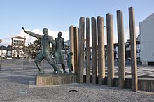
- The Monumento ao Emigrante by Alavaro Raposo Franga from 1999 stands on the south side of Praça 5 de Outubro . The memorial consists of concrete steles, stone mosaics and three life-size bronze figures and represents an emigrant family looking to a better future. The father of the family hopefully points to the West - to America. Around this monument the black and white cobblestone paving of the city comes to its climax. Many squares and sidewalks are artistically paved with various imaginative patterns and figures using the island's own basalt and granite stone from mainland Portugal.
- The Forte de São Brás is located on the south side of Praça 5 de Outubro at the west end of the port. The polygonal building, which was designed by the Italian Tommaso Benedetto , was built in 1552 to protect the islanders from regular pirate attacks right next to the anchorage at that time and was rebuilt several times in the course of the 19th century. The Portuguese Navy operates a museum there with exhibits from the last centuries. The monument in front of the bastion with cannons from 1874 commemorates the victims of the First World War . The bust in front of the walls represents the former president Teófilo Braga .
- Between Largo de Goncalo Velho Cabral in the east and Praça 5 de Outubro in the west, you pass the old post office building and reach Praça Vasco da Gama with a remarkable Venus fountain. Along the Avenida Infante Dom Henrique you come to the Alfândega customs house, the Ministry of Defense is housed in a corner building with the round tower.
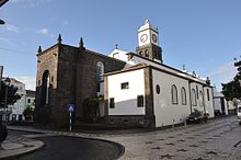
- The Igreja Matriz de São Sebastião, the main church of Ponta Delgada, is located right in the city center . The Matriz was initially built as a small pilgrimage chapel for São Sebastião , the island's first patron saint, between 1531 and 1547 as a thank you for helping against the plague that raged on the island from 1523 to 1531. From the outside it impresses with the portals in the Manueline and Baroque style, which were added to the original late Gothic style in the 18th century with redesigns and extensions. The Manueline main portal was supplemented by two side portals, a rose window and four windows decorated with colorful figures of saints were installed. The interior is dominated by carvings made from cedar and other rare types of wood such as guaiac wood from Brazilian colonies, and wooden furniture made from rosewood dates from the 17th century. The sacristy has beautiful tile pictures and a large collection of gold-embroidered paraments made in England from the 16th century. The church tower of the Matriz is the only church in town to have a clock.
- The Museu Carlos Machado, the most important museum in the Azores, was founded in 1876 by the rector of the Liceu Nacional in Ponta Delgada, Carlos Maria Gomes Machado , and has been housed in the former Convento de Santo André from the 16th century since 1930 . With a variety of exhibits, the ancient Azorean life is presented in categories of agriculture, customs, fishing, history, geology, handicrafts, fishing, natural and cultural history and toys. The exhibition of local artists complements the portfolio of paintings from the 15th to 20th centuries and sculptures, including works by Canto da Maia , who created goldsmiths and ivory images of saints.
- The church Igreja de São Pedro was built in the first half of the 18th century in Baroque style on the foundations of a 15th century chapel that was destroyed in an earthquake and is the parish church of the district of the same name. In the single-nave, octagonal church interior, the high altar with its gilded wood carvings is remarkable, as is the portrait of Nossa Senhora das Dores , which is considered the most beautiful baroque sculpture in the Azores. The painting Pentecostés ( Pentecost ) by Pedro Alexandrino de Carvalho dates from the 18th century .
- The Igreja de Todos-os-Santos , better known as Igreja do Colégio dos Jesuítas with a magnificent baroque, richly decorated facade is the most beautiful architectural building in the city in the Baroque style. The foundation stone was laid on All Saints' Day , November 1st, 1592, in the presence of the governor Gonçalo Vaz Coutinho . Between 1643 and 1646 the new altarpiece was installed in the choir. The new facade was completed in 1666. It was rebuilt several times and was most recently completely renovated from 1997 until it reopened in 2005. The church was supposed to become part of the Jesuit College, but the Jesuits were driven out under Marques de Pombal . Next to it is the library and the city archive with many historical documents from the city's history.
- The Jardim Antero de Quental garden is dedicated to the poet Antero de Quental , who was born in Ponta Delgada and went down as a leading figure in Portuguese literary history. As a member of the Geração de 70 poets' circle , he promoted the spread of socialism in Portugal, fell into depression for lack of recognition and ended his life in Ponta Delgada by suicide on September 11, 1891 . He shot himself with two pistol shots on Praça 5 de Outubro , but did not die immediately, but only two hours later in the hospital.
- The Jardim António Borges city park is very imaginative and rich in detail. In the 19th century it was originally laid out as a private garden with plants from all over the world by the first and most successful pineapple grower Borges.
- The government of the Autonomous Region of the Azores resides in the Palácio de Sant'Ana , alternately in addition to two other official seats in Horta and Santa Maria . In the rooms of the three-winged complex, which is not open to the public, you will find valuable pieces of furniture. Around the palace is the largest botanical complex on the island, the Jardim Jácome Correia , also: Jardim do Palácio de Sant'ana . In 1846, the Correia family commissioned an English architect to design the palace and park. To the east of the palace is the second park, Jardim José do Canto, with the residence of the park founder, the Palacio José do Canto , which has been converted into a hotel . José do Canto was a gardening enthusiast and had the plant laid out in the 19th century on an area of around five hectares with several thousand exotic plants that were supplied from Belgium, Germany, London, Paris and Rio de Janeiro. He also kept a list of plants that he did not want in his park.
- The Gruta do Carvão is a geological formation of volcanic origin, it is located in the northwest of Ponta Delgada. It is a natural monument consisting of four sections: Paim , Secadores de Tabaco , João do Rego and José Bensaúde . It is a formerly 22 km long lava drainage channel from the Complexo Vulcânico dos Picos , an area with around 200 inactive volcanoes. When the bypass was built, today's entrance was exposed. The cave can be entered here in the southern section over 700 meters, in the northern part over a distance of about 550 meters to the west. The cavity has an average height of around two to three meters, in some places more than five meters. In some sections, sand and rubble with an average thickness of about one meter were deposited. The width of the cave is very variable and is sometimes more than ten meters, especially at the intersections of converging canals - in a section of 200 meters there are two overlapping systems. The natural wealth of the Gruta do Carvão is the great diversity of geological features and structures of typical volcanic phenomena. Individual structures indicate that accumulated gases exploded, causing cracks in the walls and ceiling of the cave. A lot of stalactites were formed on the ceilings and walls, they are usually conical in shape and have smooth surfaces. They are the result of the solidification of lava droplets. Or irregular shapes formed, often white / yellowish and extremely fragile.
Town twinning
Sister cities of Ponta Delgada are:
|
|
sons and daughters of the town
- Gaspar Frutuoso (1522–1591), spiritual historian
- José do Canto (1820–1898), agricultural entrepreneur and botanist, important book collector, particularly of Camões works
- Ernesto do Canto (1831–1900), historian, librarian and politician
- Antero de Quental (1842-1891), writer and social reformer
- Teófilo Braga (1843–1924), man of letters and politician, two-time President
- Ernesto Rodolfo Hintze Ribeiro (1849–1907), politician
- Roberto Ivens (1850–1898), officer and Africa explorer
- Alfredo Bensaúde (1856–1941), mineralogist
- Joaquim Bensaúde (1859–1952), engineer and historian
- Maurício Bensaude (1863–1912), opera singer, internationally known baritone
- Raoul Bensaude (1866–1938), important physician in France
- Filomeno da Câmara de Melo Cabral (1873–1934), military, politician and colonial administrator, governor of Portuguese Timor
- Francisco Luís Tavares (1886–1968), entrepreneur, journalist, lawyer and politician
- Ernesto Canto da Maia (1890–1981), modernist sculptor
- Rui Galvão de Carvalho (1903–1991), writer, literary scholar and university lecturer
- Eurico Tomás de Lima (1908–1989), composer and pianist
- Humberto Sousa Medeiros (1915–1983), Archbishop of Boston
- Manuel Eugénio Machado Macedo (1922–2000), surgeon, 1990–1992 President of the World Medical Association
- Natália Correia (1923–1993), writer, intellectual and politician
- Carlos Alberto Medeiros (* 1942), geographer
- José Medeiros Ferreira (* 1942), politician and university professor, Foreign Minister of the first Soares government
- Mota Amaral (* 1943), politician
- Jaime Gama (* 1947), politician, co-founder of the Partido Socialista , multiple minister
- Berta Cabral (* 1952), politician
- José Eduardo Moniz (* 1952), television journalist, producer and manager
- Carlos César (* 1956), journalist and socialist politician
- Rosa Coutinho Cabral (born 1956), director
- João Aguiar Machado (* 1959), economist, since 2014 Director General for Mobility and Transport of the EU
- André Bradford (1970–2019), politician (PS), MEP
- Pauleta (* 1973), football player
- Sofia Ribeiro (* 1976), politician
- Nuno Sociedade (* 1978), football player
Natália Correia, painting by Carlos Botelho
Jaime Gama in Brasília 2008
Web links
- Official website of the city administration (Portuguese)
- Azores-Online (German)
- Photos of Ponta Delgada
Individual evidence
- ↑ a b www.ine.pt - indicator resident population by place of residence and sex; Decennial in the database of the Instituto Nacional de Estatística
- ↑ a b Overview of code assignments from Freguesias on epp.eurostat.ec.europa.eu
- ↑ a b Michael Bussmann, Azoren, Michael Müller Verlag, Erlangen, 5th edition 2013, page 140 ff., ISBN 3-89953-257-0
- ↑ a b Roman Martin on Portal der Azores accessed on October 18, 2016
- ↑ Port information FleetMon accessed on October 19, 2016
- ↑ Information from Açores Expresso, accessed on October 19, 2016
- ↑ Portas do Mar website accessed on October 19, 2016
- ↑ Jesús Iborra Martín, Fisheries in Portugal, European Parliament - Structural and Cohesion Policy Department, Brussels, 2011
- ↑ Broad gauge harbor line. railway-azores.ernstkers.nl, archived from the original on March 23, 2012 ; accessed on September 4, 2018 .
- ↑ Chris Brady: The Broad Gauge Railway of the Azores / Açores. Accessed September 4, 2018 .
- ^ Michael Bussmann, Azoren, Michael Müller Verlag, Erlangen, 5th edition 2013, page 155 ff, ISBN 3-89953-257-0
- ↑ Description of the Portuguese Ministry of Culture accessed on October 17, 2016
- ↑ Description of the Portuguese Ministry of Culture accessed on October 17, 2016
- ^ Website of the Carlos Machado Museum accessed on October 17, 2016
- ^ Website of the Gruta do Carvão, information also guided tour from April 9, 2016, accessed on October 17, 2016
- ↑ Associação Nacional de Municípios Portugueses, Geminações de Cidades e Vilas
