
Madalena (Azores)
| Madalena | ||||||
|---|---|---|---|---|---|---|
|
||||||
| Basic data | ||||||
| Autonomous Region : | Azores | |||||
| Concelho : | Madalena | |||||
| Coordinates : | 38 ° 32 ′ N , 28 ° 32 ′ W | |||||
| Residents: | 2581 (as of June 30, 2011) | |||||
| Surface: | 35.59 km² (as of January 1, 2010) | |||||
| Population density : | 73 inhabitants per km² | |||||
| Madalena district | ||||||
|
||||||
| Residents: | 6049 (as of June 30, 2011) | |||||
| Surface: | 147.11 km² (as of January 1, 2010) | |||||
| Population density : | 41 inhabitants per km² | |||||
| Number of municipalities : | 6th | |||||
| administration | ||||||
| Administration address: | Câmara Municipal de Madalena Largo Cardeal Costa Nunes 9950-324 Madalena |
|||||
| President of the Câmara Municipal: | José António Soares | |||||
| Website: | www.cm-madalena.pt | |||||


Madalena ( [ mɐðɐˈlenɐ ] ) is a port city with 2581 inhabitants (as of June 30, 2011) on the island of Pico in the Azores archipelago , which belongs to Portugal .
geography
The place is on the west coast of the island of Pico. Over the 8.3 km wide strait Canal do Faial can be reached in 20 minutes, the opposite Horta on the neighboring island of Faial . Madalena at a distance of about 1/2 nautical mile are two striking rocks, the Ilhéus da Madalena , which was created by volcanic activity : The elongated, up to 52 m high island Ilhéu Deitado , whose name means "lying island", and the up to 59 m high island of Ilhéu em Pé ("Standing Island").
history
After the uninhabited island was occupied by the Kingdom of Portugal in 1439, settlement began in 1460. After slow progress, Josse van Huerter received permission in 1466 to settle here with a group of Flemings who were affiliated with him . In 1723 Madalena became the seat of the newly created third administrative district of the island.
In 2004, UNESCO named the viticulture culture of the island of Pico, which was also operated in the Madalena district, a world heritage site .
administration
Madalena is the seat of a district of the same name ( concelho ). Its two neighboring districts on Pico Island are Lajes do Pico and São Roque do Pico . The district consists of six parishes ( Freguesias ):

| local community | Population (2011) |
Area km² |
Density of population / km² |
LAU code |
|---|---|---|---|---|
| Bandeiras | 626 | 22.21 | 28 | 460201 |
| Candelaria | 822 | 29.70 | 28 | 460202 |
| Criação Velha | 768 | 18.36 | 42 | 460203 |
| Madalena | 2,581 | 35.59 | 73 | 460204 |
| Sao Caetano | 480 | 23.88 | 20th | 460205 |
| Sao Mateus | 772 | 17.37 | 44 | 460206 |
| Madalena County (Azores) | 6,049 | 147.11 | 41 | 4602 |
Population development
| Population in the Madalena district 1849–2011 | |||||||||
| year | 1849 | 1900 | 1930 | 1960 | 1981 | 1991 | 2001 | 2004 | 2011 |
|---|---|---|---|---|---|---|---|---|---|
| Residents | 12148 | 8499 | 7296 | 8359 | 5977 | 5964 | 6136 | 6184 | 6049 |
Urban layout and architecture
In the city center rises the three-aisled parish church Igreja Santa Maria Madalena from the 17th century with its two towers visible from afar. In Rua Carlos Dabney, the main shopping street, there is the 18th century town hall ( Câmara Municipal ) and opposite the Holy Spirit Chapel, Império do Espírito Santo da Madalena . A "Maroiço" was built in the Jardim dos Maroiços park, which is 1,500 m² in size . This refers to a pyramid made of lava rock, which is typical of the island of Pico, which was piled up from numerous stones that were collected in the fields and interfering with field work.
In a former monastery of the Carmelite Order , which was built in the 17th century, the wine museum ( Museu do Vinho ) has been housed since 1999 . On the 800 m² outdoor area of the museum, on which viticulture is illustrated between walls made of lava rock and typical of the Azores, there are several extraordinarily large dragon trees , the oldest of which could possibly be 800 - 1000 years old. These trees were of great economic importance to the island until the 1960s, because when their bark is scratched, a red sap emerges that has been used for centuries to dye textiles and to make pain relievers, reminding people of the blood of dragons - hence the name of the tree. In the vicinity of the museum, on Rua do Carmo street, several houses have been preserved, which were built from lava stone and give an impression of the traditional architecture of the island of Pico.
In the southern district of Areia Larga there is the manor house Solar dos Salemas , the oldest parts of which date from the 18th century.
traffic
The airport on Pico Island, opened in 1982 with direct connections to Terceira and São Miguel, is 8 km northeast of Madalena. The port of Madalenas, from which a ferry to Horta departs several times a day, is one of the most important in the Azores.
Municipal holiday
- 22nd of July
Town twinning
sons and daughters of the town
- Manuel de Arriaga Nunes (1843-1894), doctor and politician, member of the Reich; Grandfather of the general, politician and writer Kaúlza Oliveira de Arriaga
- Amélia Ernestina Avelar (1848–1886), poet
- José da Costa Nunes (1880–1976), Archbishop of Goa , then Cardinal to the Curia
- Jaime Garcia Goulart (1908–1997), Bishop of Dili
- Arquimínio Rodrigues da Costa (1924-2016), Former Bishop of Macau
- Manuel da Silva Rosa (* 1961), historian and author
gallery
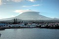
View of the port of Madalena and the Pico

Parish Church of Igreja Santa Maria Madalena
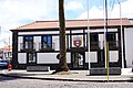
town hall

Rua Carlos Dabney and the Império do Espírito Santo da Madalena chapel
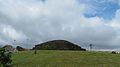
Park "Jardim dos Maroicos" in Madalena

Traditional style residential building

Solar dos Salemas mansion

Wine museum

.JPG)


Web links
Individual evidence
- ↑ www.ine.pt - indicator resident population by place of residence and sex; Decennial in the database of the Instituto Nacional de Estatística
- ↑ a b Overview of code assignments from Freguesias on epp.eurostat.ec.europa.eu
- ↑ www.ine.pt - indicator resident population by place of residence and sex; Decennial in the database of the Instituto Nacional de Estatística
- ↑ www.monumentos.pt (under Cronologia ), accessed on August 28, 2013
- ↑ Michael Bussmann: Azoren , p. 392. Erlangen 2016
- ↑ Publiçor: Guía Turístico dos Açores - Grupo Central , p. 78. Ponta Delgada 2015
- ↑ Publiçor: Guía Turístico dos Açores - Grupo Central , p. 79. Ponta Delgada 2015
- ↑ Stéphan Szeremeta: Açores , p. 216. Paris 2014
- ↑ Stéphan Szeremeta: Açores , p. 211. Paris 2014
- ↑ www.anmp.pt , accessed on August 28, 2013
